The introductions of the country, dependency and region entries are in the native languages and in English. The other introductions are in English.
|
|
|
Atlas-country

|
Mongolia
|
|
|
|
|
|
|
|
Монгол улс
|
|
|
|
| Монгол
|
Монгол улс
[1]
Монгол улс
нь Ази тивийн з??н хойд хэсэгт, ОХУ болон БНХАУ-ын дунд эх газрын т?вд оршдог. Газар нутгийн хэмжээ нь 1.565.600 хавтгай д?рв?лжин км, энэ нь Франц улсын газар нутгаас 3 дахин том юм. Нутгийн з??н, баруун болон ?мн?д хэсгээр нийт 4673 км БНХАУ-тай, хойд талаараа 3485 км-ийг ОХУ-тай хиллэдэг юм.
|
| English
|
Mongolia
- Mongolia
Mongolia
is the largest fully landlocked country typically classified as being a part of East Asia, though it is sometimes considered as being a part of Central Asia instead. It is bordered by
? Russia
and its republics
? Altai Republic
,
? Tuva
and
? Buryatia
to the north and
? China
with
? Xinjiang
and
? Inner Mongolia
to the south. Mongolia's political system is parliamentary democracy and capital and largest city is Ulaanbaatar.
|
|
|
|
| Short name
|
Mongolia
|
| Official name
|
Mongolia
|
| Status
|
Independent country since 1921
|
| Location
|
East Asia
|
| Capital
|
Улаанбаатар
[2]
(Ulan Bator)
|
| Population
|
3,279,404 inhabitants
|
| Area
|
1,564,116 square kilometres (603,909 sq mi)
|
| Major languages
|
Mongolian (official) and Kazakh
|
| Major religions
|
Buddhism and Atheism
|
| More information
|
Mongolia
,
Geography of Mongolia
,
History of Mongolia
and
Politics of Mongolia
|
| More images
|
Mongolia
-
Mongolia (Category)
.
|
|
General maps

|
Map of Mongolia
|

|
Map of Mongolia
|
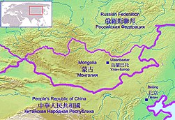
|
Relief map
|

|
Topographic map
|
Maps of divisions
This section holds maps of the administrative divisions.
-
All aimags in different colors (german language)
-
Архангай аймаг
Arkhangai Aimag
-
Баян-?лгий аймаг
Bayan-Olgiy Aimag
-
Баянхонгор аймаг
Bayankhongor Aimag
-
Булган аймаг
Bulgan Aimag
-
Дархан-Уул аймаг
Darkhan-Uul Aimag
-
Дорнод аймаг
Dornod Aimag
-
Дорноговь аймаг
Dornogovi Aimag
-
Дундговь аймаг
Dundgovi Aimag
-
Говь-Алтай аймаг
Govi-Altai Aimag
-
Говьс?мбэр аймаг
Gobisumber Aimag
-
Хэнтий аймаг
Khentii Aimag
-
Ховд аймаг
Khovd Aimag
-
Х?всг?л аймаг
Khuvsgul Aimag
-
Орхон аймаг
Orkhon Aimag
-
Сэлэнгэ аймаг
Selenge Aimag
-
С?хбаатар аймаг
Sukhbaatar Aimag
-
Т?в аймаг
Tov Aimag
-
?мн?говь аймаг
Omnogovi Aimag
-
Увс аймаг
Uvs Aimag
-
?в?рхангай аймаг
Ovorkhangay Aimag
-
Завхан аймаг
Zavkhan Aimag
-
Улаанбаатар хот
Capital Ulaanbaatar
-
Архангайн сумд
Sums of Arkhangai
-
Баян-?лгийн сумд
Sums of Bayan-Olgii
-
Баянхонгорын сумд
Sums of Bayankhongor
-
Булганы сумд
Sums of Bulgan
-
Дархан-Уулын сумд
Sums of Darkhan-Uul
-
Дорнодын сумд
Sums of Dornod
-
Дорноговийн сумд
Sums of Dornogovi
-
Дундговийн сумд
Sums of Dundgovi
-
Говь-Алтайн сумд
Sums of Govi-Altai
-
Говьс?мбэрийн сумд
Sums of Govisumber
-
Хэнтийн сумд
Sums of Khentii
-
Ховдын сумд
Sums of Khovd
-
Х?всг?лийн сумд
Sums of Khovsgol
-
?мн?говийн сумд
Sums of Omnogovi
-
Орхоны сумд
Sums of Orkhon
-
?в?рхангайн сумд
Sums of Ovorhangai
-
Сэлэнгийн сумд
Sums of Selenge
-
С?хбаатарын сумд
Sums of Sukhbaatar
-
Т?в аймгийн сумд
Sums of Tov
-
Увсын сумд
Sums of Uvs
-
Завханы сумд
Sums of Zavkhan
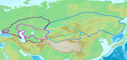
History maps
This section holds a short summary of the history of the area of present-day Mongolia, illustrated with maps, including historical maps of former countries and empires that included present-day Mongolia.

|
Map of the Xianbei (Syanbi, Sarbi) state (1st-3rd century)
|
|
Map of the Western (purple) and Eastern (blue)
Gokturk
Khaganates
at their height, ca. 600 CE. Lighter areas show direct rule; darker areas show spheres of influence.
|
|
Mongolia, the Mongols and the past Mongol Empire
|
|
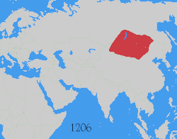
Map showing changes in borders of the
Mongol Empire
from founding by
Genghis Khan
in 1206, Genghis Khan's death in 1227 to the rule of
Kublai Khan
(1260?1294). (Uses modern day borders)
By 1294 the empire had split into:
|
|
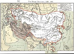
Mongol Empire in 1300-1400
|

|
Mongolia in the 1910s
|
Other maps

|
DEM map
|
Satellite maps
|
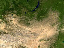
Satellite map
|
Notes and references
General remarks:
- The WIKIMEDIA COMMONS Atlas of the World is an organized and commented collection of geographical, political and historical maps available at Wikimedia Commons. The main page is therefore the portal to
maps
and
cartography
on Wikimedia. That page contains links to entries by country, continent and by topic as well as general
notes and references
.
- Every entry has an introduction section in English. If other languages are native and/or official in an entity, introductions in other languages are added in separate sections. The text of the introduction(s) is based on the content of the Wikipedia encyclopedia. For sources of the introduction see therefore the Wikipedia entries linked to. The same goes for the texts in the history sections.
- Historical maps are included in the continent, country and dependency entries.
- The status of various entities is disputed. See the content for the entities concerned.
- The maps of former countries that are more or less continued by a present-day country or had a territory included in only one or two countries are included in the atlas of the present-day country. For example the Ottoman Empire can be found in the
Atlas of Turkey
.
- ↑
Romanization:
Mongol Uls
.</reditos jsf>
- ↑
Romanization: Ulaanbaatar.
|
Entries available in the atlas
- General pages
- World
- Continents and oceans
- Themes
- Historical eras
- States with wide recognition
- States with limited recognition
- Dependencies and other overseas territories
- Country subdivisions
- Belgium
- China (mainland)
- India
- Pakistan
- Spain
- United Kingdom
- United States
- Other
- Disputed subnational territories
- Other regions
- Cities
- Former sovereign states
- Former dependencies and overseas territories
- Former disputed territories
References
|
