The introductions of the country, dependency and region entries are in the native languages and in English. The other introductions are in English.
|
|
|
Atlas-country
|
Gabon
|
|
|
|
|
|
|
|
Gabon
|
|
|
|
| Francais
|
Gabon
- Republique gabonaise
La
Republique gabonaise
est un pays a l'ouest de l'Afrique centrale tres peu peuple. Situe entre le Congo, la Guinee equatoriale et le Cameroun, c’est un pays forestier ou la faune et la flore sont encore bien conservees. Anciennement implique dans le commerce triangulaire, puis colonie francaise, le Gabon est independant depuis 1960.
|
| English
|
Gabon
- Gabonese Republic
The
Gabonese Republic
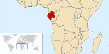
is a country in west central Africa. It borders on
? Equatorial Guinea
,
? Cameroon
,
? Republic of the Congo
and the Gulf of Guinea with
? Sao Tome and Principe
. A small population, abundant natural resources, and foreign private investment have helped make Gabon one of the most prosperous countries in the region.
|
|
|
|
| Short name
|
Gabon
|
| Official name
|
Gabonese Republic
|
| Status
|
Independent country since 1960
|
| Location
|
Central Africa
|
| Capital
|
Libreville
|
| Population
|
1,811,079 inhabitants
|
| Area
|
267,668 square kilometres (103,347 sq mi)
|
| Major languages
|
French (official), languages of the ethnic groups
|
| Major religions
|
Roman Catholicism and Animism
|
| More information
|
Gabon
,
Geography of Gabon
,
History of Gabon
and
Politics of Gabon
|
| More images
|
Gabon
-
Gabon (Category)
.
|
|
General maps

|
Carte du Gabon
Map of Gabon
|

|
Carte du Gabon
Map of Gabon
|
|
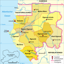
Carte politique
Political map (in German)
|
History maps
This section holds a short summary of the history of the area of present-day Gabon, illustrated with maps, including historical maps of former countries and empires that included present-day Gabon.
Maps of divisions
This section holds maps of the administrative divisions.
-
Departements d'Estuaire
-
Departements de Haut-Ogooue
-
Departements de Moyen-Ogooue
-
Departements de Ngounie
-
Departements de Nyanga
-
Departements d'Ogooue-Ivindo
-
Departements d'Ogooue-Lolo
-
Departements d'Ogooue-Maritime
-
Departements de Woleu-Ntem
Ethnic maps (Cartes ethniques)

|
Maka-Njem ethinies (Ethnic groups)
|
Satellite maps

|
Carte satellite
Satellite map
|

|
Carte satellite
Satellite map
|
Notes and references
General remarks:
- The WIKIMEDIA COMMONS Atlas of the World is an organized and commented collection of geographical, political and historical maps available at Wikimedia Commons. The main page is therefore the portal to
maps
and
cartography
on Wikimedia. That page contains links to entries by country, continent and by topic as well as general
notes and references
.
- Every entry has an introduction section in English. If other languages are native and/or official in an entity, introductions in other languages are added in separate sections. The text of the introduction(s) is based on the content of the Wikipedia encyclopedia. For sources of the introduction see therefore the Wikipedia entries linked to. The same goes for the texts in the history sections.
- Historical maps are included in the continent, country and dependency entries.
- The status of various entities is disputed. See the content for the entities concerned.
- The maps of former countries that are more or less continued by a present-day country or had a territory included in only one or two countries are included in the atlas of the present-day country. For example the Ottoman Empire can be found in the
Atlas of Turkey
.
|
Entries available in the atlas
- General pages
- World
- Continents and oceans
- Themes
- Historical eras
- States with wide recognition
- States with limited recognition
- Dependencies and other overseas territories
- Country subdivisions
- Belgium
- China (mainland)
- India
- Pakistan
- Spain
- United Kingdom
- United States
- Other
- Disputed subnational territories
- Other regions
- Cities
- Former sovereign states
- Former dependencies and overseas territories
- Former disputed territories
|
