The introductions of the country, dependency and region entries are in the native languages and in English. The other introductions are in English.
|
|
|
Atlas-country

|
Armenia
|
|
|
|
|
|
|
|
????????
|
|
|
|
| ???????
|
????????
(????) - ????????? ???????????????
[1]
?????????
, (
????????? ???????????????
), ?????????? ? ???????? ? ?????? ????????????, ??. ?????????, ????????? ? ?????????? ??????????? 1991-??: 5-?? ?????? ?????? ??????? ???????? ? ???????? ???? (???? ????), ??? ????? ????? ?????????? ?: ????????? ????? ??? ?????????? ???????? ?` 301?.-??:
|
| English
|
Armenia
- Republic of Armenia
The
Republic of
Armenia
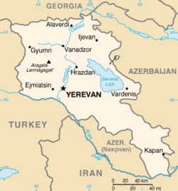
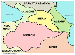
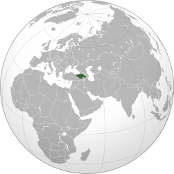
is a landlocked mountainous country in Eurasia between the Black Sea and the Caspian Sea, located in the Southern Caucasus. It shares borders with
? Turkey
to the west,
? Georgia
to the north,
? Azerbaijan
with the break away republic of
? Artsakh
to the east, and
? Iran
and the
? Nakhichevan
exclave of Azerbaijan to the south.
|
|
|
|
| Short name
|
Armenia
|
| Official name
|
Republic of Armenia
|
| Status
|
Independent country since 1990, recognized 1991
|
| Location
|
Caucasus
|
| Capital
|
??????, Yerevan)
|
| Population
|
2,965,269 inhabitants
|
| Area
|
29,800 square kilometres (11,500 sq mi)
|
| Major languages
|
Armenian (official)
|
| Major religions
|
Armenian Apostolic Church
|
| More information
|
Armenia
,
Geography of Armenia
,
History of Armenia
and
Politics of Armenia
|
| More images
|
Armenia
-
Armenia (Category)
.
|
|
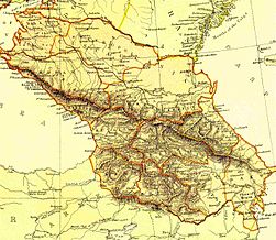
General maps
|
Map of Armenia
|

|
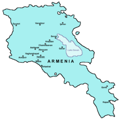
Detailed map of Armenia
|

|
Topography of Armenia
|
|
Largest cities and towns of Armenia
|
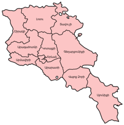
Maps of divisions
This section holds maps of the administrative divisions.
|
Names of the provinces in Armenian
|
-
Provinces of Armenia
-
Provinces of Armenia
-
Aragatsotn
-
Aragatsotn
-
Ararat
-
Ararat
-
Armavir
-
Armavir
-
Gegharkunik
-
Kotyak
-
Lori
-
Shirak
-
Syunik
-
Tavush
-
Vayots Dzor
History maps
This section holds a short summary of the history of the area of present-day Armenia, illustrated with maps, including historical maps of former countries and empires that included present-day Armenia.

|
Between 1500 - 1200 BC, states and tribes called
Mitanni
and
Hayasa-Azzi
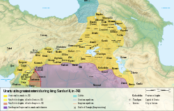
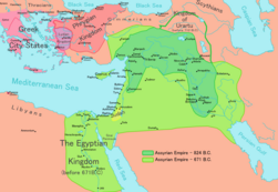
existed in the western half of the Armenian Highland, often clashing with the Hittite Empire. Between 1200 - 800 BC, much of Armenia was united under a confederation of kingdoms, which Assyrian sources called Nairi ("Land of Rivers" in Assyrian). The Egyptians used Nairi for Mitanni, referring to the "Land of Rivers". Nairi was later absorbed into the kingdom of Urartu. The Armenian state of
Urartu
exists between the ninth and sixth century BC. The second map shows
Urartu
at its greatest extent in the time of
Sarduris II
, 743 BC. The following maps show the territorial development of Urartu between 860 and 585 BC.
|
|
|
The Region in the 9th to 7th centuries BC
|

|
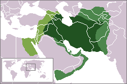
After the fall of Urartu around 585 BC, the Kingdom of Armenia was ruled by the Armenian Orontid Dynasty, which governed the state in 585 - 190 BC. Under Orontids, Armenia at times was an independent kingdom, and at other times a satrapy of the Persian Empire. This map shows the
Achaemid Empire
(
Persia
(648?330 BC) at its greatest extent. More maps:
Atlas of the Persian Empire
.
|
|
After the death of Alexander the Great, Armenia becomes part of the
Seleucid Empire
.
|

|
Kingdom of Armenia around 300 BC under the
Orontid Dynasty
is most of the time a Seleucid vasal state. See also the next map.
|
|
Kingdom of Armenia around 300 BC under the
Orontid Dynasty
is most of the time a Seleucid vasal state. See also the next map.
|

|
Kingdom of Armenia in 250 BC.
|

|
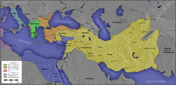
After the destruction of the Seleucid Empire, a Hellenistic Armenian state was founded in 190 BC, with Artaxias becoming its first kings and the founder of the Artaxiad dynasty (190 BC - 1 AD). At the same time, a western portion of the kingdom split as a separate state under Zariadris, which became known as Lesser Armenia while the main kingdom acquired the name of Greater Armenia. At its zenith, from 95 to 66 BC, Greater Armenia extended its rule over parts of the Caucasus and the area that is now eastern and central Turkey, northwestern Iran, Palestine, Syria and Lebanon, forming the second Armenian empire. For a time, Armenia was one of the most powerful states in the Roman East. It eventually confronted the Roman Republic in a war, which it lost in 66 BC, but nonetheless preserved its sovereignty.
Tigranes
continued to rule Armenia as an ally of Rome until his death in 55 BC. This map shows Armenia between 189 and 63 BC.
|

|

|
Later on, in 1 AD, Armenia came under Roman control until the establishment of the Armenian Arsacid dynasty. The Armenian people then adopted a Western political, philosophical, and religious orientation. For more maps see the
Atlas of the Roman Empire
.
|

|
Armenia was often a focus of contention between Rome and Parthia. This map shows the
Parthian
Empire (250 BC-226 AD) controlling parts of Armenia. The Parthians forced Armenia into submission from 37 to 47, when the Romans retook control of the kingdom.
|

|
Under Nero, the Romans fought a campaign (55?63) against the Parthian Empire, which had invaded Armenia. After gaining (60) and losing (62) Armenia, the Romans entered (63) into the territories of Vologases I of Parthia, and returned the Armenian kingdom to Tiridates, founder of the Arshakuni Dynasty. This map shows Armenia under the
Arshakuni Dynasty
.
|
|
The Persian
Sassanian Empire
occupied Armenia in 252 and held it until the Romans returned in 287. In 387 the kingdom was split between the Byzantine or East Roman Empire and the Persians. Western Armenia quickly became a province of the Roman Empire under the name of Armenia Minor; Eastern Armenia remained a kingdom within Persia until 428, when the local nobility overthrew the king, and the Sassanids installed a governor in his place. For more maps see the
Atlas of the Persian Empire
.
|
|
In 591, the great Byzantine warrior and Emperor Maurice defeated the Persians and recovered much of the remaining territory of Armenia into the empire. The conquest was completed by the Emperor Heraclius in 629. See for more maps the
Atlas of the Byzantine Empire
.
|
|
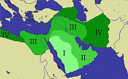
In 645, the Muslim Arab armies of the Caliphate had attacked the country, which fell before them. Armenia, which once had its own rulers and was at other times under Persian and Byzantine control, passed largely into the power of the Caliphs. This map shows the expansion of the
Caliphate
: I: Muhammad; II: Abu Bakr; III: Omar and IV: Othman. See for more maps the
Atlas of the Caliphate
.
|

|
This map shows the Armenian Kingdom of
Vaspourakan
in the 10th century
|
|
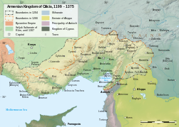
To escape death or servitude at the hands of those who had assassinated his relative, Gagik II, King of Ani, an Armenian named Roupen with some of his countrymen went into the gorges of the Taurus Mountains and then into Tarsus of Cilicia. Here the Byzantine governor of the place gave them shelter. Thus, from around 1080 to 1375, the focus of Armenian nationalism moved south, as the Armenian Kingdom of Cilicia. This map shows Cilician Armenia 1199-1375
|
|
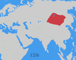
This map shows changes in borders of the
Mongol Empire
from founding by
Genghis Khan
in 1206, Genghis Khan's death in 1227 to the rule of
Kublai Khan
(1260?1294). (Uses modern day borders). For certain times, Armenia was under control of the Mongols.
By 1294 the empire had split into:
|
|
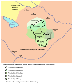
Five principalities of Karabakh (Gyulistan, Jaraberd, Khachen, Varand, Dizaq), the last relict of Armenian statehood (16th century)
|

|
Armenia is conquered under the rule of Selim II (1524 ? 1574) by the
Ottoman Empire
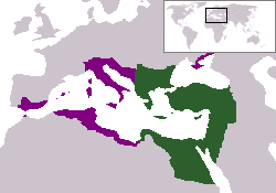
. However, the initial accession begins with Mehmed II, who also offered the Ottoman support to initiate Armenian Patriarch in Constantinople. This rule continued 300 years till the following the Russo?Turkish War (1828?1829), when the Eastern Armenia of this territory was ceded to the Russian Empire. The remaining Ottoman Armenia, till World War I, under Ottoman rule was also referred to as Western Armenia. See for more maps the
Atlas of the Ottoman Empire
.
|

|
The western part became part of the Ottoman Empire. Major Armenian extermination sites in the Ottoman Empire during the
Armenian Genocide
.
|

|
Armenia in 1914
|
|
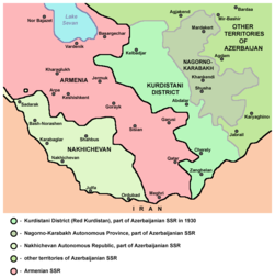
Southern Armenia and Nagorno-Karabakh in Soviet Caucasus, 1930.
|
|
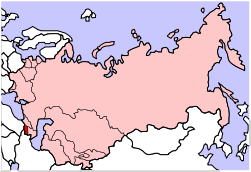
Armenia inside the Soviet Union
|
Armenia regains independence in 1991.
Old maps
This section holds copies of original general maps more than 70 years old.

|
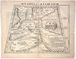
Old map of Armenia from 1522
|
|
Old map of Armenia from 1522
|
|
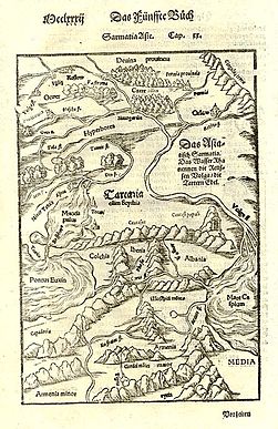
Old map of Armenia from 1579
|

|
Caucasus in 1729
|
|
Map of Armenia and the South Caucasus in the Russian Empire from 1882
|
|
Wilsonian Armenia with Eastern Armenia (political concept)
|
Ethnic maps
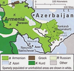
|
Demographic map
|
Satellite maps

|
Satellite image of Armenia from May 2003
|
Notes and references
General remarks:
- The WIKIMEDIA COMMONS Atlas of the World is an organized and commented collection of geographical, political and historical maps available at Wikimedia Commons. The main page is therefore the portal to
maps
and
cartography
on Wikimedia. That page contains links to entries by country, continent and by topic as well as general
notes and references
.
- Every entry has an introduction section in English. If other languages are native and/or official in an entity, introductions in other languages are added in separate sections. The text of the introduction(s) is based on the content of the Wikipedia encyclopedia. For sources of the introduction see therefore the Wikipedia entries linked to. The same goes for the texts in the history sections.
- Historical maps are included in the continent, country and dependency entries.
- The status of various entities is disputed. See the content for the entities concerned.
- The maps of former countries that are more or less continued by a present-day country or had a territory included in only one or two countries are included in the atlas of the present-day country. For example the Ottoman Empire can be found in the
Atlas of Turkey
.
- ↑
Romanization:
Hayastan (Hayq)- Hayastani Hanrapetutyun
.
|
Entries available in the atlas
- General pages
- World
- Continents and oceans
- Themes
- Historical eras
- States with wide recognition
- States with limited recognition
- Dependencies and other overseas territories
- Country subdivisions
- Belgium
- China (mainland)
- India
- Pakistan
- Spain
- United Kingdom
- United States
- Other
- Disputed subnational territories
- Other regions
- Cities
- Former sovereign states
- Former dependencies and overseas territories
- Former disputed territories
References
|
