最大 解像度입니다.
파일 歷史
날짜/時間 링크를 클릭하면 該當 時間의 파일을 볼 수 있습니다.
| 날짜/時間
| 섬네일
| 크기
| 使用者
| 說明
|
|---|
| 現在
| 2005年 3月 24日 (木) 21:17
|  | 280 × 230
(15 KB)
| Voyager
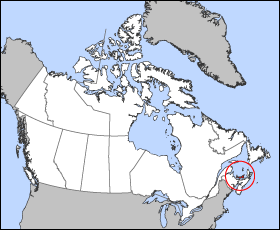
| Map of Prince Edward Island Projection: Lambert azimuthal equal-area Geospatial data from: [http://atlas.gc.ca/ The Atlas of Canada], [http://www.nationalatlas.gov/ The National Atlas of the United States] and [http://www.usgs.gov U.S. Geological Survey
|
이 파일을 使用하는 文書
다음 文書 1個가 이 파일을 使用하고 있습니다:
이 파일을 使用하고 있는 모든 위키의 文書 目錄
다음 위키에서 이 파일을 使用하고 있습니다:
- bat-smg.wikipedia.org에서 이 파일을 使用하고 있는 文書 目錄
- be.wikipedia.org에서 이 파일을 使用하고 있는 文書 目錄
- en.wikipedia.org에서 이 파일을 使用하고 있는 文書 目錄
- en.wiktionary.org에서 이 파일을 使用하고 있는 文書 目錄
- eo.wikipedia.org에서 이 파일을 使用하고 있는 文書 目錄
- fi.wikivoyage.org에서 이 파일을 使用하고 있는 文書 目錄
- frr.wikipedia.org에서 이 파일을 使用하고 있는 文書 目錄
- hu.wiktionary.org에서 이 파일을 使用하고 있는 文書 目錄
- hy.wikipedia.org에서 이 파일을 使用하고 있는 文書 目錄
- io.wikipedia.org에서 이 파일을 使用하고 있는 文書 目錄
- ja.wikipedia.org에서 이 파일을 使用하고 있는 文書 目錄
- kw.wikipedia.org에서 이 파일을 使用하고 있는 文書 目錄
- lij.wikipedia.org에서 이 파일을 使用하고 있는 文書 目錄
- mk.wikipedia.org에서 이 파일을 使用하고 있는 文書 目錄
- nn.wikipedia.org에서 이 파일을 使用하고 있는 文書 目錄
- pam.wikipedia.org에서 이 파일을 使用하고 있는 文書 目錄
- pl.wikipedia.org에서 이 파일을 使用하고 있는 文書 目錄
- pms.wikipedia.org에서 이 파일을 使用하고 있는 文書 目錄
- ru.wikipedia.org에서 이 파일을 使用하고 있는 文書 目錄
- sh.wikipedia.org에서 이 파일을 使用하고 있는 文書 目錄
- simple.wikipedia.org에서 이 파일을 使用하고 있는 文書 目錄
- sl.wikipedia.org에서 이 파일을 使用하고 있는 文書 目錄
- uk.wikipedia.org에서 이 파일을 使用하고 있는 文書 目錄
- vo.wikipedia.org에서 이 파일을 使用하고 있는 文書 目錄
- xmf.wikipedia.org에서 이 파일을 使用하고 있는 文書 目錄
- zh-min-nan.wikipedia.org에서 이 파일을 使用하고 있는 文書 目錄
