原本 파일
(SVG 파일, 實際 크기 512 × 376 픽셀, 파일 크기: 704 KB)
 | Datasource (reference to visualized facts) is not provided for the data that is visualized in this self-made work.
|
파일 說明
SVG Support
This document is in the
Scalable Vector Graphic
format (SVG) and requires a supported browser (Firefox, Google Chrome, Opera) or a SVG plugin for Internet Explorer and other browsers.
SVG is an open, text-based format, which means this map can be downloaded and modified/translated completely using a vector graphics editor like
Adobe Illustrator
or
Inkscape
(free) or a text editor such as
Notepad
.
라이선스
| Public domain
Public domain
false
false
|

|
나는 이 作品의 著作權者로서, 이 作品을
퍼블릭 도메인
으로 모두에게 公開합니다. 이 公開 宣言은 全 世界的으로 有效합니다.
萬若 著作權의 抛棄가 法律的으로 可能하지 않은 境遇,
나는 이 作品을 法的으로 許容되는 限度 內에서 누구나 自由롭게
어떤 目的으로도
制限없이 使用할 수 있도록 許容합니다.
|
이 파일이 나타내는 바에 對한 한 줄 說明을 追加합니다
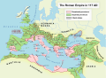
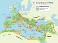
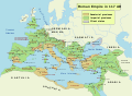
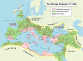
Map of the maximum extent of the Roman Empire
Mapa de la extension maxima del Imperio Romano
Karte des Romische Reich zur Zeit seiner maximalen Ausdehnung
Extentum maximum de Imperium Romanum
파일 歷史
날짜/時間 링크를 클릭하면 該當 時間의 파일을 볼 수 있습니다.
| 날짜/時間
| 섬네일
| 크기
| 使用者
| 說明
|
|---|
| 現在
| 2022年 11月 24日 (木) 20:48
|  | 512 × 376
(704 KB)
| Vikarna
| alpes poeniae → alpes poeninae
|
| 2021年 9月 2日 (木) 11:36
|  | 512 × 376
(696 KB)
| OgreBot
| (BOT): Reverting to most recent version before archival
|
| 2021年 9月 2日 (木) 11:36
|  | 2,180 × 1,600
(1.96 MB)
| OgreBot
| (BOT): Uploading old version of file from en.wikipedia; originally uploaded on 2008-12-10 00:59:00 by
Andrein
|
| 2021年 9月 2日 (木) 11:36
|  | 2,180 × 1,600
(1.96 MB)
| OgreBot
| (BOT): Uploading old version of file from en.wikipedia; originally uploaded on 2008-12-10 00:54:46 by
Andrein
|
| 2021年 9月 2日 (木) 11:36
|  | 2,180 × 1,600
(1.96 MB)
| OgreBot
| (BOT): Uploading old version of file from en.wikipedia; originally uploaded on 2008-12-10 00:22:12 by
Andrein
|
| 2021年 9月 2日 (木) 11:36
|  | 2,180 × 1,600
(1.94 MB)
| OgreBot
| (BOT): Uploading old version of file from en.wikipedia; originally uploaded on 2008-12-09 20:41:09 by
Andrein
|
| 2021年 9月 2日 (木) 11:36
|  | 2,180 × 1,600
(639 KB)
| OgreBot
| (BOT): Uploading old version of file from en.wikipedia; originally uploaded on 2008-09-18 15:26:52 by
Andrein
|
| 2021年 9月 2日 (木) 11:35
|  | 2,180 × 1,600
(639 KB)
| OgreBot
| (BOT): Uploading old version of file from en.wikipedia; originally uploaded on 2008-08-28 12:12:21 by
Andrein
|
| 2019年 8月 2日 (금) 11:17
|  | 512 × 376
(696 KB)
| Vikarna
| there was a dot out of the map.
|
| 2018年 8月 31日 (금) 08:13
|  | 2,180 × 1,600
(1.11 MB)
| Begoon
| .
|
이 파일을 使用하는 文書
다음 文書 3個가 이 파일을 使用하고 있습니다:
이 파일을 使用하고 있는 모든 위키의 文書 目錄
다음 위키에서 이 파일을 使用하고 있습니다:
- af.wikipedia.org에서 이 파일을 使用하고 있는 文書 目錄
이 파일의
더 많은 使用 內譯
을 봅니다.
이 파일에는 카메라나 스캐너가 파일을 만들거나 디지털化하는 데 使用하기 위해 記錄한 附加 情報가 包含되어 있습니다.
프로그램에서 파일을 編輯한 境遇, 새로 貯藏한 파일에 一部 附加 情報가 빠질 수 있습니다.
