Village in American Samoa, United States
Utulei
or
?Utulei
is a village in
Maoputasi County
, in the
Eastern District
of
Tutuila
, the main island of
American Samoa
. Utulei is traditionally considered to be a section of Fagatogo village, the
legislative
capital of
American Samoa
, and is located on the southwest edge of
Pago Pago
Harbor.
[1]
Utulei is the site of many local landmarks: The
A. P. Lutali
Executive Office Building, which is next to the
Feleti Barstow Library
; paved roads that wind up to a former cablecar terminal on Solo Hill; the governor's mansion, which sits on Mauga o Alii, overlooking the entrance to Goat's Island, and the lieutenant governor's residence directly downhill from it; the
Lee Auditorium
, built in 1962; American Samoa's television studios, known as the
Michael J. Kirwan Educational Television Center
; and the
Rainmaker Hotel
(a portion of which is now known as
Sadie's Hotel
). Utulei Terminal offers views of
Rainmaker Mountain
.
[2]
Also in Utulei are some of the hotels based in Pago Pago, such as Sadie’s by the Sea,
[3]
and the Feleti Barstow Library (
American Samoa
’s central public library), which is located across from
Samoana High School
.
[4]
[5]
[6]
The library, which has the largest selection of literature in
American Samoa
,
[7]
was developed between 1998 and 2000 with funds from the
Community Development Block Grant
, a program of the
U.S. Department of Housing and Urban Development
.
[
citation needed
]
Utulei Beach Park has an enormous
fale
with ornate carvings, which is used for performances and events. Smaller fales in the park are used for everyday gatherings. Across from Utulei Beach Park is the Executive Office Building and
Feleti Barstow Public Library
. Next to the library is the largest high school on Tutuila Island,
Samoana High School
.
[8]
History
[
edit
]
 Remains of a World War II encampment above Utulei.
 The historic tramway on the World War II Heritage Trail.
Utulei is by tradition considered distinct from Fagatogo because it is the site of Maota o Tanumaleu, the residence of the High Chief Afoafouvale (also known as the Le Aloalii). The current holder of that title is
Afoa Moega Lutu
, who has held it since 1990.
Of historical interest, more than a century ago, on November 3, 1920,
Warren Terhune
, who was the Samoan governor at the time, committed suicide in Utulei.
[10]
During World War II, the population of the village of Utulei, around 700 inhabitants, was almost entirely displaced to make room for US military installations. One Naval officer was said to have describe Utulei as consisting of "a few native houses". The inhabitants were told to move out of the village and into the hills, and bachelor officers’ quarters and other military support facilities were built there.
[11]
After the war, in 1946, the now-vacant two-story marine barracks at Utulei were renovated and repurposed as the new
Samoan Hospital
, with 224 beds, 27 bassinets, a pharmacy, and a dentistry. During the year 1950, the hospital admitted 2,771 patients, and delivered about 40 percent of all babies born in American Samoa that year. Nursing needs were filled by graduates from the local nursing school. Medical needs were filled by students were selected for the
Central Medical School
.
[12]
: 247 and 267
After the Navy's departure in 1951, however, there was a severe shortage of physicians and other health care professionals. In 1954, for example, there were only four doctors (one stateside and three European), and only one dentist. The hospital therefore depended heavily on nurses to provide its patient care.
[12]
: 268
In 1964, the
Michael J. Kirwan Educational Television Center
was completed.
[13]
It is named for Representative
Michael J. Kirwan
, who was chairman of the
House Appropriations Committee
.
[12]
: 279?280
In 1980, during celebratory
Flag Day
military demonstrations, a U.S. Navy airplane accidentally hit the cables of the Mount ‘Alava Cable Car and crashed into the
Rainmaker Hotel
. All six naval personnel on board the aircraft died, as did two hotel guests.
[14]
: 167
Geography
[
edit
]
Surface runoff
- from
Utulei Ridge
, the
Togotogo Ridge
, and
Matai Mountain
- flows through Utulei, carried by the
Vailoa Stream
. The stream discharges into the sea at a point on the north side of the
Pago Pago Yacht Club
in Utulei.
[15]
: 24?26
Utulei Beach Park
[
edit
]
 Beach at Sadie's by the Sea
Utulei Beach Park is one of only a few public parks in
Pago Pago
? and on
Tutuila Island
as a whole. It was built by the
U.S. Navy
in the 1940s by filling in a marshy area near the
Pago Pago Harbor
. Next to the park are two historic naval buildings erected in the 1940s ? two of four remaining original structures built here by the Navy during World War II - as well as the Pago Pago Yacht Club and the ASG Tourism Office. The park includes a grassy area with scattered trees and picnic sites. It is used for recreational activities, such as volleyball and picnicking, and is a common gathering place for social activities and events. The adjoining beach is used for canoe racing, kayaking, and windsurfing.
[16]
In 2006, the governor proposed approving the addition of a
McDonald's
restaurant to Utulei Beach. He said he hoped the restaurant would boost activity during the evenings, a time when the area was usually almost deserted. This was a controversial proposal, because Utulei Beach is a designated park area that has received substantial funding from the
National Park Service
.
[17]
The proposal was defeated.
In 2009,then-Governor
Togiola Tulafono
designated Su’igaula o le Atuvasa as one of the venues for the 10th
Festival of Pacific Arts
, slated to be hosted by American Samoa in the summer of 2010. Su’igaula o le Atuvasa is the portion of the beach closest to the former site of the
Pago Pago Yacht Club
.
[18]
Another public park in Utulei is Su’igaulaoleatuvasa, which is managed by the
American Samoa Parks and Recreation
department.
[19]
Tourism
[
edit
]
 Government House
is located between Utulei and
Fagatogo
.
Government House
is located between Utulei and
Fagatogo
.
 View of
Rainmaker Mountain
from the
Pago Pago Yacht Club
in Utulei.
View of
Rainmaker Mountain
from the
Pago Pago Yacht Club
in Utulei.
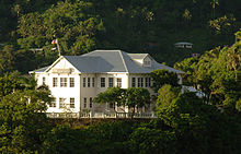
The $10-million
A. P. Lutali
Executive Office Building, constructed in 1991, is located near the Pago Pago Yacht Club. The
Feleti Barstow Public Library
, constructed in 1998, is located just behind the Executive Office Building. Beyond the library is a paved road that winds upwards to the former cable-car terminal on Solo Hill. A monument on the hill recalls a 1980 disaster in which a U.S. Navy airplane hit the cables and crashed into the
Rainmaker Hotel
, killing eight people. The cableway had been one of the world's longest single-span aerial tramways; it had been constructed in 1965 to carry TV technicians to the transmitters at the top of
Mount ?Alava
. In December 1991,
Hurricane Val
put the cableway out of service, and it has yet to be repaired. But the Utulei terminal is still visited because of its views, including its view of Mt. Pioa (also called the
Rainmaker Mountain
.
Also located in Utulei are the
Lee Auditorium
, built in 1962, and the
Michael J. Kirwan Educational Television Center
.
[20]
[14]
: 166
It was at this television center, during the tenure of Governor
H. Rex Lee
, that the pioneering practice began of broadcasting school lessons to elementary and secondary school students Guided tours of the Michael J. Kirwan TV Studios have been available in the past.
[14]
: 167
The two-story
Governor's House
is a wooden colonial mansion atop Mauga o Ali'i (the chief's hill), uphill from a road across which is the entrance to the
Rainmaker Hotel
. The mansion was constructed in 1903, and served as the residence of each of the island’s naval commanders in turn until 1951. At that point, the
Department of the Interior
assumed control of the mansion, and it has been the residence of every
governor of American Samoa
since then.
[14]
: 167
Pago Pago Yacht Club
, next to the Canoe Club in Utulei, is the center of water sports activities in American Samoa. It offers game fishing, diving, canoeing, sailing, diving, and more. The historic club building, next to
Pago Pago Harbor
, is used as a place to retreat and for dining. The yacht club is a member of the
International Yacht Racing Union
and the American Samoa National Olympic Committee.
[21]
Utulei is also home to
Tauese PF Sunia Ocean Center
, which is the visitor center for the
National Marine Sanctuary of American Samoa
. It offers informative exhibits on region's ecosystems and reefs.
[22]
[23]
Blunt's Point
[
edit
]
 Blunts Point Battery
Blunt's Point
, on Matautu Ridge in Gataivai, overlooks the mouth of
Pago Pago Harbor
. On it are two large six-inch naval guns that were emplaced in 1941. Matautu Ridge can be reached from Utulei by walking southeast on the main road past the oil tanks, keeping an eye out on the right-hand side for a small pump house immediately across the highway from a beach, and almost opposite two homes on the bayside of the street. The track up the hill to Matautu Ridge starts behind the pump house. The lower gun is located directly over a big green water tank, and the second gun is located 200 meters farther up the Matautu Ridge. Concrete stairways lead to both of the guns.
[20]
One gun emplacement is listed on the
U.S. National Register of Historic Places
, while the second gun has earned recognition as a
U.S. National Historic Landmark
. They are maintained by the
National Park Service
.
[24]
The 3-km World War II Heritage Trail, which ends at Blunt's Point, is the most accessible and most popular trail on Tutuila Island. The ridge-top trail winds past various ancient archeological sites as well as World War II installations that were erected to fend off a potential Japanese invasion.
[25]
Farther on, the trail leads into a bird-filled rainforest.
[26]
Landmarks
[
edit
]
Economy
[
edit
]
At the time of the
1990 U.S. Census
, there were 156 houses in Utulei village. Between 1990 and 1995, 23 new residential building permits were issued, so that, by 1995, there were 179 houses. As of 2000, there were 60 commercial enterprises registered in the village, many of which are housed in the one- or two-story buildings on the southwest side of the shoreline roadway. Smaller shops are found in predominantly residential communities upland from
Samoana High School
and the
Executive Office Building
.
[15]
: 24-23 and 24-25
Diesel fuel is delivered monthly to
Tutuila Island
from Long Beach, California, and Honolulu, Hawaii, supplied by
Marlex
and Pacific Resources, Inc. The fuel is carried by pipe from the dock area to an energy-storage tank farm operated by Marlex in the
Punaoa Valley
in Utulei.
[27]
Education
[
edit
]
The
American Samoa Department of Education
operates
Samoana High School
in Utulei (originally called the
High School of American Samoa
).
[28]
It opened in 1946, and was the first high school established in the territory.
The
American Samoa Community College
(ASCC), established in 1970, was located in Utulei during its first four years of operation. From 1972 to 1974, it was housed in the former Fia lloa High School building
[29]
and in the former navy buildings that had once housed the
High School of American Samoa
. By the spring of 1972, the college had 872 enrolled students.
[30]
Feleti Barstow Public Library
, the central public library for American Samoa, is located in Utulei.
Notable people
[
edit
]
References
[
edit
]
- ^
Google Maps: Utulei, Eastern, American Samoa
, accessed 12 March 2018.
- ^
Stanley, David (1999).
South Pacific Handbook
. David Stanley. Pages 441-443.
ISBN
9781566911726
.
- ^
Cruise Travel Vol. 2, No. 1
(July 1980). Lakeside Publishing Co. Page 60. ISSN 0199-5111.
- ^
"American samoa"
. Archived from
the original
on 2017-10-22
. Retrieved
2017-10-21
.
- ^
Talbot, Dorinda and Deanna Swaney (1998).
Samoa
. Lonely Planet. Page 158.
ISBN
9780864425553
.
- ^
Stanley, David (1993).
South Pacific Handbook
. David Stanley. Page 367.
ISBN
9780918373991
.
- ^
Goodwin, Bill (2006).
Frommer’s South Pacific
. Wiley. Page 397.
ISBN
9780471769804
.
- ^
Clayville, Melinda (2021).
Explore American Samoa: The Complete Guide to Tutuila, Aunu'u, and Manu'a Islands
. Page 41. ISBN 9798556052970.
- ^
"American Samoa Statistical Yearbook 2016"
(PDF)
.
American Samoa Department of Commerce
.
- ^
"SAMOAN GOVERNOR COMMITS SUICIDE; Naval Commander Terhune of Hackensack, N.J., Shoots Himself when Suspended. WAS TO FACE AN INQUIRY Troubles with Natives Led to Charges Against His Administration There"
.
The New York Times
. 6 November 1920.
- ^
Kennedy, Joseph (2009).
The Tropical Frontier: America’s South Sea Colony
. University of Hawaii Press. Page 201 and 213.
ISBN
9780980033151
.
- ^
a
b
c
Sunia, Fofo I.F. (2009).
A History of American Samoa
. Amerika Samoa Humanities Council.
ISBN
9781573062992
.
- ^
"Weekly Highlight 11/13/2009 Michael J. Kirwan Educational Television Center, Tutuila Island, Western, American Samoa"
.
- ^
a
b
c
d
Swaney, Deanna (1994).
Samoa: Western & American Samoa: a Lonely Planet Travel Survival Kit
. Lonely Planet Publications.
ISBN
9780864422255
.
- ^
a
b
"AMERICAN SAMOA WATERSHED PROTECTION PLAN"
(PDF)
. American Samoa Environmental Protection Agency. January 2000
. Retrieved
19 March
2022
.
- ^
United States National Park Service (1997).
National Park of American Samoa, General Management Plan (GP), Islands of Tutuila, Ta'u, and Ofu: Environmental Impact Statement
. Page 39.
- ^
"American Samoa Governor backs beachfront McDonalds"
. 16 May 2006.
- ^
"Half mil budgeted to improve Su'igaula o le Atuvasa Park"
. Samoa News. 21 July 2013
. Retrieved
19 March
2022
.
- ^
"Park usage numbers increase despite major problems with vandalism and limited facilities"
. 25 February 2013.
- ^
a
b
Stanley, David (2004).
Moon Handbooks South Pacific
. David Stanley. Page 475.
ISBN
9781566914116
.
- ^
International Business Publications IBP, Inc. (2007).
Samoa (American): Doing Business, Investing in Samoa (American) Guide - Strategic Information, Regulations, Contacts
. Lulu Press, Inc. Page 135.
ISBN
9781433011863
.
- ^
"Tauese PF Sunia Ocean Center | American Samoa Attractions"
.
- ^
Atkinson, Brett (2016).
Lonely Planet Rarotonga, Samoa & Tonga
. Lonely Planet Publications. Page 154.
ISBN
9781786572172
.
- ^
"Blunts Point gun encasements cleaned up"
. 27 November 2013.
- ^
"American Samoa: Tramping the tropics"
.
- ^
Lomax, Becky (2018).
Moon USA National Parks: The Complete Guide to All 59 Parks
. Moon Travel Guides.
ISBN
9781640492790
.
- ^
"United States of America Insular Areas Energy Assessment Report"
. Department of Interior. p. 152
. Retrieved
19 March
2022
.
- ^
Sutter, Frederic Koehler (1989).
The Samoans: A Global Family
. University of Hawaii Press. Page 215.
ISBN
9780824812386
.
- ^
Crocombe, R.G. and Malama Meleisea (1988).
Pacific Universities: Achievements, Problems, Prospects. The University of the South Pacific
. Page 218.
ISBN
9789820200395
.
- ^
Sunia, Fofo I.F. (2009).
A History of American Samoa
. Amerika Samoa Humanities Council. Page 307.
ISBN
9781573062992
.
External links
[
edit
]
14°17′13″S
170°40′59″W
/
14.28694°S 170.68306°W
/
-14.28694; -170.68306
