Borough
|
FIPS
code
[5]
|
Borough seat
[6]
|
Class
[7]
[8]
[9]
|
Est.
[6]
|
Origin
|
Etymology
|
Density
|
Population
[10]
|
Area
[11]
|
Map
|
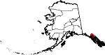
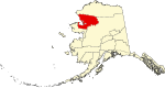
| Aleutians East Borough
|
013
|
Sand Point
|
Second
|
1987
|
-
|
Its location in the east
Aleutian Islands
, which are themselves of uncertain linguistic origin; possibly derived from
Chukchi
word
aliat
("island")
|
0.50
|
3,461
|
6,985
sq mi
(
18,091
km
2
)
|

|
| Anchorage
|
020
|
(
Consolidated
city-borough
)
|
Unified Home Rule
|
1964/1975
|
Anchorage Borough formed in 1964, merged with city in 1975 to form unified city-borough
|
Derived from the presence of a safe place to anchor and unload supplies for construction of the Alaska Railroad
c.
1913
, thereby creating a community.
|
167.59
|
286,075
|
1,707
sq mi
(
4,421
km
2
)
|

|
| Bristol Bay Borough
|
060
|
Naknek
|
Second
|
1962
|
-
|
Named in 1778 by Capt.
James Cook
for
George Digby, 2nd Earl of Bristol
.
|
1.75
|
844
|
482
sq mi
(
1,248
km
2
)
|

|
| Denali Borough
|
068
|
Healy
|
Home Rule
|
1990
|
-
|
From
Denali
, the tallest
North American
mountain, which means "great one" in the
Dena'ina language
|
0.13
|
1,584
|
12,641
sq mi
(
32,740
km
2
)
|

|
| Fairbanks North Star Borough
|
090
|
Fairbanks
|
Second
|
1964
|
-
|
Named for its borough seat of
Fairbanks
, named in turn for
Charles Fairbanks
(1852?1918), U.S. Senator from Indiana and vice president under Theodore Roosevelt, and for
Polaris
, the North Star
|
12.93
|
94,840
|
7,335
sq mi
(
18,998
km
2
)
|

|
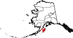
| Haines Borough
|
100
|
(
Consolidated
city-borough
)
|
Home Rule
|
1968
(Consolidated 2002)
|
-
|
After
Haines
, which was itself named for Mrs. Francina E. Haines (1819?1870), the key fundraiser for the construction of a Presbyterian mission in the town.
|
0.88
|
2,070
|
2,343
sq mi
(
6,068
km
2
)
|
|
| Juneau
|
110
|
(
Consolidated
city-borough
)
|
Unified Home Rule
|
1970
|
The cities of Juneau and Douglas merged with the surrounding borough to form the municipality
|
Joseph "Joe" Juneau
(1836-1899), prospector and co-founder of the city.
|
11.67
|
31,555
|
2,704
sq mi
(
7,003
km
2
)
|

|
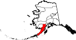
| Kenai Peninsula Borough
|
122
|
Soldotna
|
Second
|
1964
|
-
|
The
Kenai Peninsula
, whose name may be derived from
Kenayskaya
, the
Russian
name for
Cook Inlet
.
|
3.82
|
61,223
|
16,017
sq mi
(
41,484
km
2
)
|

|
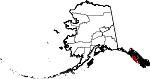
| Ketchikan Gateway Borough
|
130
|
Ketchikan
|
Second
|
1963
|
-
|
The borough seat of
Ketchikan
and the borough's gateway location on the
Alaska
-
Canada
border.
|
2.83
|
13,738
|
4,857
sq mi
(
12,580
km
2
)
|

|
| Kodiak Island Borough
|
150
|
Kodiak
|
Second
|
1963
|
-
|
Named after
Kodiak Island
, which may itself be named for the Koniag people
|
1.88
|
12,565
|
6,689
sq mi
(
17,324
km
2
)
|
|
| Lake and Peninsula Borough
|
164
|
King Salmon
|
Home Rule
|
1989
|
-
|
The borough's many large
lakes
, and the
Alaska Peninsula
|
0.06
|
1,331
|
23,832
sq mi
(
61,725
km
2
)
|
|
| Matanuska-Susitna Borough
|
170
|
Palmer
|
Second
|
1964
|
-
|
Named for the
valley
that the
Matanuska
and
Susitna
Rivers form.
|
4.66
|
115,239
|
24,707
sq mi
(
63,991
km
2
)
|

|
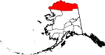
| North Slope Borough
|
185
|
Utqia?vik
|
Home Rule
|
1972
|
-
|
The
Alaska North Slope
along the
Brooks Range
.
|
0.12
|
10,603
|
88,824
sq mi
(
230,053
km
2
)
|
|
| Northwest Arctic Borough
|
188
|
Kotzebue
|
Home Rule
|
1986
|
In 1986, residents of Kotzebue and 10 other area villages voted to form the Northwest Arctic Borough (with boundaries coincident with those of
NANA
), to be economically based on taxing the Red Dog mine, then under development.
|
Its geographic location and position above the
Arctic Circle
.
|
0.21
|
7,361
|
35,663
sq mi
(
92,367
km
2
)
|
|
| Petersburg Borough
|
195
|
Petersburg
|
Home Rule
|
2013
|
Incorporated after voters approved borough formation in December 2012.
|
Named for Norwegian immigrant Peter Buschmann (1849-1903), founder of the former city of Petersburg.
|
1.18
|
3,427
|
2,901
sq mi
(
7,514
km
2
)
|
|
| Sitka
|
220
|
(
Consolidated
city-borough
)
|
Unified Home Rule
|
1971
|
-
|
Derived from
Tlingit
word
Shee At'ika
, meaning "People on the outside of Shee (
Baranof Island
)."
|
2.89
|
8,282
|
2,870
sq mi
(
7,433
km
2
)
|
|
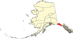
| Skagway
|
230
|
(
Consolidated
city-borough
)
|
First
|
2007
|
-
|
Derived from
Tlingit
word
Shgagwei
, meaning "a windy place with white caps on the water."
|
2.52
|
1,095
|
434
sq mi
(
1,124
km
2
)
|

|
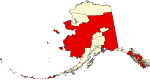
| Unorganized Borough
|
-
|
-
|
-
|
1961
|
The Borough Act of 1961 created
The Unorganized Borough
including all of Alaska not within a Unified, Home rule, First class or Second class borough.
|
A legal entity in Alaska, covering those parts of Alaska not within an
incorporated
borough; it is directly administered by the State of Alaska.
[12]
|
0.24
|
75,362
|
319,852
sq mi
(
828,413
km
2
)
|
|
| Wrangell
|
275
|
(
Consolidated
city-borough
)
|
Unified Home Rule
|
2008
|
Formerly part of
Wrangell-Petersburg Census Area
|
Ferdinand von Wrangel
,
Russian
administrator of Alaska, 1840-49.
|
0.81
|
2,064
|
2,556
sq mi
(
6,620
km
2
)
|

|
| Yakutat
|
282
|
(
Consolidated
city-borough
)
|
Home Rule
|
1992
|
-
|
Yakutat Bay
and the
Yakutat
Alaska Native
people
|
0.09
|
687
|
7,623
sq mi
(
19,743
km
2
)
|
|
