Australian external territory in the sub-Antarctic region
Territory of
Heard Island and McDonald Islands
A southwesterly view of Heard Island in 2009.
Flag of Australia (used for Heard Island and the McDonald Islands)
|
 |
|
| Location
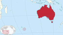
| Indian Ocean
|
|---|
| Major islands
| 2
|
|---|
| Area
| 368 km
2
(142 sq mi)
|
|---|
| Highest elevation
| 2,745 m (9006 ft)
|
|---|
| Highest point
| Mawson Peak
|
|---|
|
|
|
|
|
|
| Criteria
| Natural: viii, ix
|
|---|
| Reference
| 577
|
|---|
| Inscription
| 1997 (21st
Session
)
|
|---|
| Area
| 658,903 ha (2544 sq. mi.)
|
|---|
|
|
The
Territory of Heard Island and McDonald Islands
[1]
[2]
(
HIMI
;
[3]
ISO 3166
region code: HMD, HM, 334;
[4]
) is an Australian
external territory
comprising a
volcanic group
of mostly barren
Antarctic
islands, about two-thirds of the way from
Madagascar
to
Antarctica
. The group's overall area is 372 km
2
(144 sq mi) and it has 101.9 km (63 mi) of coastline. Discovered in the mid-19th century, the islands lie on the
Kerguelen Plateau
in the
Indian Ocean
and have been an Australian territory since 1947.
They contain Australia's only two active
volcanoes
. The summit of one,
Mawson Peak
, is higher than any mountain in all other Australian states or territories, except
Dome Argus
,
Mount McClintock
and
Mount Menzies
in the
Australian Antarctic Territory
.
The islands are among the
most remote places on Earth
: They are located about 4,100 kilometres (2,200 nautical miles) southwest of
Perth
,
[5]
3,850 km (2,080 nmi) southwest of
Cape Leeuwin
, Australia, 4,200 km (2,300 nmi) southeast of
South Africa
, 3,830 km (2,070 nmi) southeast of
Madagascar
, 1,630 km (880 nmi) north of Antarctica, and 450 km (240 nmi) southeast of the
Kerguelen Islands
(part of
French Southern and Antarctic Lands
).
[6]
The islands, which are uninhabited, can be reached only by sea, which from Australia takes two weeks in the vessels normally used to access them.
[7]
History
[
edit
]
 Heard Island 1887 by
Henry Wood Elliott
[8]
Heard Island 1887 by
Henry Wood Elliott
[8]
Neither island cluster had recorded visitors until the mid-1850s.
An American sailor, John Heard, on the ship
Oriental
, sighted Heard Island on 25 November 1853, en route from
Boston
to
Melbourne
. He reported the discovery one month later and had the island named after him.
[9]
His wife
Fidelia Heard
provided the first written description and drawings of the island.
[10]
[11]
William McDonald aboard the
Samarang
discovered the nearby McDonald Islands
six weeks later, on 4 January 1854.
[9]
No landing took place on the islands until March 1855, when sealers from the
Corinthian
, led by
Erasmus Darwin Rogers
, went ashore at a place called Oil Barrel Point. From 1855 to 1882 a number of American sealers spent a year or more on the island, living in appalling conditions in dark smelly huts, also at Oil Barrel Point. At its peak the community consisted of 200 people. By 1880, sealers had wiped out most of the seal population and then left the island. In all, the islands furnished more than 100,000 barrels of
elephant seal
oil during this period.
[
citation needed
]
A number of wrecks have occurred in the vicinity of the islands. There is also a discarded building left from John Heard's sealing station that is situated near Atlas Cove.
[12]
The islands were formally claimed by the United Kingdom in 1910 and transferred to Australia on 26 December 1947. The transfer was confirmed in letters exchanged on 19 December 1950.
[1]
The archipelago became a
World Heritage Site
in 1997.
The first recorded aircraft landing on McDonald Island was made by Australian scientists Grahame Budd and Hugh Thelander on 12 February 1971, using a helicopter.
[13]
[14]
There were at least five private expeditions to Heard Island between 1965 and 2000. Several
amateur radio
operators have visited Heard, often associated with scientific expeditions. The first activity there was in 1947 by Alan Campbell-Drury. Two amateur radio
DXpeditions
to the island took place in 1983 using the callsigns VK0HI (the
Anaconda
expedition)
[15]
and VK0JS and VK0NL (the
Cheynes II
expedition), with a further operation in January 1997 (VK0IR). The DXpedition in March 2016 (VK0EK) was organised by Cordell Expeditions,
[16]
and made over 75,000 radio contacts.
Mawson Peak, atop Big Ben, was first climbed on 25 January 1965 by five members of the Southern Indian Ocean Expedition to Heard Island (sometimes referred to as the
Patanela
expedition).
[17]
The second ascent was made by five members of the Heard Island Expedition 1983 (sometimes referred to as the
Anaconda
expedition).
[15]
A helicopter landing was made at the summit by an ANARE team on 21 December 1986. An Australian Army team was successful in making the third ascent in 2000.
In 1991, the islands were the location for the
Heard Island feasibility test
, an experiment in very long-distance transmission of low frequency sound through the ocean.
[18]
The US Navy vessels
MV
Cory Chouest
and
Amy Chouest
were used to transmit signals which could be detected as far away as both ocean coasts of the US and Canada.
[19]
Geography
[
edit
]
 Heard Island and McDonald Islands in the Southern Ocean
 A map of Heard Island and McDonald Islands
Heard Island, by far the largest of the group, is a 368-square-kilometre (142 sq mi) mountainous island covered by 41 glaciers
[20]
(the island is 80% covered with ice
[1]
) and dominated by the
Big Ben
massif
. It has a maximum elevation of 2,745 metres (9,006 ft) at
Mawson Peak
, the historically active volcanic summit of Big Ben, to which the average ascent from shore is steeper than that for any island of comparable size or larger;
only seven smaller islands are steeper
. A July 2000 satellite image from the
University of Hawaii
's Institute of Geophysics and Planetology (HIGP) Thermal Alert Team showed an active 2-kilometre-long (1.2 mi) and 50- to 90-metre-wide (164?295 ft) lava flow trending south-west from the summit of Big Ben.
[21]
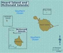
The much smaller and rocky
McDonald Islands
are located 44 kilometres (27 mi) to the west of Heard Island. They consist of McDonald Island (186 m or 610 ft high), Flat Island (55 m or 180 ft high) and
Meyer Rock
(170 m or 560 ft high). They total approximately
2.5 square kilometres (
15
⁄
16
sq mi) in area, where McDonald Island is
1.13 square kilometres (
7
⁄
16
sq mi). There is a small group of islets and rocks about
10 km (
5
+
1
⁄
2
nmi) north of Heard Island, consisting of Shag Islet, Sail Rock, Morgan Island and Black Rock. They total about
1.1 square kilometres (
7
⁄
16
sq mi) in area.
Mawson Peak and McDonald Island are the only two active volcanoes in Australian territory. Mawson Peak is also one of the highest Australian mountains (higher than
Mount Kosciuszko
); surpassed only by
Mount McClintock
range in the
Antarctic territory
.
[22]
Mawson Peak has erupted several times in the last decade; the most recent eruption was filmed on 2 February 2016.
[23]
The volcano on McDonald Island, after being dormant for 75,000 years, became active in 1992 and has erupted several times since, the most recently in 2005.
[24]
Heard Island and the McDonald Islands have no ports or harbours; ships must anchor offshore. The coastline is 101.9 km (63.3 mi) in extent, and a 12 nmi (22 km) territorial sea and 200 nmi (370 km) exclusive fishing zone are claimed.
[1]
Wetlands
[
edit
]
Heard Island has a number of small wetland sites scattered around its coastal perimeter, including areas of wetland vegetation, lagoons or lagoon complexes, rocky shores and sandy shores, including the
Elephant Spit
. Many of these wetland areas are separated by active glaciers. There are also several short glacier-fed streams and glacial pools. Some wetland areas have been recorded on McDonald Island but, due to substantial volcanic activity since the last landing was made in 1980, their present extent is unknown.
The HIMI wetland is listed on the
Directory of Important Wetlands in Australia
and, in a recent analysis of Commonwealth-managed wetlands, was ranked highest for nomination under the
Convention on Wetlands of International Importance Especially as Waterfowl Habitat (Ramsar Convention)
as an internationally important wetland.
Six wetland types have been identified from HIMI covering approximately 1860 ha: coastal 'pool complex' (237 ha); inland 'pool complex' (105 ha); vegetated seeps mostly on recent glaciated areas (18 ha); glacial lagoons (1103 ha); non-glacial lagoons (97ha); Elephant Spit (300 ha) plus some coastal areas. On Heard Island, the majority of these types suites are found below 150 m asl. The wetland vegetation occurs in the 'wet mixed herbfield' and 'coastal biotic vegetation' communities described above.
The wetlands provide important breeding and feeding habitat for a number of Antarctic and subantarctic wetland animals. These include the
southern elephant seal
and
macaroni
,
gentoo
,
king
and
eastern rockhopper
penguins, considered to be wetland species under the Ramsar Convention. Non-wetland vegetated parts of the islands also support penguin and other seabird colonies.
Climate
[
edit
]
 Vortex shedding
as winds pass Heard Island resulted in this
Karman vortex street
in the clouds.
Vortex shedding
as winds pass Heard Island resulted in this
Karman vortex street
in the clouds.
The islands have an Antarctic climate, or
Tundra climate
(
ET
) under the Koppen climate classification, tempered by their maritime setting. The weather is marked by low seasonal and daily temperature ranges; persistent and generally low cloud cover; frequent precipitation and strong winds. Snowfall occurs throughout the year. Monthly average temperatures at
Atlas Cove
(at the northwestern end of Heard Island) range from 0.0 to 4.2 °C (32.0 to 39.6 °F), with an average daily range of 3.7 to 5.2 °C (38.7 to 41.4 °F) in summer and ?0.8 to 0.3 °C (30.6 to 32.5 °F) in winter. The winds are predominantly westerly and persistently strong. At Atlas Cove, monthly average wind speeds range between around 26 and 33.5 km/h (16.2 and 20.8 mph). Gusts in excess of 180 km/h (110 mph) have been recorded.
Annual precipitation at sea level on Heard Island is in the order of 1,300 to 1,900 mm (51.2 to 74.8 in); rain or snow falls on about 3 out of 4 days.
[25]
According to the Australian
Bureau of Meteorology
, Heard Island (Atlas Cove) receives an average of 96.8 snowy days annually.
[26]
Meteorological records at Heard Island are incomplete.
| Climate data for Heard Island (1981?2010); 12 m AMSL; 53.10° S, 73.71° E
|
| Month
|
Jan
|
Feb
|
Mar
|
Apr
|
May
|
Jun
|
Jul
|
Aug
|
Sep
|
Oct
|
Nov
|
Dec
|
Year
|
| Record high °C (°F)
|
20.1
(68.2)
|
18.0
(64.4)
|
19.9
(67.8)
|
20.4
(68.7)
|
19.3
(66.7)
|
14.0
(57.2)
|
15.0
(59.0)
|
15.4
(59.7)
|
16.8
(62.2)
|
16.4
(61.5)
|
14.6
(58.3)
|
19.2
(66.6)
|
20.4
(68.7)
|
| Mean daily maximum °C (°F)
|
6.4
(43.5)
|
6.5
(43.7)
|
6.3
(43.3)
|
5.3
(41.5)
|
3.7
(38.7)
|
2.3
(36.1)
|
2.2
(36.0)
|
2.2
(36.0)
|
2.2
(36.0)
|
3.3
(37.9)
|
4.1
(39.4)
|
5.4
(41.7)
|
4.2
(39.5)
|
| Daily mean °C (°F)
|
4.7
(40.5)
|
4.8
(40.6)
|
4.6
(40.3)
|
3.6
(38.5)
|
2.2
(36.0)
|
0.9
(33.6)
|
0.5
(32.9)
|
0.4
(32.7)
|
0.5
(32.9)
|
1.5
(34.7)
|
2.4
(36.3)
|
3.8
(38.8)
|
2.5
(36.5)
|
| Mean daily minimum °C (°F)
|
3.0
(37.4)
|
3.1
(37.6)
|
2.8
(37.0)
|
1.9
(35.4)
|
0.7
(33.3)
|
?0.6
(30.9)
|
?1.1
(30.0)
|
?1.4
(29.5)
|
?1.1
(30.0)
|
?0.2
(31.6)
|
0.7
(33.3)
|
2.1
(35.8)
|
0.8
(33.5)
|
| Record low °C (°F)
|
?0.5
(31.1)
|
0.2
(32.4)
|
?1.7
(28.9)
|
?2.9
(26.8)
|
?4.8
(23.4)
|
?7.2
(19.0)
|
?6.2
(20.8)
|
?11.5
(11.3)
|
?8.6
(16.5)
|
?7.1
(19.2)
|
?6.2
(20.8)
|
?0.7
(30.7)
|
?11.5
(11.3)
|
| Source 1: Meteo climat stats
[27]
|
| Source 2: Meteo Climat
[28]
|
Wildlife
[
edit
]
Flora
[
edit
]
Constraints
[
edit
]
The islands are part of the
Southern Indian Ocean Islands tundra
ecoregion
that includes several
subantarctic
islands. In this cold climate, plant life is mainly limited to grasses, lichens, and
mosses
.
[29]
Low plant diversity reflects the islands' isolation, small size, severe climate, the short, cool growing season and, for Heard Island, substantial permanent ice cover. The main environmental determinants of vegetation on subantarctic islands are wind exposure, water availability, parent soil composition, salt spray exposure, nutrient availability, disturbance by trampling (from seabirds and seals) and, possibly, altitude. At Heard Island, exposure to salt spray and the presence of breeding and moulting seabirds and seals is a particularly strong influence on vegetation composition and structure in coastal areas.
History
[
edit
]
Evidence from microfossil records indicates that ferns and woody plants were present on Heard Island during the
Tertiary
(a period with a cool and moist climate). Neither group of plants is present today, although potential Tertiary survivors include the vascular plant
Pringlea antiscorbutica
and six moss species. Volcanic activity has altered the distribution and abundance of the vegetation. The vascular flora covers a range of environments and, although only six species are currently widespread, glacial retreat and the consequent connection of previously separate ice-free areas is providing opportunities for further distribution of vegetation into adjacent areas.
Flowering plants and ferns
[
edit
]
Low-growing
herbaceous
flowering plants and
bryophytes
are the major vegetation components. The vascular flora comprises the smallest number of species of any major subantarctic island group, reflecting its isolation, small ice-free area and severe climate. Twelve vascular species are known from Heard Island, of which five have also been recorded on McDonald Island. None of the vascular species are endemic, although
Pringlea antiscorbutica
,
Colobanthus kerguelensis
, and
Poa kerguelensis
occur only on subantarctic islands in the southern Indian Ocean.
The plants are typically subantarctic, but with a higher abundance of the cushion-forming
Azorella selago
than other subantarctic islands. Heard Island is the largest subantarctic island with no confirmed human-introduced plants. Areas available for plant colonisation on Heard Island are generally the result of retreating glaciers or new ice-free land created by lava flows. Today, substantial vegetation covers over 20 km
2
of Heard Island, and is best developed on coastal areas at elevations below 250 m.
Mosses and liverworts
[
edit
]
Bryophytes
(mosses and liverworts) contribute substantially to the overall biodiversity of Heard Island, with 43 mosses and 19 liverworts being recorded, often occupying habitats unsuitable for vascular plants, such as cliff faces. Bryophytes are present in most of the major vegetation communities including several soil and moss-inhabiting species. A 1980 survey of McDonald Island found lower diversity than that on Heard Island; four mosses and a number of algal species are recorded from there.
Algae
[
edit
]
At least 100 species of terrestrial algae are known from Heard Island, commonly in permanently moist and ephemeral habitats. Forests of the giant Antarctic kelp
Durvillaea antarctica
occur at a number of sites around Heard Island and at least 17 other species of seaweed are known, with more to be added following the identification of recent collections. Low seaweed diversity is due to the island's isolation from other land masses, unsuitable beach habitat, constant abrasion by waves, tides and small stones, and the extension of glaciers into the sea in many areas.
Vegetation communities
[
edit
]
Heard Island has a range of terrestrial environments in which vegetation occurs. Seven general vegetation communities are currently recognised, although vegetation composition is considered more of a continuum than discrete units:
- Subantarctic
vegetation is minimal and includes small types of shrubbery, including mosses and liverworts.
- Open cushionfield
vegetation is the most widespread and abundant vegetation type on Heard Island. It is characterised by
Azorella selago
cushions interspersed with bryophytes, small vascular species and bare ground with 20?75% cover, and found mainly at altitudes between 30 and 70 m asl.
- Fellfield
describes vegetation with abundant bare ground and less than 50% plant cover. Fellfield may occur as a result of harsh climatic or edaphic factors, or recent
deglaciation
which has exposed bare ground.
- Mossy
fellfield
is a community with high species richness and consists of bryophytes and small
Azorella selago
cushions. It is found at altitudes between 30 and 150 m in areas with intermediate exposure.
- Wet mixed herbfield
occurs on moist substrate, mostly on moraines and moist lee slopes (often in association with burrowing petrels colonies) at low altitude (< 40 m) where the water table is at or close to the surface. Species richness is highest here of all the communities, with dominant species being
Poa cookii
,
Azorella selago
,
Pringlea antiscorbutica
,
Acaena magellanica
, and
Deschampsia antarctica
.
- Coastal biotic
vegetation is dominated by
Poa cookii
and
Azorella selago
, occurring mainly on coastal sites of moderate exposure and in areas subject to significant influence from seals and seabirds.
- Saltspray vegetation
is dominated by the salt-tolerant moss
Muelleriella crassifolia
and limited in extent, being found at low elevations on lavas in exposed coastal sites.
- Closed cushionfield
is found on moraines and sand at altitudes mostly below 60 m, and is dominated almost entirely by
Azorella selago
cushions that often grow together to form continuous carpets which can be subject to burrowing by seabirds.
Outlook
[
edit
]
One of the most rapidly changing physical settings in the subantarctic has been produced on Heard Island by a combination of rapid glacial recession and climate warming.
[
citation needed
]
The consequent increase in habitat available for plant colonisation, plus the coalescing of previously discrete ice-free areas, has led to marked changes in the vegetation of Heard Island in the last 20 years or so. Other species and vegetation communities found on subantarctic islands north of the
Antarctic Convergence
now absent from the Heard Island flora may colonise the island if climate change produces more favourable conditions.
[
citation needed
]
Some plant species are spreading and modifying the structure and composition of communities, some of which are also increasing in distribution. It is likely that further changes will occur, and possibly at an accelerated rate. Changes in population numbers of seal and seabird species are also expected to affect the vegetation by changing nutrient availability and disturbance through trampling.
[30]
One plant species on Heard Island,
Poa annua
, a cosmopolitan grass native to Europe, was possibly introduced by humans, though is more likely to have arrived naturally, probably by
skuas
from the Kerguelen Islands where it is widespread. It was initially recorded in 1987 in two deglaciated areas of Heard Island not previously exposed to human visitors, while being absent from known sites of past human habitation. Since 1987
Poa annua
populations have increased in density and abundance within the original areas and have expanded beyond them. Expeditioner boot traffic during the Australian Antarctic program expedition in 1987 may be at least partly responsible for the spread, but it is probably mainly due to dispersal by wind and the movement of seabirds and seals around the island.
[
citation needed
]
The potential for introducing plant species (including invasive species not previously found on subantarctic islands) by both natural and human-induced means is high. This is due to the combination of low species diversity and climatic amelioration. During the 2003/04 summer a new plant species,
Cotula plumosa
, was recorded. Only one small specimen was found growing on a coastal river terrace that had experienced substantial development and expansion of vegetation over the past decade. The species has a circumantarctic distribution and occurs on many subantarctic islands.
[31]
Fungi
[
edit
]
71 species of
lichens
have been recorded from Heard Island and they are common on exposed rock, dominating the vegetation in some areas.
[32]
As with plants, a 1980 survey of McDonald Island found lower diversity there, with just eight lichen species and a number of non-lichenized fungi recorded.
Fauna
[
edit
]
The main indigenous animals are insects along with large populations of ocean-going
seabirds
,
seals
and
penguins
.
[33]
Mammals
[
edit
]
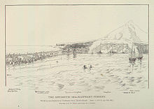
 Processing
elephant seals
on Heard Island ? a 19th-century scene
Processing
elephant seals
on Heard Island ? a 19th-century scene
Sealing
at Heard Island lasted from 1855 to 1910, during which time 67 sealing vessels are recorded visiting, nine of which were wrecked off the coast.
[34]
Relics that survive from that time include trypots, casks, hut ruins, graves and inscriptions. This caused the seal populations there to either become locally extinct or reduced to levels too low to exploit economically. Modern sealers visited from Cape Town in the 1920s.
[35]
Since then the populations have generally increased and are protected. Seals breeding on Heard include the
southern elephant seal
, the
Antarctic fur seal
and the
subantarctic fur seal
.
Leopard seals
visit regularly in winter to
haul-out
though they do not breed on the islands.
Crabeater
,
Ross
and
Weddell seals
are occasional visitors.
[36]
Birds
[
edit
]
Heard Island and the McDonald Islands are free from introduced predators and provide crucial breeding habitat in the middle of the vast Southern Ocean for a range of birds. The surrounding waters are important feeding areas for birds and some scavenging species also derive sustenance from their cohabitants on the islands. The islands have been identified by
BirdLife International
as an
Important Bird Area
because they support very large numbers of nesting seabirds.
[37]
Nineteen species of birds have been recorded as breeding on Heard Island
[38]
and the McDonald Islands, although recent volcanic activity at the McDonald Islands in the last decade is likely to have reduced vegetated and un-vegetated nesting areas.
[39]
Penguins are by far the most abundant birds on the islands, with four breeding species present, comprising
king
,
gentoo
,
macaroni
and
eastern rockhopper penguins
. The penguins mostly colonise the coastal tussock and grasslands of Heard Island, and have previously been recorded as occupying the flats and gullies on McDonald Island.
Other seabirds recorded as breeding at Heard Island include three species of albatross (
wandering
,
black-browed
and
light-mantled albatrosses
),
southern giant petrels
,
Cape petrels
, four species of burrowing petrels (
Antarctic
and
Fulmar prions
,
common
and
South Georgia diving petrels
),
Wilson's storm petrels
,
kelp gulls
,
subantarctic skuas
,
Antarctic terns
and the
Heard shag
.
[39]
Although not a true seabird, the Heard Island subspecies of the
black-faced sheathbill
also breeds on the island. Both the shag and the sheathbill are endemic to Heard Island.
A further 28 seabird species are recorded as either non-breeding visitors or have been noted during 'at-sea surveys' of the islands. All recorded breeding species, other than the Heard Island sheathbill, are listed marine species under the Australian Environmental Protection and Biodiversity Act (1999, four are listed as threatened species and five are listed migratory species. Under the EPBC Act a recovery plan has been made for albatrosses and giant petrels, which calls for ongoing population monitoring of the species found at HIMI, and at the time of preparing this plan a draft recovery plan has also been made for the
Heard Island cormorant (or shag)
and Antarctic tern.
The recorded populations of some seabird species found in the Reserve have shown marked change. The king penguin population is the best studied seabird species on Heard Island and has shown a dramatic increase since first recorded in 1947/48, with the population doubling every five years or so for more than 50 years.
A paper reviewing population data for the black-browed albatross between 1947 and 2000/01 suggested that the breeding population had increased to about three times that present in the late 1940s,
[40]
although a Convention for the Conservation of Antarctic Marine Living Resources CCAMLR) Working Group was cautious about the interpretation of the increasing trend given the disparate nature of the data,
[41]
as discussed in the paper. The discovery of a large, previously unknown, colony of Heard shags in 2000/01 at Cape Pillar raised the known breeding population from 200 pairs to over 1000 pairs.
[39]
The breeding population of southern giant petrels decreased by more than 50% between the early 1950s and the late 1980s.
Terrestrial, freshwater and coastal invertebrates
[
edit
]
Heard Island supports a relatively low number of terrestrial invertebrate species compared to other Southern Ocean islands, in parallel with the low species richness in the flora?that is, the island's isolation and limited ice-free area.
Endemism
is also generally low and the invertebrate fauna is exceptionally pristine with few, if any, (successful) human-induced introductions of alien species.
Two species, including the thrips
Apterothrips apteris
and the mite
Tyrophagus putrescentiae
are thought to be recent, possibly natural, introductions. An exotic species of earthworm
Dendrodrilus rubidus
was also collected in 1929 from a dump near Atlas Cove, and has recently been collected from a variety of habitats including wallows, streams and lakes on Heard Island.
The arthropods of Heard Island are comparatively well known with 54 species of
mite
and
tick
, one
spider
and eight
springtails
recorded. A study over summer at Atlas Cove in 1987/88 showed overall densities of up to 60 000 individual springtails per square metre in soil under stands of
Pringlea antiscorbutica
. Despite a few recent surveys, the non-arthropod invertebrate fauna of Heard Island remain poorly known.
Beetles and flies dominate Heard Island's known insect fauna, which comprises up to 21 species of ectoparasite (associated with birds and seals) and up to 13 free-living species. Approximately half of the free-living insects are habitat-specific, while the remainder are generalists found in a variety of habitats, being associated with either supralittoral or intertidal zones,
Poa cookii
and
Pringlea antiscorbutica
stands,
bryophytes
, lichen-covered rocks, exposed rock faces or the underside of rocks. There is a pronounced seasonality to the insect fauna, with densities in winter months dropping to a small percentage (between 0.75%) of the summer maximum. Distinct differences in relative abundances of species between habitats has also been shown, including a negative relationship between altitude and body size for Heard Island weevils.
The fauna of the freshwater pools, lakes, streams and mires found in the coastal areas of Heard Island are broadly similar to those on other subantarctic islands of the southern Indian Ocean. Many species reported from Heard Island are found elsewhere. Some sampling of freshwater fauna has been undertaken during recent expeditions and records to date indicate that the freshwater fauna includes a species of
Protista
, a gastrotrich, two species of
tardigrade
, at least four species of nematode, 26 species of rotifer, six species of annelid and 14 species of arthropod.
As with the other shore biota, the marine macro-invertebrate fauna of Heard Island is similar in composition and local distribution to other subantarctic islands, although relatively little is known about the Heard Island communities compared with the well-studied fauna of some other islands in the subantarctic region, such as
Macquarie
and Kerguelen.
Despite Heard Island's isolation, species richness is considered to be moderate, rather than depauperate, although the number of endemic species reported is low. The large macro-alga
Durvillaea antarctica
supports a diverse array of invertebrate taxa and may play an important role in transporting some of this fauna to Heard Island.
The rocky shores of Heard Island exhibit a clear demarcation between fauna of the lower kelp holdfast zone and the upper shore zone community, probably due to effects of desiccation, predation and freezing in the higher areas. The limpet
Nacella kerguelensis
is abundant in the lower part of the shore, being found on rock surfaces and on kelp holdfasts. Other common but less abundant species in this habitat include the chiton
Hemiarthrum setulosum
and the starfish
Anasterias mawsoni
. The amphipod
Hyale
sp. and the isopod
Cassidinopsis
sp. are closely associated with the kelp. Above the kelp holdfast zone, the littornid
Laevilitorina (Corneolitorina) heardensis
and the bivalve mollusc
Kidderia bicolor
are found in well-sheltered situations, and another bivalve
Gaimardia trapesina trapesina
has been recorded from immediately above the holdfast zone. Oligochaetes are also abundant in areas supporting porous and spongy layers of algal mat.
Retreat of Heard Island glaciers
[
edit
]
Heard Island is a heavily glaciated, subantarctic
volcanic island
located in the
Southern Ocean
, roughly 4,000 km (2,200 nmi) southwest of
Australia
. 80% of the island is covered in ice, with glaciers descending from 2,400 m (7,900 ft) to
sea level
.
[42]
Due to the steep
topography
of Heard Island, most of its glaciers are relatively thin (averaging only about 55 m (180 ft) in depth).
[43]
The presence of glaciers on Heard Island provides an excellent opportunity to measure the rate of glacial retreat as an indicator of climate change.
[44]
Available records show no apparent change in
glacier mass balance
between 1874 and 1929. Between 1949 and 1954, marked changes were observed to have occurred in the ice formations above 5000 feet on the southwestern slopes of Big Ben, possibly as a result of volcanic activity. By 1963, major recession was obvious below 2000 feet on almost all glaciers, and minor recession was evident as high as 5000 feet.
[45]
The coastal ice cliffs of
Brown
and
Stephenson
Glaciers, which in 1954 were over 50 feet high, had disappeared by 1963 when the glaciers terminated as much as 100 yards inland.
[45]
Baudissin Glacier
on the north coast, and
Vahsel Glacier
on the west coast have lost at least 100 and 200 vertical feet of ice, respectively.
[45]
Winston Glacier, which retreated approximately one mile between 1947 and 1963, appears to be a very sensitive indicator of glacier change on the island. The young moraines flanking
Winston Lagoon
show that Winston Glacier has lost at least 300 vertical feet of ice within a recent time period.
[45]
Jacka Glacier
on the east coast of
Laurens Peninsula
has also demonstrated marked recession since 1955.
[45]
Retreat of glacier fronts across Heard Island is evident when comparing
aerial photographs
taken in December 1947 with those taken on a return visit in early 1980.
[42]
[46]
Retreat of Heard Island glaciers is most dramatic on the eastern section of the island, where the
termini
of former
tidewater glaciers
are now located inland.
[42]
Glaciers on the northern and western coasts have narrowed significantly, while the area of glaciers and
ice caps
on Laurens Peninsula have shrunk by 30?65%.
[42]
[43]
During the time period between 1947 and 1988, the total area of Heard Island's glaciers decreased by 11%, from 288 square kilometres (111 sq mi) (roughly 79% of the total area of Heard Island) to only 257 square kilometres (99 sq mi).
[43]
A visit to the island in the spring of 2000 found that the Stephenson, Brown and Baudissin glaciers, among others, had retreated even further.
[43]
[46]
The terminus of Brown Glacier has retreated approximately
1.1 kilometres (
11
⁄
16
mi) since 1950.
[44]
The total ice-covered area of Brown Glacier is estimated to have decreased by roughly 29% between 1947 and 2004.
[46]
This degree of loss of glacier mass is consistent with the measured increase in temperature of 0.9 °C (1.6 °F) over that time span.
[46]
Possible causes of glacier recession on Heard Island include:
- Volcanic activity
- Southward movement of the
Antarctic Convergence
: such a movement conceivably might cause glacier retreat through a rise in sea and air temperatures
- Climatic change
The
Australian Antarctic Division
conducted an expedition to Heard Island during the
austral summer
of 2003?04. A small team of scientists spent two months on the island, conducting studies on
avian
and terrestrial biology and
glaciology
. Glaciologists conducted further research on the Brown Glacier, in an effort to determine whether glacial retreat is rapid or punctuated. Using a portable
echo sounder
, the team took measurements of the volume of the glacier. Monitoring of climatic conditions continued, with an emphasis on the impact of
Foehn winds
on glacier mass balance.
[47]
Based on the findings of that expedition, the rate of loss of glacier ice on Heard Island appears to be accelerating. Between 2000 and 2003, repeat
GPS
surface surveys
revealed that the rate of loss of ice in both the
ablation zone
and the
accumulation zone
of Brown Glacier was more than double average rate measured from 1947 to 2003. The increase in the rate of ice loss suggests that the glaciers of Heard Island are reacting to ongoing climate change, rather than approaching
dynamic equilibrium
.
[46]
The retreat of Heard Island's glaciers is expected to continue for the foreseeable future.
[42]
Administration and economy
[
edit
]
 Heard Island, 1929
The United Kingdom formally established its claim to Heard Island in 1910, marked by the raising of the Union Flag and the erection of a beacon by Captain Evensen, master of the
Mangoro
. Effective government, administration and control of Heard Island and the McDonald Islands was transferred to the Australian government on 26 December 1947 at the commencement of the first
Australian National Antarctic Research Expedition
(ANARE) to Heard Island, with a formal declaration that took place at Atlas Cove. The transfer was confirmed by an exchange of letters between the two governments on 19 December 1950.
[48]
The islands are a territory (Territory of Heard Island and McDonald Islands) of Australia administered from
Hobart
by the
Australian Antarctic Division
of the Australian
Department of Climate Change, Energy, the Environment and Water
. The administration of the territory is established in the
Heard Island and McDonald Islands Act 1953
, which places it under the jurisdiction of the
Supreme Court of the Australian Capital Territory
, with the non-criminal laws of the
Australian Capital Territory
and the criminal laws of
Jervis Bay Territory
applying to the Territory.
[49]
The islands are contained within a 65,000-square-kilometre (25,000 sq mi) marine reserve and are primarily visited for research, meaning that there is no permanent human habitation.
[1]
From 1947 until 1955 there were camps of visiting scientists on Heard Island (at
Atlas Cove
in the northwest, which was in 1969 again occupied by American scientists and expanded in 1971 by French scientists) and in 1971 on McDonald Island (at
Williams Bay
). Later expeditions used a temporary base at
Spit Bay
in the east, such as in 1988, 1992?93 and 2004?05.
The islands' only natural resource is fish; the Australian government allows limited fishing in the surrounding waters.
[1]
There are no active military installations or defence personnel on the islands. However, as part of "Operation Resolute", the
Royal Australian Navy
and
Australian Border Force
deploy
Cape
and
Armidale
-class
patrol boats to carry out civil maritime security operations in both Australian mainland and offshore territories including the Heard Island and McDonald Islands.
[50]
In part to carry out this mission, as of 2023, the Navy's
Armidale
-class boats are in the process of being replaced by larger
Arafura
-class offshore patrol vessels
.
[51]
Despite the lack of population, the islands have been assigned the
country code
HM in
ISO 3166-1
(
ISO 3166-2:HM
) and therefore the Internet
top-level domain
.hm
. The time zone of the islands is UTC+5.
[52]
See also
[
edit
]
References
[
edit
]
- ^
a
b
c
d
e
f
"Heard Island and McDonald Islands"
.
CIA World Factbook
. Retrieved
4 January
2009
.
- ^
UNESCO.
"Heard and McDonald Islands"
. Retrieved
31 January
2015
.
- ^
Commonwealth of Australia.
"About Heard Island ? Human Activities"
. Archived from
the original
on 18 October 2006
. Retrieved
21 October
2006
.
- ^
"Heard Island and McDonald Islands"
. ISO. 26 November 2018.
- ^
"Cocky Flies, Geoscience Australia"
. Archived from
the original
on 24 December 2008
. Retrieved
29 March
2016
.
- ^
"Distance Between Cities Places On Map Distance Calculator"
. distancefromto.net
. Retrieved
29 March
2016
.
- ^
"Frequently asked questions"
.
- ^
Goode, George Brown (1887) Fisheries and Fishery Industries of the United States, (Washington, DC: Government Printing Office, 1887).
- ^
a
b
Mills, William James (2003).
Exploring Polar Frontiers: A Historical Encyclopedia
. Bloomsbury Academic.
ISBN
9781576074220
.
- ^
"Fidelia Isthmus"
.
Australian Antarctic Gazetteer
. Retrieved
11 April
2023
.
- ^
Woehler, Eric (Spring 2004).
"Heard Island: a history of exploration"
.
Australian Antarctic Magazine
. Retrieved
11 April
2023
.
- ^
"Sealers, shipwrecks and survivors inspire new names on sub-Antarctic island"
. 2018.
- ^
Cerchi, Dan (1 August 2009).
"SIOE 2002: Heard I. & The McDonald Is"
.
www.cerchi.net
. Archived from
the original
on 26 April 2012.
- ^
"Gazetteer ? AADC Name Details ? Australian Antarctic Data Centre"
.
Australian Antarctic Data Centre
. Archived from
the original
on 6 April 2011
. Retrieved
29 March
2016
– via
Internet Archive
.
- ^
a
b
Thornton, Meg (1983).
Heard Island Expedition
. Spirit of Adventure Pty Ltd. pp. 28?29.
ISBN
0959256806
.
- ^
"Heard Island VK0EK DXpedition Team Has Arrived, Operation Hours Away"
.
American Radio Relay League
. 22 March 2016.
- ^
Temple, Phillip (1966).
The Sea and the Snow
. Cassell Australia.
- ^
"The Heard Island Feasibility Test"
.
University of Washington
. 2007.
- ^
"Heard Island Feasibility Test ? reception map"
.
University of Washington
. 2007.
- ^
Ken Green and Eric Woehler (2006).
Heard Island: Southern Ocean Sentinel
. Surrey Beatty & Sons. pp. 28?51.
- ^
Heard Island Geology
Archived
12 September 2009 at the
Wayback Machine
- ^
"Highest Mountains"
.
Geoscience Australia
. Retrieved
2 February
2012
.
- ^
Rare glimpse of erupting Australian sub-Antarctic volcano
. BBC News, 2 February 2016
- ^
Volcanic activity at McDonald Island ? Heard Island
. Australian Department of the Environment, Australian Antarctic Division, updated 1 March 2005
- ^
HIMI official website.
- ^
"Snowy Days (96.8)"
.
- ^
"Moyennes 1961?1990 Australie (Ile Heard)"
(in French)
. Retrieved
11 November
2019
.
- ^
"Meteo Climat stats for Ile Heard"
. Meteo Climat
. Retrieved
11 November
2019
.
- ^
Plants
. Australian Department of the Environment, Australian Antarctic Division. Updated 28 February 2005.
- ^
Environment.
"Heard Island and McDonald Islands Marine Reserve Management Plan 2005"
.
www.legislation.gov.au
. Retrieved
7 April
2020
.
- ^
Turner, P. A. M.; Scott, J. J.; Rozefelds, A. C. (February 2006).
"Probable long distance dispersal of Leptinella plumosa Hook.f. to Heard Island: habitat, status and discussion of its arrival"
(PDF)
.
Polar Biology
.
29
(3): 160?168.
doi
:
10.1007/s00300-005-0035-z
.
ISSN
0722-4060
.
S2CID
26445494
.
- ^
Part 3: A Description of the Heard Island and McDonald Islands Marine Reserve
. Heard Island and McDonald Islands Marine Reserve Management Plan. retrieved 5 February 2016.
- ^
"Southern Indian Ocean Islands tundra"
.
Terrestrial Ecoregions
. World Wildlife Fund.
- ^
R.K.Headland (Ed.)
Historical Antarctic Sealing Industry
, Scott Polar Research Institute (University of Cambridge), 2018, p. 167.
ISBN
978-0-901021-26-7
- ^
Headland, p. 167
- ^
"Seals"
.
Heard Island and McDonald Islands: Seals
. Department of Sustainability, Environment, Water, Population and Communities, Australia
. Retrieved
23 February
2011
.
- ^
BirdLife International. (2011). Important Bird Areas factsheet: Heard and McDonald Islands. Downloaded from
http://www.birdlife.org
on 2011-12-23.
- ^
Woehler, E.J. & Croxall, J.P. 1991. ‘Status and conservation of the seabirds of Heard Island and the McDonald Islands’, in Seabird ? status and conservation: a supplement, ICBP Technical Publication 11. International Council for Bird Preservation, Cambridge. pp 263?277.
- ^
a
b
c
Woehler, E.J. (2006). ‘Status and trends of the seabirds of Heard Island, 2000’, in Heard Island: Southern Ocean Sentinel. ed. Green, K. & Woehler, E. Surrey Beattie.
- ^
Woehler, E. J.; Auman, H. J.; Riddle, M. J. (2002). "Long-term population increase of black-browed albatrosses
Thalassarche melanophrys
at Heard Island, 1947/1948?2000/2001".
Polar Biology
.
25
(12): 921?927.
doi
:
10.1007/s00300-002-0436-1
.
S2CID
2425658
.
- ^
SC?CAMLR 2002. Report of the Working Group on Fish Stock Assessment. Report of the Twenty-First Meeting of the Scientific Committee for the Conservation of Antarctic Marine Living Resources, Hobart, Australia.
- ^
a
b
c
d
e
Ian F. Allison & Peter L. Keage (1986). "Recent changes in the glaciers of Heard Island".
Polar Record
.
23
(144): 255?272.
doi
:
10.1017/S0032247400007099
.
S2CID
130086301
.
- ^
a
b
c
d
Andrew Ruddell (25 May 2010).
"Our subantarctic glaciers: why are they retreating?"
. Glaciology Program, Antarctic CRC and AAD. Archived from
the original
on 2 October 2009
. Retrieved
5 June
2010
.
- ^
a
b
"
'Big brother' monitors glacial retreat in the sub-Antarctic"
. Kingston, Tasmania, Australia: Australian Antarctic Division. 8 October 2008. Archived from
the original
on 30 September 2009
. Retrieved
7 June
2010
.
- ^
a
b
c
d
e
G.M. Budd; P.J. Stephenson (1970).
"Recent glacier retreat on Heard Island"
(PDF)
.
International Association for Scientific Hydrology
.
86
: 449?458
. Retrieved
7 June
2010
.
- ^
a
b
c
d
e
Douglas E. Thost; Martin Truffer (February 2008).
"Glacier Recession on Heard Island, Southern Indian Ocean"
.
Arctic, Antarctic, and Alpine Research
.
40
(1): 199?214.
doi
:
10.1657/1523-0430(06-084)[THOST]2.0.CO;2
.
S2CID
130245283
.
- ^
"Australian Research Expeditions"
. Kingston, Tasmania, Australia:
Department of the Environment, Water, Heritage and the Arts
,
Australian Antarctic Division
, Territories, Environment and Treaties Section
. Retrieved
7 June
2010
.
- ^
"Heard Island Officially Australian"
.
The Daily News, Perth WA
. 9 February 1951
. Retrieved
25 January
2024
.
- ^
"Heard Island and McDonald Islands Act 1953"
.
Federal Register of Legislation
. Australian Government
. Retrieved
7 May
2018
.
- ^
"Operation Resolute"
.
Australian Government - Defence
. Retrieved
20 August
2023
.
- ^
"Arafura Class OPV"
.
Royal Australian Navy
. Retrieved
20 August
2023
.
- ^
"Heard Island and McDonald Islands :: Time Zones"
. timegenie.com
. Retrieved
29 March
2016
.
Further reading
[
edit
]
- Commonwealth of Australia (2014).
Heard Island and McDonald Islands Marine Reserve Management Plan 2014?2024
, Department of the Environment, Canberra.
ISBN
978-1876934-255
. Available at
http://heardisland.antarctica.gov.au/
- Australian Government. (2005)
Heard Island and McDonald Islands Marine Reserve Management Plan
. Australian Antarctic Division: Kingston (Tas).
ISBN
1-876934-08-5
.
- Green, Ken and Woehler Eric (eds). (2006)
Heard Island: Southern Ocean Sentinel
. Chipping Norton: Surrey Beatty and Sons.
ISBN
9780949324986
.
- Scholes, Arthur. (1949)
Fourteen men; story of the Australian Antarctic Expedition to Heard Island
. Melbourne: F.W. Cheshire.
- Smith, Jeremy. (1986)
Specks in the Southern Ocean
. Armidale: University of New England Press.
ISBN
0-85834-615-X
.
- LeMasurier, W. E. and Thomson, J. W. (eds.). (1990)
Volcanoes of the Antarctic Plate and Southern Oceans
.
American Geophysical Union
.
ISBN
0-87590-172-7
.
External links
[
edit
]
Links to related articles
|
|---|
|
|---|
| States
| | |
|---|
| Territories
| Internal
territories
| |
|---|
External
territories
| |
|---|
|
|---|
|
|
|---|
| New South Wales
| |
|---|
| Northern Territory
| |
|---|
| Queensland
| |
|---|
| South Australia
| |
|---|
| Tasmania
| |
|---|
| Victoria
| |
|---|
| Western Australia
| |
|---|
| External territories
| |
|---|
|
|
|
|---|
| International
| |
|---|
| National
| |
|---|
| Geographic
| |
|---|
| People
| |
|---|
53°06′00″S
73°31′00″E
/
53.10000°S 73.51667°E
/
-53.10000; 73.51667
