| Name
|
Area
|
Note/
coordinates
|
Image
|
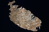
| Malta Island
|
246 km
2
[2]
|
35°52′55″N
14°26′57″E
/
35.88182°N 14.44908°E
/
35.88182; 14.44908
(
Malta
)
[3]
|
|
Gozo
(Għawdex)
|
67.1 km
2
[2]
|
36°02′58″N
14°15′00″E
/
36.04944°N 14.25°E
/
36.04944; 14.25
(
Gozo
)
[3]
|

|
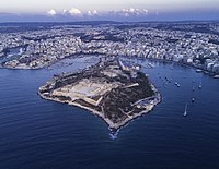
Comino
(Kemmuna)
|
2.8 km
2
[2]
|
36°00′44″N
14°20′12″E
/
36.01226°N 14.33669°E
/
36.01226; 14.33669
(
Comino
)
[3]
|

|
Manoel Island
(Il-G?ira Manoel)
|
0.3 km
2
|
35°54′14″N
14°30′07″E
/
35.904°N 14.502°E
/
35.904; 14.502
(
Manoel Island
)
|
|
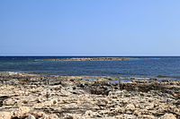
St Paul's Islands
(Il-G?ejjer ta' San Pawl)
|
0.101 km
2
[2]
|
35°57′55″N
14°24′2″E
/
35.96528°N 14.40056°E
/
35.96528; 14.40056
(
St Paul's Island
)
|

|
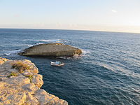
Cominotto
(Kemmunett)
|
0.099 km
2
[4]
|
36°00′49″N
14°19′10″E
/
36.01361°N 14.31944°E
/
36.01361; 14.31944
(
Kemmunett
)
[3]
|
|
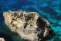
| Filfla
(and Filfoletta)
|
0.020 km
2
[2]
|
35°47′15″N
14°24′37″E
/
35.78750°N 14.41028°E
/
35.78750; 14.41028
(
Filfla
)
|

|
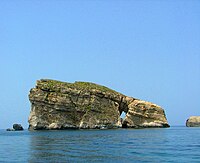
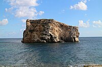
Fungus Rock
(Il-?ebla tal-?eneral)
|
0.007 km
2
[2]
|
36°02′49″N
14°11′20″E
/
36.04694°N 14.18889°E
/
36.04694; 14.18889
(
Fungus Rock
)
[3]
|
|
Ħalfa Rock
(Il-?ebla tal-Ħalfa)
|
0.0050 km
2
[5]
[6]
|
36°01′45″N
14°19′51″E
/
36.02917°N 14.33083°E
/
36.02917; 14.33083
(
?ebel tal-Ħalfa
)
[3]
Situated near Gozo. In the island there is 4 to 5 metres deep water rock pool just 2 metres above sea level, possibly man made due to its perfectly round shape. There is also an underground fresh water system which emerges from a small cave. Most of the plants occurs on the western part of the island.
Crucianella rupestris
,
Anthrocnemum macrostachyum
,
Lygeum spartum
,
Convolvulus oleifolius
,
Thymbra capitata
,
Teucrium fruticans
,
Allium melitense
,
Anacamptis urvilleana
,
Bromus madritensis
,
Capparis spinosa
,
Echium parviflorum
,
Pallenis spinosa
,
Plantago lagopus
,
Trachynia distachya
,
Urginea pancration
.
[4]
|
|
Old Battery's Rock
(?ebla ta' taħt il-Batterija)
|
|
Situated on the southeast of Comino. Flora consisted of 22 individuals of
Inula crithmoides
(2010).
[4]
|
|
Lantern Point Rock
(?ebla Tal-Ponta Rqiqa)
|
|
Situated near Comino.
[4]
Live here two species of plants:
Limonium melitense
and
Inula crithmoides
. It has a height of 7 meters.
[7]
|
|
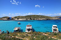
| Large
Blue Lagoon Rock
|
|
In island, there is a cave. Species of plants:
Hypericium aegypticum
,
Daucus carota
,
Convolvulus oleifolius
,
Darniella melitensis
,
Arthrocnemum macrostachyum
,
Senecio bicolor
.
[4]
|

|
| Small
Blue Lagoon Rocks
|
|
Situated between Large Blue Lagoon and Cominotto. Species of plants:
Arthrocnemum macrostachyum
,
Daucus carota
,
Lygeum spartum
,
Lavatera arborea
.
[4]
|

|
Devil's End Rock
(Il-?ebla tax-Xifer l-Infern)
[4]
|
|
Situated near main island, Delimara point.
|
|
| Għallis Rocks
[4]
|
|
35°57′13″N
14°26′46″E
/
35.95361°N 14.44611°E
/
35.95361; 14.44611
(
Għallis Rocks
)
[3]
|
|
Ta?-?awl Rock
(Il-?ebla ta?-?awl)
|
|
36°01′34″N
14°18′57″E
/
36.02611°N 14.31583°E
/
36.02611; 14.31583
(
Il-?ebel ta?-?awl
)
[3]
Situated near Gozo. The flora consisted of
Lygeum spartum
,
Asphodelus aestivus
,
Crithmum maritimum
,
Cichorium spinosum
,
Crucianella rupestrisis
,
Opuntia
,
Thymbra capitata
,
Euphorbia melitensis
,
Foeniculum vulgare
,
Allium commutatum
,
Allium lajoconoi
,
Bromus madritensis
,
Capparis spinosa
,
Gynandriris sisirynchium
,
Pistacia lentiscus
,
Phagnalon graceum
,
Sedum litoreum
,
Sonchus tenerrimus
,
Trachynia distachya
,
Valantia muralis
.
[4]
|
|
Cheirolophus Rock
(Ħa?ra tas-Sajjetta)
|
|
Situated near main island. It has a height of 9 to 12 meters high at its highest point. Species of plants:
Darniella melitensis
,
Crithmum maritimum
,
Cheirolophus crassifolius
,
Inula crithmoides
,
Limonium virgatum
,
Daucus carota
,
Cheirolophus crassifolius
.
[4]
|
|
| Barbaganni Rock
|
|
Situated near Gozo. No soil exists on the islet because island is inundated by water wave action during rough weather. The flora consisted of only 14 individuals of
Inula crithmoides
(2010).
[4]
|
|
Crocodile Rock & Bear rocks
(Il-?ebla tal-Baqra u il-?ebel tal-Orsijiet)
|
|
Near Gozo, three rocks in total.
[4]
|
|
Qawra Point
(Ta' Fra Ben islet, Il-Ponta jew Ras il- Qawra)
|
|
Situated near main island. The western part is littered with small boulders, while much of the vegetation occurs in the middle part of the islet. In island there is sea cave occurs as a big hole in the middle of the islet. Species of plants:
Arthrocnemum macrostachyum
,
Anthemis urvilleana
,
Inula crithmoides
,
Lotus cystisoides
,
Limonium
,
Sporbolus pungens
.
[4]
|

|
Comino Cliff Face Rock
(Ta' Taħt il-Mazz Rock)
|
|
Situated near Comino. The island is very steep - cliffs. The majority of species of plants occur on its west side, while only one species of plant inhabits its east side. Species of plants:
Matthiola incana
,
Inula crithmoides
,
Darniella melitensis
,
Daucus carota
,
Limonium melitensis
,
Anthyllis hermanniae
,
Pistacia lentiscus
.
[4]
|
|
Xrobb l-Għa?in Rock
(It-Taqtiegħa)
[4]
|
|
|
|
Fessej Rock
(Il-?ebla tal-Fessej)
[4]
[8]
|
|
|

|
Għemieri Rocks
(L-iskolli tal-Għemieri)
[4]
|
|
|
|
Ħnejja Rocks
(?ebel tal-Ħnejja)
[4]
|
|
|
|
White Rock / Blue Islets
(Rocks)
(?ebla tal-Għar Qawqla)
[4]
|
|
36°04′27″N
14°15′45″E
/
36.07417°N 14.26250°E
/
36.07417; 14.26250
(
Għar Qawqla
)
|

|
