Overview of the geography of Kazakhstan
 Detailed map of Kazakhstan
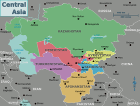
Kazakhstan
is located in
Central Asia
(with 4% of the country (108,996 km2) in
Eastern Europe
[1]
). With an area of about 2,724,900 square kilometers (1,052,100 sq mi)
Kazakhstan
is more than twice the combined size of the other four Central Asian states and 60% larger than
Alaska
. The country borders
Turkmenistan
,
Uzbekistan
, and
Kyrgyzstan
to the south;
Russia
to the north; Russia and the
Caspian Sea
to the west; and China's
Xinjiang Uygur Autonomous Region
to the east.
Borders, Lands and Waters
[
edit
]
Source:
[2]
Borders
[
edit
]
Russia (7,591 km)
China (1,783 km)
Kyrgyzstan (1,242 km)
Uzbekistan (2,351 km)
Turkmenistan (426 km)
Total length: 13,200 km.
Lands
[
edit
]
More than three-quarters (75%) of the country, including the entire west and most of the south, is either semidesert (33.2 percent) or desert (44 percent).
Deserts
: 44% (1,198,956 km2)
Semi-Deserts
: 14% (381,486 km2)
Steppes
: 26% (708,474 km2)
Forests
: only 5.5% (149,870 km2)
Deserts + Semi-Deserts: 58% (1,580,442 km2)
Deserts + Semi-Deserts + Steppes: 84% (2,288,916 km2)
Waters (Rivers and Lakes)
[
edit
]
Northeastern of the
Caspian Sea
Part of
Aral Sea
48,000 large and small lakes such as
Balkhash Lake
,
Lake Zaysan
and
Lake Alakol
.
8,500 rivers
Topography and drainage
[
edit
]
 In the
steppes
of Central Asia (
Akmola Region
)
In the
steppes
of Central Asia (
Akmola Region
)
There is considerable topographical variation within Kazakhstan. The highest point is the top of the mountain
Khan Tengri
, on the Kyrgyz border in the
Tian Shan
range, with an elevation of 7,010 m (23,000 ft) above sea level; the lowest point is the bottom of the
Karagiye
depression at 132 m (433 ft) below sea level, in the
Mangystau
province east of the
Caspian Sea
. Most of the country lies at between 200?300 m (660?980 ft) above sea level, but Kazakhstan's Caspian shore includes some of the lowest elevations on Earth. The peak Khan Tengri in the Tian Shan Mountains (and on the border with
Kyrgyzstan
and
China
) is Kazakhstan highest elevation at 6,995 m (22,949 ft) (7,010 m (23,000 ft) with ice cap).
Many of the peaks of the
Altay
and Tien Shan ranges are covered with snow, year-round, and their runoff is the source for most of Kazakhstan's freshwater rivers, streams, and lakes. Kazakhstan's
Almaty
region is also home to the
Mynzhylky mountain plateau
.
Except for the
Tobol
,
Ishim
, and
Irtysh
rivers (the Kazakh names for which are, respectively, Tobyl, Esil, and Ertis), portions of which flow through Kazakhstan, all of Kazakhstan's rivers and streams are part of landlocked systems. They either flow into isolated bodies of water such as the Caspian Sea or simply disappear into the steppes and deserts of central and southern Kazakhstan. Many rivers, streams, and lakes are seasonal, evaporating in summer. The three largest bodies of water are
Lake Balkhash
, a partially fresh, partially saline lake in the east, near
Almaty
, the Caspian Sea, and the
Aral Sea
, all of which lie partially within Kazakhstan.
Some 9.4 percent of Kazakhstan's land is mixed
prairie
and
forest
or treeless prairie, primarily in the north or in the basin of the
Ural River
in the west. More than three-quarters of the country, including the entire west and most of the south, is either semidesert (33.2 percent) or desert (44 percent). The terrain in these regions is bare, eroded, broken
uplands
(
Upland and lowland
), with sand dunes in the
Qizilqum
("The Red Sands"; in the Russian form,
Kyzylkum
),
Moyunqum
(in the Russian form, Muyunkum) and
Barsuki
deserts, which occupy south-central Kazakhstan.
Climate
[
edit
]
 Kazakhstan map of Koppen climate classification.
The climate of Kazakhstan consists of mostly continental, semi-arid, and cold desert climates. In summer the temperatures average more than 30 °C (86 °F) and in winter average ?9 °C (15.8 °F).
[3]
The climatic charts seen below are some noteworthy examples of the country's differing climates, taken from two contrasting cities (with their respective tables) representing two different parts of the country; Aktau and the Caspian Sea shore on the country's west having a distinct
cold desert climate
and
cold semi-arid climate
, while Petropavl features a climate typical to the rest of the country; an extreme variation of the
humid continental climate
known for its uneven rainfall distribution and drastic temperature ranges between seasons.
Despite the nation's relatively low precipitation rates and mostly arid geography, spring floods brought on by occasional heavy rainfall and snowmelt are not unusual in the northern and central regions of the country. In April 2017, following a winter with snow volumes 60 percent above average, heavy rains resulted in widespread damage and temporarily displaced thousands of people.
[4]
| Aktau
(
Caspian Sea
shore)
|
|---|
| Climate chart (
explanation
)
|
|---|
J
|
F
|
M
|
A
|
M
|
J
|
J
|
A
|
S
|
O
|
N
|
D
|
|
|
|
|
|
|
|
|
|
|
|
|
| ?
Average max. and min. temperatures in °C
|
| ?
Precipitation totals in mm
| | Source: Svali.ru
[5]
|
|
| Imperial conversion
|
|---|
| J
| F
| M
| A
| M
| J
| J
| A
| S
| O
| N
| D
|
|
|
|
|
|
|
|
|
|
|
|
|
| ?
Average max. and min. temperatures in °F
|
| ?
Precipitation totals in inches
|
|
| Petropavl
(
North Kazakhstan
)
|
|---|
| Climate chart (
explanation
)
|
|---|
J
|
F
|
M
|
A
|
M
|
J
|
J
|
A
|
S
|
O
|
N
|
D
|
|
|
|
|
|
|
|
|
|
|
|
|
| ?
Average max. and min. temperatures in °C
|
| ?
Precipitation totals in mm
| | Source: Pogoda.ru.net
[6]
|
|
| Imperial conversion
|
|---|
| J
| F
| M
| A
| M
| J
| J
| A
| S
| O
| N
| D
|
|
|
|
|
|
|
|
|
|
|
|
|
| ?
Average max. and min. temperatures in °F
|
| ?
Precipitation totals in inches
|
|
Average daily maximum and minimum temperatures for large cities in Kazakhstan
[7]
| Location
|
July (°C)
|
July (°F)
|
January (°C)
|
January (°F)
|
| Almaty
|
30/18
|
86/64
|
0/?8
|
33/17
|
| Shymkent
|
32/17
|
91/66
|
4/?4
|
39/23
|
| Karaganda
|
27/14
|
80/57
|
?8/?17
|
16/1
|
| Astana
|
27/15
|
80/59
|
?10/?18
|
14/?1
|
| Pavlodar
|
28/15
|
82/59
|
?11/?20
|
12/?5
|
| Aktobe
|
30/15
|
86/61
|
?8/?16
|
17/2
|
Environmental problems
[
edit
]
 Portions of Kazakhstan (top) and Kyrgyzstan at the bottom. The lake at the top of the image is Lake Balkhash.
The environment of
Kazakhstan
has been badly damaged by human activity. Most of the water in Kazakhstan is polluted by industrial effluents, pesticide and fertilizer residue, and, in some places, radioactive elements. The most visible damage has been to the
Aral Sea
, which as recently as the 1970s was larger than any of the
Great Lakes
of
North America
save
Lake Superior
. The sea began to shrink rapidly when sharply increased irrigation and other demands on the only significant tributaries, the
Syr Darya
and the
Amu Darya
(the latter reaching the Aral from neighboring Uzbekistan), all but eliminated inflow. During the Soviet Era, Kazakhstan received water from
Tajikistan
and
Kyrgyzstan
, and
Uzbekistan
,
Turkmenistan
, and Kazakhstan provided oil and gas for these two nations in return. However, after the
collapse of the USSR
this system had collapsed and no plan to replace this system has been put in place. According to research conducted by the
International Crisis Group
, there is little political will to solve this problem despite Central Asia's need for mutual resource-sharing.
[8]
By 1993 the Aral Sea had lost an estimated 60 percent of its volume, in the process breaking into three unconnected segments. Increasing salinity and reduced habitat have killed the Aral Sea's fish, hence destroying its once-active fishing industry, and the receding shoreline has left the former port of Aral'sk more than seventy kilometers from the water's edge. The depletion of this large body of water has increased temperature variations in the region, which in turn have affected agriculture. A much greater agricultural impact, however, has come from the salt- and pesticide-laden soil that the wind is known to carry as far away as the
Himalaya Mountains
and the
Pacific Ocean
. Deposition of this heavily saline soil on nearby fields effectively sterilizes them. Evidence suggests that salts, pesticides, and residues of chemical fertilizers are also adversely affecting human life around the former Aral Sea; infant mortality in the region approaches 10 percent compared with the national rate of 2.7 percent in 1991.
By contrast, the water level of the Caspian Sea has been rising steadily since 1978 for reasons that scientists have not been able to explain fully. At the northern end of the sea, more than 10,000 square kilometres of land in
Atyrau Province
have been flooded. Experts estimate that if current rates of increase persist, the coastal city of Atyrau, eighty-eight other population centers, and many of Kazakhstan's Caspian oil fields could be submerged soon.
Wind erosion has also affected the northern and central parts of the republic because of the introduction of wide-scale dryland wheat farming. During the 1950s and 1960s, much soil was lost when vast tracts of Kazakhstan's prairies were plowed under as part of Khrushchev's Virgin Lands agricultural project. By the mid-1990s, an estimated 60 percent of the republic's pastureland was in various stages of
desertification
.
Industrial pollution is a bigger concern in Kazakhstan's manufacturing cities, where aging factories pump huge quantities of unfiltered pollutants into the air and groundwater. The former capital, Almaty, is particularly threatened, in part because of the postindependence boom in private automobile ownership.
The gravest environmental threat to Kazakhstan comes from radiation, especially in the
Semey
(Semipalatinsk) region of the northeast, where the
Soviet Union
tested almost 500 nuclear weapons, 116 of them above ground. Often, such tests were conducted without evacuating or even alerting the local population. Although nuclear testing was halted in 1990, radiation poisoning, birth defects, severe anemia, and
leukemia
are thought to be very common in the area.
[9]
With some conspicuous exceptions, lip service has been the primary official response to Kazakhstan's ecological problems. In February 1989, opposition to Soviet nuclear testing and its ill effects in Kazakhstan led to the creation of one of the republic's largest and most influential grass-roots movements, Nevada-Semipalatinsk, which was founded by Kazak poet and public figure
Olzhas Suleymenov
. In the first week of the movement's existence, Nevada-Semipalatinsk gathered more than two million signatures from Kazakhstanis of all ethnic groups on a petition to
Mikhail Gorbachev
demanding the end of nuclear testing in Kazakhstan. After a year of demonstrations and protests, the test ban took effect in 1990. It remained in force in 1996, although in 1995 at least one unexploded device reportedly was still in position near Semey.
Once its major ecological objective was achieved, Nevada-Semipalatinsk made various attempts to broaden into a more general political movement; it has not pursued a broad ecological or "green" agenda. A very small green party, Tabigat, made common cause with the political opposition in the parliament of 1994.
The government has established a Ministry of Ecology and Bioresources, with a separate administration for
radioecology
, but the ministry's programs are underfunded and given low priority. In 1994 only 23 percent of budgeted funds were actually allotted to environmental programs. Many official meetings and conferences are held (more than 300 have been devoted to the problem of the Aral Sea alone), but few practical programs have gone into operation. In 1994 the
World Bank
, the
International Monetary Fund
(IMF), and the
United States Environmental Protection Agency
agreed to give Kazakhstan $62 million to help the country overcome ecological problems.
- Natural hazards
- Earthquakes
in the south, and
mud slides
around
Almaty
- Environment?current issues
- Radioactive or toxic chemical sites associated with its former defense industries and test ranges are found throughout the country and pose health risks for human beings and animals; industrial pollution is severe in some cities; because the two main rivers which flowed into the Aral Sea have been diverted for irrigation, it is drying up and leaving behind a harmful layer of chemical pesticides and natural salts; these substances are then picked up by the wind and blown into noxious dust storms; pollution in the Caspian Sea;
soil pollution
from overuse of agricultural chemicals and salination from poor infrastructure and wasteful irrigation practices
- Environment?international agreements
-
Area and boundaries
[
edit
]
 With land area of 2.6 million km2, Kazakhstan is the largest country in Central Asia
According to
CIA World Factbook
estimates:
[10]
- Area
-
- Total: 2,724,900 km
2
(1,052,100 sq mi)
- Land: 2,699,700 km
2
(1,042,400 sq mi)
- Water: 25,200 km
2
(9,700 sq mi)
- Land boundaries
-
- Total: 13,364 kilometres (8,304 mi)
- Border countries: the
People's Republic of China
(to the southeast) 1,765 kilometres (1,097 mi),
Kyrgyzstan
(to the southeast) 1,212 kilometres (753 mi),
Russia
(to the north) 7,644 kilometres (4,750 mi),
Turkmenistan
(to the southwest) 413 kilometres (257 mi),
Uzbekistan
(to the south) 2,330 kilometres (1,450 mi).
- Coastline
- 0 km (0 mi); the country is landlocked, but does border the
Caspian Sea
(1,894 km/1,176 mi).
- Maritime claims
- None (landlocked)
- Elevation extremes
-
Land use
[
edit
]
According to
CIA World Factbook
estimates:
[10]
- Agricultural land
77.4% (2011)
-
- Irrigated land
(2012)
-
Water resources
[
edit
]
- Total renewable water resources
-
- Freshwater withdrawal (domestic/industrial/agricultural)
-
- Total: 21.14 km
3
/yr (4%/30%/66%)
- Per capita: 1,304 m
3
/yr (2010)
Deserts
[
edit
]
- Aral Karakum Desert
40,000 km2
- Aralkum Desert
- Barsuki Desert
- Betpak-Dala
75,000 km2
- Kyzylkum Desert
298,000 km2
- Moiynkum Desert
37,500 km2
- Ryn Desert
40,000 km2
- Saryesik-Atyrau Desert
- Taukum
10,000 km2
- Ustyurt Plateau
200,000 km2
References
[
edit
]
External links
[
edit
]
|
|---|
| Sovereign states
| |
|---|
States with limited
recognition
| |
|---|
Dependencies and
other entities
| |
|---|
| Other entities
| |
|---|
|
|---|
| Sovereign states
| |
|---|
States with limited
recognition
| |
|---|
Dependencies and
other entities
| |
|---|
| Other entities
| |
|---|
