From Wikipedia, the free encyclopedia
Geographical features of East Timor
Geography of East Timor
 |
| Continent
| Asia
|
|---|
| Region
| Southeast Asia
|
|---|
| Coordinates
| 8°50′S
125°55′E
/
8.833°S 125.917°E
/
-8.833; 125.917
|
|---|
| Area
| Ranked 154th
|
|---|
| ? Total
| 14,919 km
2
(5,760 sq mi)
|
|---|
| ? Land
| 100%
|
|---|
| ? Water
| 0%
|
|---|
| Coastline
| 706 km (439 mi)
|
|---|
| Borders
| Indonesia
: 253 km (157 mi)
|
|---|
| Highest point
| Tatamailau
(2,963 m or 9,721 ft)
|
|---|
| Lowest point
| Timor Sea
,
Savu Sea
, and
Banda Sea
0 m (0 ft)
|
|---|
| Longest river
| Loes River
80 km (50 mi)
|
|---|
| Largest lake
| Ira Lalaro
1.9 km
2
(1 sq mi)
|
|---|
| Climate
| Tropical
|
|---|
| Terrain
| Mountainous and rugged
|
|---|
| Natural resources
| Gold
,
petroleum
,
natural gas
,
manganese
,
marble
|
|---|
| Natural hazards
| Landslides
are common;
earthquakes
; and
tsunamis
.
|
|---|
| Environmental issues
| deforestation
and soil
erosion
|
|---|
| Exclusive economic zone
| 70,326 km
2
(27,153 sq mi)
|
|---|
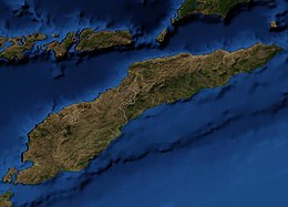
 Detailed map of East Timor
East Timor
includes the mountainous eastern half of
Timor
, the
Ocussi-Ambeno
region on the northwest portion of the island of Timor, and the islands of
Atauro
and
Jaco
. The country is located northwest of
Australia
in the
Lesser Sunda Islands
at the eastern end of the
Indonesian Archipelago
. 'Timor' is a Portuguese derivation of 'Timor', the
Malay
word for "
Orient
"; the island of Timor is part of the
Malay Archipelago
and is the largest and easternmost of the Lesser Sunda Islands. East Timor is the only Asian nation to lie entirely within the Southern Hemisphere.
[
citation needed
]
The
Loes River
is the longest with a length of 80 km (50 mi). This river system covers an area of 2,184 km
2
(843 sq mi). It is a small country with a land size of 14,919 km
2
(5,760 sq mi). The
exclusive economic zone
is 70,326 km
2
(27,153 sq mi).
[1]
Statistics
[
edit
]
- Area
-
- Total:
14,874
km
2
- Land: 14,874 km
2
- Water: 0 km
2
- Land boundaries
-
- Total: 2,538 km (1,577 mi)
- Border countries:
Indonesia
(253 km or 157 mi)
- Coastline
- 706 km (439 mi)
- Maritime claims
-
Elevation extremes
[
edit
]
- Natural resources
- Gold
,
petroleum
,
natural gas
,
manganese
,
marble
- Land use
-
- Arable land: 10.1%
- Permanent crops: 4.9%
- Permanent pasture: 10.1%
- Forest: 49.1%
- Other: 25.8% (2011)
- Irrigated land
- 346.5 km
2
(134 sq mi) (2003)
Climate
[
edit
]
- The islands have a
tropical savanna climate
, bordering on a
tropical monsoon climate
; hot and humid with distinct rainy and dry seasons. Tropical cyclones do occur along with floods.
| Climate data for Dili (1914-1963)
|
| Month
|
Jan
|
Feb
|
Mar
|
Apr
|
May
|
Jun
|
Jul
|
Aug
|
Sep
|
Oct
|
Nov
|
Dec
|
Year
|
| Record high °C (°F)
|
36.0
(96.8)
|
35.5
(95.9)
|
36.6
(97.9)
|
36.0
(96.8)
|
35.7
(96.3)
|
36.5
(97.7)
|
34.1
(93.4)
|
35.0
(95.0)
|
34.0
(93.2)
|
34.5
(94.1)
|
36.0
(96.8)
|
35.5
(95.9)
|
36.6
(97.9)
|
| Mean daily maximum °C (°F)
|
31.3
(88.3)
|
31.1
(88.0)
|
31.2
(88.2)
|
31.5
(88.7)
|
31.3
(88.3)
|
30.7
(87.3)
|
30.2
(86.4)
|
30.1
(86.2)
|
30.3
(86.5)
|
30.5
(86.9)
|
31.4
(88.5)
|
31.1
(88.0)
|
30.9
(87.6)
|
| Daily mean °C (°F)
|
27.7
(81.9)
|
27.6
(81.7)
|
27.4
(81.3)
|
27.4
(81.3)
|
27.0
(80.6)
|
26.8
(80.2)
|
25.5
(77.9)
|
25.1
(77.2)
|
25.4
(77.7)
|
26.0
(78.8)
|
27.2
(81.0)
|
27.4
(81.3)
|
26.6
(79.9)
|
| Mean daily minimum °C (°F)
|
24.1
(75.4)
|
24.1
(75.4)
|
23.5
(74.3)
|
23.5
(74.3)
|
22.8
(73.0)
|
21.9
(71.4)
|
20.8
(69.4)
|
20.1
(68.2)
|
20.5
(68.9)
|
21.5
(70.7)
|
23.0
(73.4)
|
23.6
(74.5)
|
22.4
(72.3)
|
| Record low °C (°F)
|
19.0
(66.2)
|
16.2
(61.2)
|
16.5
(61.7)
|
18.2
(64.8)
|
13.2
(55.8)
|
14.5
(58.1)
|
12.4
(54.3)
|
11.8
(53.2)
|
13.4
(56.1)
|
16.1
(61.0)
|
18.0
(64.4)
|
16.7
(62.1)
|
11.8
(53.2)
|
| Average rainfall mm (inches)
|
139.5
(5.49)
|
138.7
(5.46)
|
132.7
(5.22)
|
104.3
(4.11)
|
74.9
(2.95)
|
58.4
(2.30)
|
20.1
(0.79)
|
12.1
(0.48)
|
9.0
(0.35)
|
12.8
(0.50)
|
61.4
(2.42)
|
144.9
(5.70)
|
908.8
(35.77)
|
| Average rainy days
(≥ 1.0 mm)
|
13
|
13
|
11
|
9
|
6
|
4
|
3
|
1
|
1
|
2
|
6
|
11
|
80
|
| Average
relative humidity
(%)
|
80
|
82
|
80
|
77
|
75
|
72
|
71
|
70
|
71
|
72
|
73
|
77
|
75
|
| Mean monthly
sunshine hours
|
189.1
|
161.0
|
235.6
|
234.0
|
266.6
|
246.0
|
272.8
|
291.4
|
288.0
|
297.6
|
270.0
|
220.1
|
2,972.2
|
| Mean daily
sunshine hours
|
6.1
|
5.7
|
7.6
|
7.8
|
8.6
|
8.2
|
8.8
|
9.4
|
9.6
|
9.6
|
9.0
|
7.1
|
8.1
|
| Source:
Deutscher Wetterdienst
[2]
|
Environment
[
edit
]
- Natural hazards
- Landslides
are common;
earthquakes
; and
tsunamis
.
- Environment - current issues
- Widespread use of slash and burn agriculture has led to
deforestation
and soil
erosion
.
- Environment - international agreements
- Biodiversity
,
climate change
, climate change-
Kyoto Protocol
,
desertification
References
[
edit
]
- Much of the material in this article is adapted from the
CIA World Factbook
2000 and 2012.
Further reading
[
edit
]
- Crosby, Michael J (2007).
Important Bird Areas in Timor-Leste
. BirdLife International.
ISBN
9780946888597
.
- Kaiser, Hinrich; Carvalho, Venancio Lopes; Ceballos, Jester; Freed, Paul; Heacox, Scott; Lester, Barbara; Richards, Stephen J.; Trainor, Colin R.; Sanchez, Caitlin; O’Shea, Mark (20 June 2011).
"The herpetofauna of Timor-Leste: a first report"
.
ZooKeys
(109): 19?86.
doi
:
10.3897/zookeys.109.1439
.
ISSN
1313-2970
.
PMC
3118819
.
PMID
21852932
.
- Kaiser, Hinrich; Sanchez, Caitlin; Heacox, Scott; Kathriner, Andrew; Ribeiro, Agivedo Varela; Soares, Zito Afranio; Araujo, Luis Lemos de; Mecke, Sven; O’Shea, Mark (1 August 2013).
"First report on the herpetofauna of Atauro Island, Timor Leste"
.
Check List
.
9
(4): 752?762.
doi
:
10.15560/9.4.752
.
ISSN
1809-127X
.
- O'Shea, Mark; Sanchez, Caitlin; Kathriner, Andrew; Mecke, Sven; Carvalho, Venancio Lopes; Ribeiro, Agivedo Varela; Soares, Zito Afranio; Araujo, Luis Lemos de; Kaiser, Hinrich (25 June 2015).
"Herpetological Diversity of Timor-Leste: Updates and a Review of Species Distributions"
.
Asian Herpetological Research
.
6
(2): 72?131.
doi
:
10.16373/j.cnki.ahr.140066
.
ISSN
2095-0357
.
- Sanchez, Caitlin; Carvalho, Venancio Lopes; Kathriner, Andrew; O'Shea, Mark; Kaiser, Hinrich (January 2012).
"First Report on the Herpetofauna of the Oecusse District, an Exclave of Timor-Leste"
.
Herptology Notes
.
5
: 137?149.

