System to specify locations on Earth
 Longitude lines are perpendicular to and latitude lines are parallel to the Equator
A
geographic coordinate system
(
GCS
) is a
spherical
or
geodetic coordinate
system for measuring and communicating
positions
directly on
Earth
as
latitude
and
longitude
.
[1]
It is the simplest, oldest and most widely used of the various
spatial reference systems
that are in use, and forms the basis for most others. Although latitude and longitude form a coordinate
tuple
like a
cartesian coordinate system
, the geographic coordinate system is not cartesian because the measurements are angles and are not on a planar surface.
[2]
A full GCS specification, such as those listed in the
EPSG
and ISO 19111 standards, also includes a choice of
geodetic datum
(including an
Earth ellipsoid
), as different datums will yield different latitude and longitude values for the same location.
[3]
History
[
edit
]
The
invention
of a geographic coordinate system is generally credited to
Eratosthenes
of
Cyrene
, who composed his now-lost
Geography
at the
Library of Alexandria
in the 3rd century BC.
[4]
A century later,
Hipparchus
of
Nicaea
improved on this system by determining latitude from stellar measurements rather than solar altitude and determining longitude by timings of
lunar eclipses
, rather than
dead reckoning
. In the 1st or 2nd century,
Marinus of Tyre
compiled an extensive gazetteer and
mathematically plotted world map
using coordinates measured east from a
prime meridian
at the westernmost known land, designated the
Fortunate Isles
, off the coast of western Africa around the
Canary
or
Cape Verde Islands
, and measured north or south of the island of
Rhodes
off
Asia Minor
.
Ptolemy
credited him with the full adoption of longitude and latitude, rather than measuring latitude in terms of the length of the
midsummer
day.
[5]
Ptolemy's 2nd-century
Geography
used the same prime meridian but measured latitude from the
Equator
instead. After their work was translated into
Arabic
in the 9th century,
Al-Khw?rizm?
's
Book of the Description of the Earth
corrected Marinus' and Ptolemy's errors regarding the length of the
Mediterranean Sea
,
[note 1]
causing
medieval Arabic cartography
to use a prime meridian around 10° east of Ptolemy's line. Mathematical cartography resumed in Europe following
Maximus Planudes
' recovery of Ptolemy's text a little before 1300; the text was translated into
Latin
at
Florence
by
Jacopo d'Angelo
around 1407.
In 1884, the
United States
hosted the
International Meridian Conference
, attended by representatives from twenty-five nations. Twenty-two of them agreed to adopt the longitude of the
Royal Observatory
in
Greenwich
, England as the zero-reference line. The
Dominican Republic
voted against the motion, while France and
Brazil
abstained.
[6]
France adopted
Greenwich Mean Time
in place of local determinations by the
Paris Observatory
in 1911.
Latitude and longitude
[
edit
]
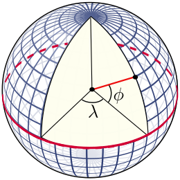 Diagram of the latitude
?
and longitude
λ
angle measurements for a spherical model of the Earth.
Diagram of the latitude
?
and longitude
λ
angle measurements for a spherical model of the Earth.
The "latitude" (abbreviation: Lat.,
?
, or phi) of a point on Earth's surface is the angle between the equatorial plane and the straight line that passes through that point and through (or close to) the center of the Earth.
[note 2]
Lines joining points of the same latitude trace circles on the surface of Earth called
parallels
, as they are parallel to the Equator and to each other. The
North Pole
is 90° N; the
South Pole
is 90° S. The 0° parallel of latitude is designated the
Equator
, the
fundamental plane
of all geographic coordinate systems. The Equator divides the globe into
Northern
and
Southern Hemispheres
.
The "longitude" (abbreviation: Long.,
λ
, or lambda) of a point on Earth's surface is the angle east or west of a reference
meridian
to another meridian that passes through that point. All meridians are halves of great
ellipses
(often called
great circles
), which converge at the North and South Poles. The meridian of the British
Royal Observatory
in
Greenwich
, in southeast London, England, is the international
prime meridian
, although some organizations?such as the French
Institut national de l'information geographique et forestiere
?continue to use other meridians for internal purposes. The prime meridian determines the proper
Eastern
and
Western Hemispheres
, although maps often divide these hemispheres further west in order to keep the
Old World
on a single side. The
antipodal
meridian of Greenwich is both 180°W and 180°E. This is not to be conflated with the
International Date Line
, which diverges from it in several places for political and convenience reasons, including between far eastern Russia and the far western
Aleutian Islands
.
The combination of these two components specifies the position of any location on the surface of Earth, without consideration of
altitude
or depth. The visual grid on a map formed by lines of latitude and longitude is known as a
graticule
.
[7]
The origin/zero point of this system is located in the
Gulf of Guinea
about 625 km (390 mi) south of
Tema
,
Ghana
, a location often facetiously called
Null Island
.
Geodetic datum
[
edit
]
In order to be unambiguous about the direction of "vertical" and the "horizontal" surface above which they are measuring, map-makers choose a
reference ellipsoid
with a given origin and orientation that best fits their need for the area to be mapped. They then choose the most appropriate mapping of the
spherical coordinate system
onto that ellipsoid, called a terrestrial reference system or
geodetic datum
.
Datums may be global, meaning that they represent the whole Earth, or they may be local, meaning that they represent an ellipsoid best-fit to only a portion of the Earth. Points on the Earth's surface move relative to each other due to continental plate motion, subsidence, and diurnal
Earth tidal
movement caused by the
Moon
and the Sun. This daily movement can be as much as a meter. Continental movement can be up to
10 cm
a year, or
10 m
in a century. A
weather system
high-pressure area can cause a sinking of
5 mm
.
Scandinavia
is rising by
1 cm
a year as a result of the melting of the ice sheets of the
last ice age
, but neighboring
Scotland
is rising by only
0.2 cm
. These changes are insignificant if a local datum is used, but are statistically significant if a global datum is used.
[8]
Examples of global datums include
World Geodetic System
(WGS
84, also known as EPSG:4326
[9]
), the default datum used for the
Global Positioning System
,
[note 3]
and the
International Terrestrial Reference System and Frame
(ITRF), used for estimating
continental drift
and
crustal deformation
.
[10]
The distance to Earth's center can be used both for very deep positions and for positions in space.
[8]
Local datums chosen by a national cartographical organization include the
North American Datum
, the European
ED50
, and the British
OSGB36
. Given a location, the datum provides the latitude
 and longitude
 . In the United Kingdom there are three common latitude, longitude, and height systems in use. WGS
84 differs at Greenwich from the one used on published maps OSGB36 by approximately 112
m. The military system
ED50
, used by
NATO
, differs from about 120
m to 180
m.
[8]
. In the United Kingdom there are three common latitude, longitude, and height systems in use. WGS
84 differs at Greenwich from the one used on published maps OSGB36 by approximately 112
m. The military system
ED50
, used by
NATO
, differs from about 120
m to 180
m.
[8]
The latitude and longitude on a map made against a local datum may not be the same as one obtained from a GPS receiver. Converting coordinates from one datum to another requires a
datum transformation
such as a
Helmert transformation
, although in certain situations a simple
translation
may be sufficient.
[11]
In popular GIS software, data projected in latitude/longitude is often represented as a
Geographic Coordinate System
. For example, data in latitude/longitude if the datum is the
North American Datum of 1983
is denoted by 'GCS North American 1983'.
Length of a degree
[
edit
]
On the GRS
80 or
WGS
84
spheroid at
sea level
at the Equator, one latitudinal second measures 30.715
m
, one latitudinal minute is 1843 m and one latitudinal degree is 110.6 km. The circles of longitude, meridians, meet at the geographical poles, with the west?east width of a second naturally decreasing as latitude increases. On the
Equator
at sea level, one longitudinal second measures 30.92 m, a longitudinal minute is 1855 m and a longitudinal degree is 111.3 km. At 30° a longitudinal second is 26.76 m, at Greenwich (51°28′38″N) 19.22 m, and at 60° it is 15.42 m.
On the WGS
84 spheroid, the length in meters of a degree of latitude at latitude
?
(that is, the number of meters you would have to travel along a north?south line to move 1 degree in latitude, when at latitude
?
), is about
 [12]
[12]
The returned measure of meters per degree latitude varies continuously with latitude.
Similarly, the length in meters of a degree of longitude can be calculated as
 [12]
[12]
(Those coefficients can be improved, but as they stand the distance they give is correct within a centimeter.)
The formulae both return units of meters per degree.
An alternative method to estimate the length of a longitudinal degree at latitude
is to assume a spherical Earth (to get the width per minute and second, divide by 60 and 3600, respectively):

where
Earth's average meridional radius
 is
6,367,449 m
. Since the Earth is an
oblate spheroid
, not spherical, that result can be off by several tenths of a percent; a better approximation of a longitudinal degree at latitude
is
is
6,367,449 m
. Since the Earth is an
oblate spheroid
, not spherical, that result can be off by several tenths of a percent; a better approximation of a longitudinal degree at latitude
is

where Earth's equatorial radius
 equals 6,378,137 m and
 ; for the GRS
80 and WGS
84 spheroids,
; for the GRS
80 and WGS
84 spheroids,
 . (
. (
 is known as the
reduced (or parametric) latitude
). Aside from rounding, this is the exact distance along a parallel of latitude; getting the distance along the shortest route will be more work, but those two distances are always within 0.6 m of each other if the two points are one degree of longitude apart.
is known as the
reduced (or parametric) latitude
). Aside from rounding, this is the exact distance along a parallel of latitude; getting the distance along the shortest route will be more work, but those two distances are always within 0.6 m of each other if the two points are one degree of longitude apart.
Longitudinal length equivalents at selected latitudes
| Latitude
|
City
|
Degree
|
Minute
|
Second
|
±0.0001°
|
| 60°
|
Saint Petersburg
|
55.80 km
|
0.930 km
|
15.50 m
|
5.58 m
|
| 51° 28′ 38″ N
|
Greenwich
|
69.47 km
|
1.158 km
|
19.30 m
|
6.95 m
|
| 45°
|
Bordeaux
|
78.85 km
|
1.31 km
|
21.90 m
|
7.89 m
|
| 30°
|
New Orleans
|
96.49 km
|
1.61 km
|
26.80 m
|
9.65 m
|
| 0°
|
Quito
|
111.3 km
|
1.855 km
|
30.92 m
|
11.13 m
|
Alternate encodings
[
edit
]
Like any series of multiple-digit numbers, latitude-longitude pairs can be challenging to communicate and remember. Therefore, alternative schemes have been developed for encoding GCS coordinates into alphanumeric strings or words:
These are not distinct coordinate systems, only alternative methods for expressing latitude and longitude measurements.
See also
[
edit
]
Notes
[
edit
]
- ^
The pair had accurate absolute distances within the Mediterranean but underestimated the
circumference of the Earth
, causing their degree measurements to overstate its length west from Rhodes or Alexandria, respectively.
- ^
Alternative versions of latitude and longitude include geocentric coordinates, which measure with respect to Earth's center; geodetic coordinates, which model Earth as an
ellipsoid
; and geographic coordinates, which measure with respect to a plumb line at the location for which coordinates are given.
- ^
WGS 84 is the default datum used in most GPS equipment, but other datums can be selected.
References
[
edit
]
- ^
Chang, Kang-tsung (2016).
Introduction to Geographic Information Systems
(9th ed.). McGraw-Hill. p. 24.
ISBN
978-1-259-92964-9
.
- ^
DiBiase, David.
"The Nature of Geographic Information"
.
Archived
from the original on 19 February 2024
. Retrieved
18 February
2024
.
- ^
"Using the EPSG geodetic parameter dataset, Guidance Note 7-1"
.
EPSG Geodetic Parameter Dataset
. Geomatic Solutions.
Archived
from the original on 15 December 2021
. Retrieved
15 December
2021
.
- ^
McPhail, Cameron (2011),
Reconstructing Eratosthenes' Map of the World
(PDF)
,
Dunedin
: University of Otago, pp. 20?24,
archived
(PDF)
from the original on 2 April 2015
, retrieved
14 March
2015
.
- ^
Evans, James (1998),
The History and Practice of Ancient Astronomy
, Oxford, England: Oxford University Press, pp. 102?103,
ISBN
9780199874453
,
archived
from the original on 17 March 2023
, retrieved
5 May
2020
.
- ^
"The International Meridian Conference"
.
Millennium Dome: The O2 in Greenwich
. Greenwich 2000 Limited. 9 June 2011. Archived from
the original
on 6 August 2012
. Retrieved
31 October
2012
.
- ^
American Society of Civil Engineers (1 January 1994).
Glossary of the Mapping Sciences
. ASCE Publications. p. 224.
ISBN
9780784475706
.
- ^
a
b
c
A guide to coordinate systems in Great Britain
(PDF)
, D00659 v3.6, Ordnance Survey, 2020,
archived
(PDF)
from the original on 2 April 2020
, retrieved
17 December
2021
- ^
"WGS 84: EPSG Projection -- Spatial Reference"
.
spatialreference.org
.
Archived
from the original on 13 May 2020
. Retrieved
5 May
2020
.
- ^
Bolstad, Paul (2012).
GIS Fundamentals
(PDF)
(5th ed.). Atlas books. p. 102.
ISBN
978-0-9717647-3-6
. Archived from
the original
(PDF)
on 15 October 2020
. Retrieved
27 January
2018
.
- ^
"Making maps compatible with GPS"
. Government of Ireland 1999. Archived from
the original
on 21 July 2011
. Retrieved
15 April
2008
.
- ^
a
b
[1]
Archived
29 June 2016 at the
Wayback Machine
Geographic Information Systems ? Stackexchange
Sources
[
edit
]
External links
[
edit
]
