From Wikipedia, the free encyclopedia
Original file
(1,981 × 803 pixels, file size: 26 KB, MIME type:
image/png
)

|
This
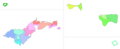
map
image could be re-created
using
vector graphics
as an
SVG
file
. This has several advantages; see
Commons:Media for cleanup
for more information. If an SVG form of this image is available, please upload it and afterwards replace this template with
{{
vector version available
|
new image name
}}
.
It is recommended to name the SVG file “Counties of American Samoa.svg”?then the template
Vector version available
(or
Vva
) does not need the
new image name
parameter.
|
Summary
Licensing
I, the copyright holder of this work, hereby publish it under the following license:


|
This file is made available under the
Creative Commons
CC0 1.0 Universal Public Domain Dedication
.
|
| The person who associated a work with this deed has dedicated the work to the
public domain
by waiving all of their rights to the work worldwide under copyright law, including all related and neighboring rights, to the extent allowed by law. You can copy, modify, distribute and perform the work, even for commercial purposes, all without asking permission.
http://creativecommons.org/publicdomain/zero/1.0/deed.en
CC0
Creative Commons Zero, Public Domain Dedication
false
false
|
Add a one-line explanation of what this file represents
File history
Click on a date/time to view the file as it appeared at that time.
| Date/Time
| Thumbnail
| Dimensions
| User
| Comment
|
|---|
| current
| 05:21, 26 October 2023
|  | 1,981 × 803
(26 KB)
| Heitordp
| Updated boundaries based on 2020 census map
|
| 08:11, 1 June 2020
|  | 1,981 × 803
(26 KB)
| Heitordp
| Uploaded own work with UploadWizard
|
File usage
The following pages on the English Wikipedia use this file (pages on other projects are not listed):
This file contains additional information, probably added from the digital camera or scanner used to create or digitize it.
If the file has been modified from its original state, some details may not fully reflect the modified file.

