Geography of Malaysia
 |
| Continent
| Asia
|
|---|
| Region
| Southeast Asia
|
|---|
| Coordinates
| 2°30'N 112°30'E
|
|---|
| Area
| Ranked 68th
|
|---|
| ? Total
| 330,803 km
2
(127,724 sq mi)
|
|---|
| ? Land
| 99.63%
|
|---|
| ? Water
| 0.37%
|
|---|
| Coastline
| 4,675 km (2,905 mi)
|
|---|
| Borders
| Total land borders
2,669 km (1,658 mi)
Thailand
:
506 km (314 mi)
Indonesia
:
1,782 km (1,107 mi)
Brunei
:
281 km (175 mi)
|
|---|
| Highest point
| Mount Kinabalu
(4,095.2 m)
|
|---|
| Lowest point
| Indian Ocean
(0 m)
|
|---|
| Longest river
| Rajang River
|
|---|
| Largest lake
| Kenyir Lake
(manmade)
Bera Lake
(natural)
|
|---|
| Exclusive economic zone
| 334,671 km
2
(129,217 sq mi)
|
|---|
The
geography of Malaysia
includes both the
physical
and the
human geography
of
Malaysia
, a
Southeast Asian
country made up of two major landmasses separated by water?
Peninsular Malaysia
to the west and
East Malaysia
to the east?and numerous smaller islands that surround those landmasses. Peninsular Malaysia is on the southernmost part of the
Malay Peninsula
, south of
Thailand
, north of
Singapore
and east of the
Indonesian
island of
Sumatra
; East Malaysia comprises most of the northern part of
Borneo
, and shares land borders with
Brunei
to the north and
Indonesian Borneo
to the south.
Climate
[
edit
]
 Koppen?Geiger climate classification
map of Malaysia.
Koppen?Geiger climate classification
map of Malaysia.
Located near the
equator
, Malaysia's climate is categorised as
equatorial
, being hot and humid throughout the year. The average rainfall is 250 centimetres (98 in) a year
[1]
and the average temperature is 25.4 °C (77.7 °F).
[2]
The climates of Peninsular Malaysia and the East Malaysia differ, as the climate on the peninsula is directly affected by wind from the mainland, as opposed to the more maritime weather of East Malaysia. Malaysia is exposed to the
El Nino
effect, which reduces rainfall in the dry season.
Climate change
is likely to have a significant effect on Malaysia, increasing
sea levels
and rainfall, increasing flooding risks and leading to large droughts.
[3]
Malaysia faces two
monsoon
winds seasons, the
southwest monsoon
from late May to September, and the
northeast monsoon
from October to March. The northeast monsoon brings in more rainfall compared to the southwest monsoon,
[4]
originating in
China
and the
North Pacific
. The southwest monsoon originates from the deserts of
Australia
. March and October form transitions between the two monsoons.
[3]
Local climates are affected by the presence of mountain ranges throughout Malaysia, and climate can be divided into that of the highlands, the lowlands, and coastal regions. The coasts have a sunny climate, with temperatures ranging between 23 and 32 °C (73.4 and 89.6 °F), and rainfall ranging from 10 to 30 centimetres (4 to 12 in) a month. The lowlands have a similar temperature, but follow a more distinctive rainfall pattern and show very high humidity levels. The highlands are cooler and wetter, and display a greater temperature variation. A large amount of cloud cover is present over the highlands, which have humidity levels that do not fall below 75%.
[3]
The highest temperature was recorded at
Chuping
,
Perlis
on 9 April 1998 at 40.1 °C (104.2 °F). The lowest temperature in Peninsula Malaysia was recorded at
Cameron Highlands
on 1 February 1978 at 7.8 °C (46.0 °F). The lowest temperature in East Malaysia was recorded on
Mount Kinabalu
at ?4 °C (25 °F). The highest snowfall was recorded in a year was 1 cm (0.4 in) at
Mount Kinabalu
,
Sabah
in 1975, 1993, and 2022. The highest rainfall recorded in a day was 608 mm (23.9 in) in
Kota Bharu
,
Kelantan
on 6 January 1967. The highest rainfall recorded in a year was 5,687 mm (223.9 in) at
Sandakan
,
Sabah
in 2006. Meanwhile, the lowest rainfall recorded in a year was 1,151 mm (45.3 in) at
Tawau
,
Sabah
in 1997.
[5]
The wettest place in Malaysia is
Kuching
,
Sarawak
with an average rainfall of 4,159 mm (163.7 in) with 279 days of rain a year. The driest place in Malaysia is in
Sitiawan
,
Perak
with average rainfall of 1,787 mm (70.4 in) a year.
[5]
| Climate data for Kuala Lumpur (
Sultan Abdul Aziz Shah Airport
, 1991?2020 normals, extremes 1963?2020)
|
| Month
|
Jan
|
Feb
|
Mar
|
Apr
|
May
|
Jun
|
Jul
|
Aug
|
Sep
|
Oct
|
Nov
|
Dec
|
Year
|
| Record high °C (°F)
|
38.0
(100.4)
|
36.7
(98.1)
|
37.9
(100.2)
|
37.2
(99.0)
|
38.5
(101.3)
|
36.6
(97.9)
|
36.3
(97.3)
|
38.0
(100.4)
|
35.9
(96.6)
|
37.0
(98.6)
|
36.0
(96.8)
|
35.5
(95.9)
|
38.5
(101.3)
|
| Mean daily maximum °C (°F)
|
32.6
(90.7)
|
33.3
(91.9)
|
33.7
(92.7)
|
33.7
(92.7)
|
33.6
(92.5)
|
33.3
(91.9)
|
32.8
(91.0)
|
32.8
(91.0)
|
32.7
(90.9)
|
32.6
(90.7)
|
32.3
(90.1)
|
32.0
(89.6)
|
32.9
(91.2)
|
| Daily mean °C (°F)
|
27.3
(81.1)
|
27.8
(82.0)
|
28.1
(82.6)
|
28.1
(82.6)
|
28.5
(83.3)
|
28.4
(83.1)
|
28.0
(82.4)
|
28.0
(82.4)
|
27.7
(81.9)
|
27.5
(81.5)
|
27.1
(80.8)
|
27.1
(80.8)
|
27.8
(82.0)
|
| Mean daily minimum °C (°F)
|
23.8
(74.8)
|
24.0
(75.2)
|
24.5
(76.1)
|
24.7
(76.5)
|
25.0
(77.0)
|
24.8
(76.6)
|
24.4
(75.9)
|
24.5
(76.1)
|
24.2
(75.6)
|
24.2
(75.6)
|
24.1
(75.4)
|
24.0
(75.2)
|
24.4
(75.9)
|
| Record low °C (°F)
|
17.8
(64.0)
|
18.0
(64.4)
|
18.9
(66.0)
|
20.6
(69.1)
|
20.5
(68.9)
|
19.1
(66.4)
|
20.1
(68.2)
|
20.0
(68.0)
|
21.0
(69.8)
|
20.0
(68.0)
|
20.7
(69.3)
|
19.0
(66.2)
|
17.8
(64.0)
|
| Average
precipitation
mm (inches)
|
226.7
(8.93)
|
192.8
(7.59)
|
270.4
(10.65)
|
301.5
(11.87)
|
229.9
(9.05)
|
145.8
(5.74)
|
165.2
(6.50)
|
174.3
(6.86)
|
220.3
(8.67)
|
283.8
(11.17)
|
355.8
(14.01)
|
280.6
(11.05)
|
2,847.1
(112.09)
|
| Average precipitation days
(≥ 1.0 mm)
|
13.6
|
11.9
|
15.0
|
16.8
|
13.2
|
9.6
|
10.6
|
10.9
|
13.3
|
16.3
|
19.7
|
16.3
|
167.2
|
| Average
relative humidity
(%)
|
80
|
80
|
80
|
82
|
81
|
80
|
79
|
79
|
81
|
82
|
84
|
83
|
81
|
| Mean monthly
sunshine hours
|
185.0
|
192.4
|
207.9
|
198.8
|
206.8
|
194.4
|
200.2
|
189.0
|
163.8
|
169.1
|
152.3
|
162.6
|
2,222.3
|
| Source 1:
World Meteorological Organization
[6]
|
| Source 2: Pogodaiklimat.ru
[7]
NOAA (sunshine hours, 1961?1990)
[8]
|
| Climate data for Klang
|
| Month
|
Jan
|
Feb
|
Mar
|
Apr
|
May
|
Jun
|
Jul
|
Aug
|
Sep
|
Oct
|
Nov
|
Dec
|
Year
|
| Mean daily maximum °C (°F)
|
31.0
(87.8)
|
31.7
(89.1)
|
32.3
(90.1)
|
32.0
(89.6)
|
31.9
(89.4)
|
31.8
(89.2)
|
31.4
(88.5)
|
31.3
(88.3)
|
31.2
(88.2)
|
31.1
(88.0)
|
30.8
(87.4)
|
30.7
(87.3)
|
31.4
(88.6)
|
| Daily mean °C (°F)
|
26.3
(79.3)
|
26.7
(80.1)
|
27.2
(81.0)
|
27.3
(81.1)
|
27.4
(81.3)
|
27.3
(81.1)
|
26.8
(80.2)
|
26.7
(80.1)
|
26.8
(80.2)
|
26.7
(80.1)
|
26.5
(79.7)
|
26.3
(79.3)
|
26.8
(80.3)
|
| Mean daily minimum °C (°F)
|
21.6
(70.9)
|
21.7
(71.1)
|
22.1
(71.8)
|
22.7
(72.9)
|
23.0
(73.4)
|
22.8
(73.0)
|
22.3
(72.1)
|
22.2
(72.0)
|
22.4
(72.3)
|
22.4
(72.3)
|
22.3
(72.1)
|
22.0
(71.6)
|
22.3
(72.1)
|
| Average rainfall mm (inches)
|
179
(7.0)
|
139
(5.5)
|
207
(8.1)
|
222
(8.7)
|
173
(6.8)
|
108
(4.3)
|
107
(4.2)
|
150
(5.9)
|
179
(7.0)
|
246
(9.7)
|
265
(10.4)
|
233
(9.2)
|
2,208
(86.8)
|
| Source: Climate-Data.org
[9]
|
| Climate data for Kuching (1991?2020 normals), extremes 1876?present)
|
| Month
|
Jan
|
Feb
|
Mar
|
Apr
|
May
|
Jun
|
Jul
|
Aug
|
Sep
|
Oct
|
Nov
|
Dec
|
Year
|
| Record high °C (°F)
|
34.6
(94.3)
|
34.7
(94.5)
|
35.2
(95.4)
|
36.1
(97.0)
|
36.0
(96.8)
|
35.6
(96.1)
|
36.1
(97.0)
|
36.4
(97.5)
|
36.5
(97.7)
|
35.2
(95.4)
|
34.8
(94.6)
|
34.7
(94.5)
|
36.5
(97.7)
|
| Mean daily maximum °C (°F)
|
30.0
(86.0)
|
30.2
(86.4)
|
31.4
(88.5)
|
32.4
(90.3)
|
32.7
(90.9)
|
32.6
(90.7)
|
32.5
(90.5)
|
32.6
(90.7)
|
32.1
(89.8)
|
32.0
(89.6)
|
31.7
(89.1)
|
31.0
(87.8)
|
31.8
(89.2)
|
| Daily mean °C (°F)
|
25.9
(78.6)
|
26.0
(78.8)
|
26.5
(79.7)
|
26.8
(80.2)
|
27.1
(80.8)
|
27.0
(80.6)
|
27.0
(80.6)
|
26.9
(80.4)
|
26.6
(79.9)
|
26.3
(79.3)
|
26.2
(79.2)
|
26.0
(78.8)
|
26.5
(79.7)
|
| Mean daily minimum °C (°F)
|
23.3
(73.9)
|
23.4
(74.1)
|
23.6
(74.5)
|
23.7
(74.7)
|
23.9
(75.0)
|
23.7
(74.7)
|
23.4
(74.1)
|
23.4
(74.1)
|
23.3
(73.9)
|
23.3
(73.9)
|
23.3
(73.9)
|
23.3
(73.9)
|
23.5
(74.3)
|
| Record low °C (°F)
|
17.8
(64.0)
|
18.9
(66.0)
|
18.3
(64.9)
|
20.0
(68.0)
|
20.6
(69.1)
|
18.9
(66.0)
|
19.4
(66.9)
|
19.4
(66.9)
|
19.3
(66.7)
|
20.5
(68.9)
|
20.0
(68.0)
|
18.9
(66.0)
|
17.8
(64.0)
|
| Average
precipitation
mm (inches)
|
672.3
(26.47)
|
501.4
(19.74)
|
340.2
(13.39)
|
303.2
(11.94)
|
267.8
(10.54)
|
255.4
(10.06)
|
200.9
(7.91)
|
263.7
(10.38)
|
245.3
(9.66)
|
343.1
(13.51)
|
341.5
(13.44)
|
498.1
(19.61)
|
4,232.7
(166.64)
|
| Average precipitation days
(≥ 1.0 mm)
|
21.4
|
17.0
|
17.6
|
17.4
|
15.9
|
14.5
|
13.1
|
14.7
|
15.8
|
19.1
|
21.2
|
22.8
|
210.5
|
| Average
relative humidity
(%)
|
89
|
88
|
86
|
86
|
86
|
84
|
83
|
83
|
85
|
86
|
88
|
89
|
86
|
| Mean monthly
sunshine hours
|
126
|
137
|
149
|
154
|
156
|
159
|
165
|
163
|
158
|
152
|
149
|
136
|
1,804
|
| Source 1:
World Meteorological Organization
[10]
|
| Source 2: Ogimet
[11]
Meteo Climat (record highs and lows),
[12]
Deutscher Wetterdienst
(humidity, 1975?1985)
[13]
|
Climate change
[
edit
]
Geology
[
edit
]
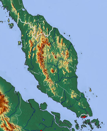 The topography of
Peninsular Malaysia
.
The topography of
Peninsular Malaysia
.
Malaysia is located on the
Sunda Shelf
, and is tectonically inactive. The oldest rocks in the country date from 540 million years ago, and are mostly
sedimentary
. The most common kind of rock is
limestone
that formed during the
Paleozoic
Era. Limestone that had accreted in East Malaysia during the
Tertiary
period later eroded, forming basins of sedimentary rocks that are rich in oil and natural gas. The mountain ranges in Malaysia were formed through
orogenesis
beginning in the
Mesozoic
Era.
[3]
The total land area of Malaysia is 330,803 square kilometres (127,720 sq mi), the 66th
largest country
in the world in terms of area.
[14]
It is the only country to contain land on both mainland
Asia
and the
Malay Archipelago
.
[3]
Peninsular Malaysia makes up 132,090 square kilometres (51,000 sq mi),
[1]
or almost 40% of the country's land area, while East Malaysia covers 198,847 square kilometres (76,780 sq mi), or 60%. From the total land area, 1,200 square kilometres (460 sq mi) or 0.37% is made up of water such as lakes, rivers, or other internal waters. Malaysia has a total coastline of 4,675 kilometres (2,905 mi), and Peninsular Malaysia has 2,068 kilometres (1,285 mi), while East Malaysia has 2,607 kilometres (1,620 mi) of coastline.
[15]
Malaysia has the 29th
longest coastline
in the world. The two distinct parts of Malaysia, separated from each other by the
South China Sea
, share a largely similar landscape in that both
Peninsular Malaysia
and
East Malaysia
feature coastal plains rising to hills and mountains.
[15]
 The topography of Malaysian Borneo.
Peninsular Malaysia
covers the southern half of the
Malay Peninsula
,
[3]
and extends 740 kilometres (460 mi) from north to south, and its maximum width is 322 kilometres (200 mi).
[1]
It is mountainous, with more than half of it over 150 metres (492 ft) above
sea level
.
[3]
About half of Peninsular Malaysia is covered by
granite
and other
igneous rocks
, a third more is covered by stratified rocks older than the granite, and the remainder is covered by
alluvium
.
[16]
Harbours are only available on the peninsula's western side,
[1]
and the most fertile land occurs when river valleys flow out to the sea. The coastal plains bordering the
Strait of Malacca
are the most densely populated areas of Malaysia, and contains Malaysia's capital,
Kuala Lumpur
.
[3]
East Malaysia, on the island of
Borneo
, has a coastline of 2,607 kilometres (1,620 mi).
[15]
It is divided between coastal regions, hills and valleys, and a mountainous interior. There are only two major cities,
Kuching
and
Kota Kinabalu
. Much of southern Sarawak is coastal lowlands, which shifts to a series of plateaus going north, ending in the mountainous regions of Sabah.
[3]
Mountain ranges
[
edit
]
 Mount Kinabalu
, the highest point of Malaysia, is located in
Sabah
.
Mount Kinabalu
, the highest point of Malaysia, is located in
Sabah
.
The highest mountain range in Malaysia is the
Crocker Range
in Sabah, which divides the state in half. This range includes
Mount Kinabalu
, the highest mountain in the country,
[17]
as well as
Mount Tambuyukon
, the third highest in the country. Mount Kinabalu, is 4,095.2 metres (13,436 ft), and is protected as it is within
Kinabalu Park
, a UNESCO
World Heritage Site
and national park.
[18]
Mount Kinabalu is 55% (by 1,453.2 metres (4,768 ft) margin) taller than
Mount Trusmadi
, Malaysia's second tallest mountain.
[
citation needed
]
Mountain ranges in East Malaysia tend to follow north?south or northeast?southwest paths, and the highest ranges form the border between Malaysia and Indonesia. The mountains contain many jagged limestone peaks.
[3]
The
Trus Madi Range
, also in Sabah, houses Mount Trus Madi.
Bombalai Hill
in Sabah is the only active
volcano
in Malaysia.
[
citation needed
]
Peninsular Malaysia contains numerous mountain ranges running parallel from north to south along the peninsula.
[3]
The main mountain range is the
Titiwangsa Mountains
, which divides the peninsula between its east and west coasts.
[19]
It houses
Mount Korbu
, the second highest peak in Peninsular Malaysia. These mountains are heavily forested, and mainly composed of
granite
. The range is the origin of some of Peninsular Malaysia's river systems.
[20]
To the east of this range is the
Bintang Range
.
[1]
The highest peak in Peninsular Malaysia is
Mount Tahan
, located on the
Tahan Range
.
[
citation needed
]
Caves
[
edit
]
Numerous caves run through the country due to the
karst
landscape caused by water eroding limestone. The
Mulu Caves
in East Malaysia are the largest caves in the world. They are located between the
Penambo range
and
Brunei
, and are a major tourist attraction. At 700 metres (2,297 ft) long and 70 metres (230 ft) high the
Sarawak Chamber
is the largest cave chamber in the world. Other famous caves are the 1.6 kilometres (1 mi)
Deer Cave
and Lang's Cave.
[3]
Islands
[
edit
]
 A beach on
Redang Island
in the South China Sea.
A beach on
Redang Island
in the South China Sea.
Malaysia contains
numerous islands
, the largest of which fully within Malaysia is
Banggi Island
in
Sabah
, which has an area of 440.7 square kilometres (170 sq mi).
[21]
It is followed by
Bruit Island
in Sarawak,
Langkawi
in Kedah, and
Penang Island
in Penang. The largest island shared with another country is
Borneo
, followed by
Sebatik Island
. In addition, Malaysia lies within the world's
coral reef
distribution.
[22]
The reefs can be usually found around islands such as
Sipadan
Island,
Swallow Reef
, and
Redang Island
.
[23]
Sipadan, an
underwater mountain
, is Malaysia's only oceanic island.
[24]
Coasts
[
edit
]
A recent global remote sensing analysis suggests that there were 1,713 km
2
of tidal flats in Malaysia, making it the 19th ranked country in terms of how much tidal flat occurs there.
[25]
Forests
[
edit
]
 Bantang River Recreational Forest in
Segamat District
,
Johor
.
Bantang River Recreational Forest in
Segamat District
,
Johor
.
Malaysian forests can be categorised as
tropical rainforests
. Approximately 58.2% of Malaysia's land is covered by forest. A large amount of lowland forest is present below an altitude of 760 metres (2,493 ft).
[1]
East Malaysia, like most of Borneo, was formerly covered by the
Borneo lowland rain forests
[26]
with over 2000 tree species.
[3]
However, much of it has been cleared,
[26]
due to the increase in logging since the 1960s and the increase of shifting cultivation. Over 80% of Sarawak's forests have been felled, and the logging throughout East Malaysia has polluted waterways, increased erosion, and damaged agriculture.
[3]
Some state governments have now taken measures to halt the degradation of the rainforest.
[26]
Malaysia's rainforests are made of a variety of types, mainly
dipterocarp
,
swamps
, and
mangroves
. The majority of the forest is
dipterocarp
forests.
[26]
Dipterocarps species are centred in Malaysia.
[27]
There are over 1,425 square kilometres (550 sq mi) of mangroves in Malaysia.
[1]
Some areas are designated as forest reserves, state parks, or national parks. The management of these reserves is done by the Department of Wildlife and National Park, the Forest Department of Sarawak, the Sabah Forestry Department, the Sabah Foundation, and
Sabah Parks
. As of 2000, there are two
World Heritage Sites
under the natural category –
Kinabalu Park
and
Gunung Mulu National Park
.
[
citation needed
]
Ecoregions
[
edit
]
Malaysia is divided into several tropical forest ecoregions.
Peninsular Malaysia is home to the
Peninsular Malaysian rain forests
,
Peninsular Malaysian montane rain forests
,
Peninsular Malaysian peat swamp forests
, and
Tenasserim-South Thailand semi-evergreen rain forests
.
Eastern Malaysia is home to the
Borneo lowland rain forests
,
Borneo montane rain forests
,
Borneo peat swamp forests
,
Southwest Borneo freshwater swamp forests
, and
Sundaland heath forests
.
[28]
Peninsular Malaysia's west coast is home to the
Myanmar Coast mangroves
. The
Indochina mangroves
fringe Peninsular Malaysia's east coast. The
Sunda Shelf mangroves
line Borneo's coast.
Extreme points
[
edit
]
The southernmost point of Malaysia is located in the district of
Serian
in Sarawak.
Tanjung Piai
on the southern tip of
Johor
is the southernmost point of the
Malay Peninsula
, and thus of the whole of continental
Eurasia
.
[29]
[30]
The easternmost point is found on the tip of
Dent Peninsula
in
Lahad Datu
district in Sabah. The northernmost point is found on the northern tip of Banggi Island. The westernmost point is
Perak Island
, a sandstone rock which is part of
Kedah
state that rises at the center of the Strait of Malacca.
[
citation needed
]
Bodies of water
[
edit
]
 The 1056m
[1]
Johor-Singapore Causeway
connects Malaysia and Singapore across the
Straits of Johor
. In the background is
Johor Bahru
.
The 1056m
[1]
Johor-Singapore Causeway
connects Malaysia and Singapore across the
Straits of Johor
. In the background is
Johor Bahru
.
Between Peninsular Malaysia and East Malaysia is the
South China Sea
, the largest body of water around Malaysia. Facing the western coast of Peninsular Malaysia is the
Strait of Malacca
towards the south, and the
Andaman Sea
towards the north. The
Strait of Malacca
, lying between
Sumatra
and Peninsular Malaysia, is arguably the most important shipping lane in the world.
[31]
These seas are
marginal seas
of the
Indian Ocean
.
[
citation needed
]
Off the east coast of Peninsular Malaysia is the South China Sea,
[3]
while a small part in the north lies within the
Gulf of Thailand
. These form part of the marginal seas of the
Pacific Ocean
. The
Straits of Johor
off the south of Peninsular Malaysia acts as the maritime
border of Malaysia and Singapore
.
[
citation needed
]
In East Malaysia, the western coasts of Sabah and Sarawak face the South China Sea. The northeast coast of Sabah faces the
Sulu Sea
, while the southeast coast of Sabah faces the
Celebes Sea
.
[3]
Malaysia claims 12
nm
(22 kilometres (14 mi)) as its
territorial waters
,
[32]
which extend into the
Coral Triangle
.
[33]
It also has an
exclusive economic zone
of 334,671 km
2
(129,217 sq mi) based on 200 metres (656 ft)
nautical miles
from its coastal baseline. Malaysia claims 200 metres (656 ft) in the depth of the
continental shelf
or to the depth of exploration within the area below the South China Sea known as
Sundaland
.
[34]
[
failed verification
]
The territorial claim for the Strait of Malacca is shared between Malaysia and Indonesia in accordance to a treaty signed in 1970 known as the
Treaty Between the Republic of Indonesia and Malaysia on Determination of boundary Lines of Territorial Waters of the two Nations at the Strait of Malacca
.
[35]
Lakes
[
edit
]
 Ayer Keroh Lake
.
Ayer Keroh Lake
.
The
Bera Lake
in Pahang is one of the largest lakes in Malaysia, and one of the only two natural lakes in Malaysia with
Chini Lake
.
Pedu Lake
is a 12 kilometres (7 mi) long lake located 5 kilometres (3 mi) from the
Malaysia?Thailand border
.
Kenyir Lake
is the largest artificial lake in Southeast Asia.
[
citation needed
]
Rivers
[
edit
]
There are many systems of rivers found around Malaysia. The longest is the
Rajang River
in Sarawak with a length of 760 kilometres (472 mi). The second longest is the
Kinabatangan River
in Sabah with a length of 560 kilometres (348 mi). The longest river in Peninsular Malaysia is the
Pahang River
with a length of 435 kilometres (270 mi).
[
citation needed
]
Wildlife
[
edit
]
Malaysia is a
megadiverse country
, with a high number of species and high levels of endemism.
[36]
These forests contain the
Rafflesia
, the world's largest flower.
[26]
The clearing of the
Borneo lowland rain forests
has caused wildlife to retreat into the
upland rain forests
inland.
[26]
Natural disasters
[
edit
]
Malaysia's geographical location protects the country from most major natural disasters. It is located on a seismically stable plate that minimises direct risks of
earthquakes
and
volcanoes
, is partially protected from
tsunamis
by surrounding landmasses, and is a rare target for
tropical cyclones
. However, the country's tropical climate opens the country to the risk of
flooding
,
landslides
and prolonged
droughts
.
[
citation needed
]
Global climate change may exacerbate the situation with extreme weather events in Southeast Asia raising the economic, political and social risks for Malaysia.
[37]
Storms and flooding
[
edit
]
 Peninsular Malaysia Precipitation Map in December 2004 showing heavy precipitation on the east coast, causing floods there.
With 189 water basins and an average rainfall of over 2,000?4,000 mm per year, Malaysia is prone to
riverine
,
muddy
floods
that range from hours-long
flash floods
, to prolonged flooding on flat, low-lying land along major tributaries and main stems. 15 instances of major flooding in the region have occurred since 1926; notable floods include the
1971 floods
in and around
Kuala Lumpur
that killed 32, affected 180,000 and prompted the launch of flood control projects in the city,
2006 and 2007 floods
in
Johor
that resulted in 18 deaths and
RM
1.5 billion in damages in addition to the temporary displacement of 110,000 people,
[38]
and major flooding centered around the
Klang Valley
in
2021?2022
that led to 54 deaths, at least RM5.3?6.5 billion in damages and left 125,490 displaced. Flooding has been a major concern in recent decades due to rapid development in river catchment areas that has led to increased surface and river runoffs, increased sediment buildup in rivers, and frequent erosion along river banks.
[
citation needed
]
Due to weak
Coriolis forces
from its close proximity to the equator, direct passages of
tropical cyclones
are rare for the country despite its proximity to the highly active Northwestern Pacific
tropical cyclone basin
. The only tropical cyclones to significantly affect Malaysia since records began were
Tropical Storm Greg
in 1996 and
Tropical Storm Vamei
in 2001; the former's passage over
Sabah
remains the deadliest tropical storm in the country's history, with 238 dead and 102 missing. However, tropical depressions as well as outlying storm patterns generated by passing cyclones have made landfall regularly, often leading to abnormally high rainfall and flooding, such as the tail of
Typhoon Lekima
striking the
Malay Peninsula
in August 2018, and the path of 2021's
Tropical Depression 29W
across central Peninsular Malaysia contributing to
record precipitation and protracted flooding in the region
between December 2021 and January 2022.
[
citation needed
]
Seismic activity
[
edit
]
Malaysia is largely seismically stable with little modern history of volcanic activity, being situated entirely on the
Sunda
tectonic plate
, between two major boundaries of the
Australian Plate
and
Eurasian Plate
in the west of Peninsular Malaysia, and the
Philippine Sea Plate
and
Eurasian Plate
at East Malaysia.
[
citation needed
]
Peninsular Malaysia is more accustomed to only light tremors caused by earthquakes along the
Sumatran
islands of
Indonesia
generated predominantly by the
Great Sumatran fault
and
Sunda megathrust
.
[39]
However, a pair of rare earthquakes that did not originate in Sumatra were felt in much of Malaya and Singapore on 31 January 1922 and 7 February 1922.
[40]
As is with Singapore, the effects of tremors are also felt more significantly on skyscrapers common in populated centres in Malaysia due to the effects of
mechanical resonance
. East Malaysian states, particularly
Sabah
, are at risk of more moderate
interplate
and
intraplate earthquakes
due to its closer proximity to active tectonic activities along the
Ring of Fire
, with record earthquakes in the country occurring in Sabah in 1923, 1951,
1976
and
2015
at an average of 6.0?6.5
M
w
.
[41]
The fringes of Sabah also lay host to a series of the country's only volcanoes
at the Tawau volcanic field and off the state's coast
. Prominently,
Mount Bombalai
last erupted during the
Holocene
epoch, while the last major eruption in present-day Malaysia occurred during the formation of a chain of
volcanic islands
(prominently including
Pulau Tiga
) off
Kimanis Bay
in 1897.
[
citation needed
]
Interest towards
tsunami
risks to Malaysia has also heighten since the
2004 Indian Ocean earthquake
. Although the western coast of Peninsular Malaysia was largely shielded by Sumatra from the full effects of waves generated by the earthquake, weaker deflected tsunami waves
led to damage and casualties
along the northwestern coast of Peninsular Malaysia, affecting coastal
Perlis
,
Kedah
,
Penang
and
Perak
. The disaster also highlights the risk of further tsunamis that may strike coasts in direct line of undersea faults, primarily around the
South China Sea
.
[42]
Natural resources
[
edit
]
Minerals and petroleum
[
edit
]
Malaysia produces petroleum and is a net exporter.
[43]
Malaysia also produces
liquefied natural gas
as well as various other related products, most of which are found off the coasts of
Terengganu
,
Sabah
, and
Sarawak
. Other notable natural resources includes tin, timber, copper, iron, ore, and bauxite.
[
citation needed
]
Malaysia was the largest exporter of
tin
until the industry-wide collapse in the 1980s. Tin deposits are found in areas in
Selangor
,
Kinta
valley in
Perak
,
Pahang
and
Johor
.
[44]
There are significant deposit of gold in the
Pahang
towns of
Raub
and
Kuala Lipis
and also
Kelantan
's district of
Gua Musang
.
[45]
Coal
is mostly concentrated in the
Sarawak
towns of
Kapit
,
Mukah
and
Silantek
.
[
citation needed
]
Forestry
[
edit
]
Timber
can be found in the vast jungles in Malaysia, especially in East Malaysia. Malaysia's total exports of timber and other timber products amounted to
MYR
23.4 billion in 2007.
[46]
Land use
[
edit
]
Large areas of land are used as
palm oil
plantations,
rubber
plantations, and
paddy fields
. Malaysia is the world's largest exporter of palm oil producing 15.8 million tonnes of crude palm oil in 2007.
[43]
[46]
Malaysia is also one of the largest producers and exporters of rubber and other rubber products.
[47]
As of 2011, the percentage arable land in Malaysia is 5.44%. Croplands consists of 17.49% while other land uses consists of 77.07%.
[48]
As of 2009, irrigated land covers 3,800 km
2
. Total renewable water resource total 580 cubic km as of 2011.
[
citation needed
]
Human geography
[
edit
]
Peninsular Malaysia is more populated than East Malaysia with 79.2% of the population living in Peninsular Malaysia. In 2002, 59% of Malaysian population lived in
urban areas
, while the rest live in
rural
areas.
[49]
The largest city is
Kuala Lumpur
with a population of 1.89 million people in the city, and about 7 million in the metropolitan area known as
Klang Valley
. Other major cities include
George Town
,
Ipoh
,
Johor Bahru
,
Kuching
, and
Kota Kinabalu
.
|
|
Rank
|
Name
|
State
|
Municipal pop.
|
Rank
|
Name
|
State
|
Municipal pop.
|
|

Kuala Lumpur

Kajang
|
1
|
Kuala Lumpur
|
Federal Territory
|
1,982,112
|
11
|
Ipoh
|
Perak
|
759,952
|
Seberang Perai

Subang Jaya
|
| 2
|
Kajang
|
Selangor
|
1,047,356
|
12
|
Seremban
|
Negeri Sembilan
|
681,541
|
| 3
|
Seberang Perai
|
Penang
|
946,092
|
13
|
Iskandar Puteri
|
Johor
|
575,977
|
| 4
|
Subang Jaya
|
Selangor
|
902,086
|
14
|
Kuantan
|
Pahang
|
548,014
|
| 5
|
Klang
|
Selangor
|
902,025
|
15
|
Sungai Petani
|
Kedah
|
545,053
|
| 6
|
Johor Bahru
|
Johor
|
858,118
|
16
|
Ampang Jaya
|
Selangor
|
531,904
|
| 7
|
Shah Alam
|
Selangor
|
812,327
|
17
|
Kota Kinabalu
|
Sabah
|
500,425
|
| 8
|
George Town
|
Penang
|
794,313
|
18
|
Malacca City
|
Malacca
|
453,904
|
| 9
|
Petaling Jaya
|
Selangor
|
771,687
|
19
|
Sandakan
|
Sabah
|
439,050
|
| 10
|
Selayang
|
Selangor
|
764,327
|
20
|
Alor Setar
|
Kedah
|
423,868
|
Political geography
[
edit
]
 A Map of
Malaysia's states
.
A Map of
Malaysia's states
.
Malaysia is divided into
thirteen states
and three
Federal Territories
. Eleven states and two Federal Territories are found in Peninsular Malaysia, while two states and one Federal Territory are found in East Malaysia. The states are further divided into
administrative districts
. In Sabah and Sarawak, they are first divided into
divisions
, then further divided into districts. There are separate subdivisions for
electoral districts
for polling purposes.
[
citation needed
]
International
borders
between Malaysia and
Indonesia
,
Thailand
,
Singapore
and
Brunei
are defined mostly by geological features such as the
Perlis River
and Golok River between Malaysia and Thailand;
Straits of Johor
between Malaysia and Singapore; and Pagalayan Canal between Malaysia and Brunei. However, borders that extends to the seas are defined by agreements such as
Straits Settlement and Johore Territorial Waters Agreement of 1927
which defines Malaysia and Singapore water borders.
[
citation needed
]
Border disputes
[
edit
]
Malaysia's
land borders
are well established. The border with Thailand was established in 1909 when Siam ceded
Kedah
,
Kelantan
,
Perlis
and
Terengganu
to the British. Maritime border disputes between
Brunei
and Malaysia and a Bruneian claim on
Limbang
, Sarawak were resolved in an exchange of letters between the two countries on 16 March 2009 after 20 years of negotiations.
[50]
Malaysia and
Indonesia
have some overlapping maritime claims, notably in the area around
Sabah
. An ongoing series of meetings to resolve these claims has produced 16 border agreements (to September 2010).
[51]
[52]
Malaysia and
Singapore
also have disputes concerning some maritime borders.
[15]
The
Philippines
has a dormant claim to the eastern part of the Malaysian state of
Sabah
.
[15]
Malaysia is also involved in a dispute involving
Vietnam
, Brunei, the
People's Republic of China
, the Philippines, and the
Republic of China
(Taiwan), concerning the
Spratly Islands
in the
South China Sea
.
[15]
See also
[
edit
]
References
[
edit
]
- ^
a
b
c
d
e
f
g
h
Saw Swee Hock (2007).
The Population of Peninsular Malaysia
. Institute of Southeast Asian Studies.
ISBN
978-981-230-427-8
.
- ^
"Malays Travel Guide:Climate of Malaysia"
. Circle of Asia
. Retrieved
28 July
2008
.
- ^
a
b
c
d
e
f
g
h
i
j
k
l
m
n
o
p
World and Its Peoples: Eastern and Southern Asia
. Marshall Cavendish. 2007.
ISBN
978-0-7614-7642-9
.
- ^
"Weather phenomena"
. Malaysian Meteorological Department. Archived from
the original
on 20 March 2008
. Retrieved
31 July
2008
.
- ^
a
b
"General Climate Information"
. Archived from
the original
on 16 November 2015
. Retrieved
3 December
2016
.
- ^
"World Meteorological Organization Climate Normals for 1991?2020"
.
World Meteorological Organization Climatological Standard Normals (1991?2020)
. National Oceanic and Atmospheric Administration. Archived from
the original
on 19 October 2023
. Retrieved
19 October
2023
.
- ^
"Climate of Kuala lumpur"
(in Russian). Weather and Climate (Погода и климат). Archived from
the original
on 23 March 2018
. Retrieved
8 October
2013
.
- ^
"Kuala Lumpur Climate Normals 1961?1990"
.
National Oceanic and Atmospheric Administration
. Retrieved
24 April
2015
.
- ^
"Climate: Klang"
. Climate-Data.org
. Retrieved
1 August
2020
.
- ^
"World Meteorological Organization Climate Normals for 1991?2020"
. World Meteorological Organization
. Retrieved
19 October
2023
.
- ^
"CLIMAT summary for 96413: Kuching (Malaysia) ? Section 2: Monthly Normals"
.
CLIMAT monthly weather summaries
. Ogimet
. Retrieved
21 January
2021
.
- ^
"Station Kuching"
(in French). Meteo Climat
. Retrieved
14 October
2016
.
- ^
"Klimatafel von Kuching / Insel Borneo (Kalimantan) / Malaysia"
(PDF)
.
Baseline climate means (1961?1990) from stations all over the world
(in German). Deutscher Wetterdienst
. Retrieved
17 October
2016
.
- ^
"Laporan Kiraan Permulaan 2010"
. Jabatan Perangkaan Malaysia. p. 27. Archived from
the original
on 27 December 2010
. Retrieved
2 August
2023
.
- ^
a
b
c
d
e
f
CIA.
The World Fact Book
: Malaysia
. Retrieved 4 April 2019.
- ^
Encyclopædia Britannica.
The Land (West Malaysia).
- ^
Simon Richmond (2010).
Malaysia, Singapore & Brunei
. Lonely Planet.
ISBN
978-1-74104-887-2
.
- ^
"Mount Kinabalu ? revered abode of the dead"
. Ecologyasia.com
. Retrieved
17 September
2010
.
- ^
Alan M. Stevens (2004).
A comprehensive Indonesian-English Dictionary
. PT Mizan Publika.
ISBN
978-979-433-387-7
.
- ^
"Main Range (mountains, Malaysia)"
.
Encyclopædia Britannica
. Retrieved
1 October
2010
.
- ^
Mohd Huzaifah Muntalip (16 May 2011).
"Top 5 Largest Islands in Malaysia"
.
Akademi Fantasia Travel
. Archived from
the original
on 25 February 2021
. Retrieved
2 September
2016
.
- ^
"Coral reef image"
. NASA. Archived from
the original
on 5 August 2008
. Retrieved
31 July
2008
.
- ^
Praveena, S. M., Siraj, S. S., & Aris, A. Z. (2012). Coral reef studies and threats in Malaysia: A mini review.
Reviews in Environmental Science and Bio/Technology, 11
(1), 27-39.
https://doi.org/10.1007/s11157-011-9261-8
- ^
"Go: A diver's paradise"
.
New Straits Times
. 1 December 2010. Archived from
the original
on 22 June 2011
. Retrieved
15 December
2010
.
- ^
Murray, N.J.; Phinn, S.R.; DeWitt, M.; Ferrari, R.; Johnston, R.; Lyons, M.B.; Clinton, N.; Thau, D.; Fuller, R.A. (2019).
"The global distribution and trajectory of tidal flats"
.
Nature
.
565
(7738): 222?225.
doi
:
10.1038/s41586-018-0805-8
.
PMID
30568300
.
S2CID
56481043
.
- ^
a
b
c
d
e
f
"The Malaysian Rainforest"
. Wwf.org.my
. Retrieved
1 October
2010
.
- ^
Terrestrial ecoregions of the Indo-Pacific: a conservation assessment
by Eric D. Wikramanayake, pg 93
- ^
Wikramanayake, Eric; Eric Dinerstein; Colby J. Loucks; et al. (2002).
Terrestrial Ecoregions of the Indo-Pacific: a Conservation Assessment.
Washington, DC: Island Press.
- ^
"Asia's southernmost tip"
.
Travel Times
. 3 July 2007. Archived from
the original
on 3 July 2007
. Retrieved
26 October
2010
.
- ^
Sager Ahmad (22 August 2003).
"Tanjung Piai, The End of Asia"
.
Travel Times
. Archived from
the original
on 22 August 2003
. Retrieved
26 October
2010
.
- ^
Andrew Marshall (31 July 2006).
"Waterway To the World - Summer Journey"
.
Time
. Archived from
the original
on 1 September 2006
. Retrieved
28 October
2010
.
- ^
"Malaysia Maritime claims - Geography"
.
www.indexmundi.com
. Retrieved
29 January
2018
.
- ^
"WWF ? Coral Triangle"
. Wwf.panda.org
. Retrieved
14 September
2010
.
- ^
"Maritime Claims"
. CIA The World Factbook. Archived from
the original
on 19 November 2012
. Retrieved
31 July
2008
.
- ^
"Indonesia-Malaysia Territorial Sea Boundary"
(PDF)
. The Geographer, Department of State, USA
. Retrieved
31 July
2008
.
- ^
"Biodiversity Theme Report"
. Australian Government Department of the Environment, Water, Heritage and the Arts. 2001. Archived from
the original
on 14 May 2007
. Retrieved
24 January
2009
.
- ^
Overland, Indra et al. (2017)
Impact of Climate Change on ASEAN International Affairs: Risk and Opportunity Multiplier
, Norwegian Institute of International Affairs (NUPI) and Myanmar Institute of International and Strategic Studies (MISIS).
- ^
"Flood and Drought Management in Malaysia"
. Ministry of Natural Resources and Environment Malaysia. 21 June 2007. Archived from
the original
on 10 September 2008
. Retrieved
1 August
2008
.
- ^
"Keseismikan Malaysia"
(in Malay). Meteorological Department of Malaysia. Archived from
the original
on 24 June 2008
. Retrieved
30 July
2008
.
- ^
Martin, Stacey Servito; Wang, Yu; Muzli, Muzli; Wei, Shengji (27 May 2020).
"The 1922 Peninsula Malaysia Earthquakes: Rare Intraplate Seismicity within the Sundaland Block in Southeast Asia"
.
Seismological Research Letters
.
91
(5): 2531?2545.
doi
:
10.1785/0220200052
.
ISSN
0895-0695
.
S2CID
219744642
.
- ^
"Recent Earthquake Near Sabah, Malaysia"
.
earthquaketrack.com
. Retrieved
16 July
2015
.
- ^
Dr Salleh Buang (26 April 2006).
"Dealing with a restless planet"
.
New Straits Times
. Archived from
the original
on 22 August 2006
. Retrieved
31 July
2008
.
- ^
a
b
"Malaysia export growth slows to 16.9%"
.
International Herald Tribune
. 4 January 2005
. Retrieved
30 July
2008
.
- ^
"Tin Mine Operators in Malaysia"
. Geoscience and Minerals Department of Malaysia. Archived from
the original
on 10 November 2008
. Retrieved
4 August
2008
.
- ^
"Gold Mine Operator in Malaysia". Minerals and Geoscience Department of Malaysia.
- ^
a
b
"Key Statistics of Malaysia"
. Department of Statistics Malaysia. Archived from
the original
on 23 March 2008
. Retrieved
30 July
2008
.
- ^
"Malaysia Chemical Reports 2008"
. Business Monitor International. Archived from
the original
on 29 April 2008
. Retrieved
31 July
2008
.
- ^
"Environment at a Glance 2004: Malaysia"
(PDF)
. World Bank
. Retrieved
31 July
2008
.
- ^
"FACT Sheet Malaysia: Rural Women in the Malaysian Economy"
. Food and Agriculture Organization for the United Nations
. Retrieved
30 July
2008
.
- ^
"Border Issues Between Malaysia, Brunei Solved: Official"
. CRIENGLISH.com. Xinhua News Agency. Archived from
the original
on 15 January 2013
. Retrieved
6 September
2010
.
- ^
"Indonesia, Malaysia to discuss border issues in September"
. Xinhua News Agency. Archived from
the original
on 6 November 2012
. Retrieved
6 September
2010
.
- ^
"Malaysia, Indonesia ministers meet to soothe tensions"
. Channel NewsAsia. Archived from
the original
on 21 October 2012
. Retrieved
6 September
2010
.
External links
[
edit
]
