Mountainous region of Vietnam
Place in Vietnam
Central Highlands
Cao nguyen Trung ph?n
|
|---|
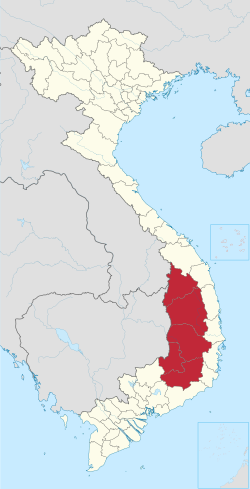 Location of the Central Highlands region in Vietnam
|
| Country
|  Vietnam
|
|---|
|
| ? Total
| 54,548.31 km
2
(21,061.22 sq mi)
|
|---|
|
| ? Total
| 6,092,420
|
|---|
| ? Density
| 110/km
2
(290/sq mi)
|
|---|
|
| ? Total
| VND
273 trillion
US$
11.970 billion (2021)
|
|---|
| Time zone
| UTC+7
(UTC +7)
|
|---|
The
Central Highlands
(
Vietnamese
:
Cao nguyen Trung ph?n
),
South Central Highlands
(
Vietnamese
:
Cao nguyen Nam Trung B?
),
Western Highlands
(
Vietnamese
:
Tay Nguyen
) or
Midland Highlands
(
Vietnamese
:
Cao nguyen Trung b?
) is a
region
located in the south central part of
Vietnam
. It contains the provinces of
đ?k L?k
,
đ?k Nong
,
Gia Lai
,
Kon Tum
, and
Lam đ?ng
.
Geography
[
edit
]
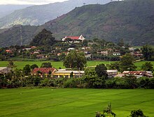 Dong Son village in
đ?k L?k Province
, surrounded by mountains.
Dong Son village in
đ?k L?k Province
, surrounded by mountains.
Central Highlands is a plateau bordering the lower part of
Laos
and northeastern
Cambodia
.
Kon Tum Province
shares a border with both Laos and Cambodia but
Gia Lai Province
and
đ?k L?k Province
only share borders with Cambodia.
Lam đ?ng Province
is landlocked, like four other provinces in the region, but has no international border.
Actually, Central Highlands is not situated on a unique plateau, instead, it lies on a series of contiguous plateaus, namely Kon Tum Plateau at the height of 500 m, Kon Plong Plateau, Kon Ha N?ng Plateau, Pleiku Plateau with the height of around 800m, Mdrak Plateau of approximately 500 m, đ?k L?k Plateau of around 800m, M? Nong Plateau with the height of about 800?1000 m,
Lam Vien Plateau
of approximately 1500 m and Di Linh Plateau of about 900?1000 m. All of these plateaux are surrounded by high mountain ranges and mounts (South
Annamite Range
).
The Central Highlands are mostly drained by tributaries of the
Mekong
. The Sesan or
Tonle San
river drains the northern portion of the highlands, and the
Srepok River
the southern. A series of shorter rivers run from the eastern edge of the highlands to the Vietnamese coast.
Tay Nguyen can be divided into three subregions according to their deviation in topography and climate, namely: North Tay Nguyen (B?c Tay Nguyen) (inclusive of Kon Tum and Gia Lai provinces), Middle Tay Nguyen (Trung Tay Nguyen) (covering provinces of đ?k L?k and đ?k Nong), South Tay Nguyen (Nam Tay Nguyen) (Lam đ?ng). Trung Tay Nguyen has a lower altitude and therefore has a higher temperature than the other two subregions.
Provinces
[
edit
]
Statistics of the Central Highlands
Province-
Level
Division
|
Capital
|
Population
(2022)
[1]
|
Area
(km
2
)
[1]
[2]
|
| đ?k L?k
|
Buon Ma Thu?t
|
1,918,440
|
13,070.41
|
| đ?k Nong
|
Gia Ngh?a
|
670,560
|
6,509.27
|
| Gia Lai
|
Pleiku
|
1,590,980
|
15,510.13
|
| Kon Tum
|
Kon Tum
|
579,910
|
9,677.30
|
| Lam đ?ng
|
Da Lat
|
1,332,530
|
9,781.20
|
History
[
edit
]
The native inhabitants of the Central Highlands (
Montagnards
, Mountain peoples) are various peoples that mainly belonged to the two major
Austronesian
(Highland
Chamic
) and
Austroasiatic
(
Bahnaric
) ethnolinguistic families. According to Peng et al. (2010) & Liu et al. (2020), Austronesian Chamic groups were well known of being seafarers with the original homeland of
Taiwan
, might have migrated to present-day Central Vietnam by sea from Maritime Southeast Asia around ~ 2,500 kya, while were making contact/or possibly absorbed the previously earlier Austroasiatic inhabitants (research shows shared high frequencies of AA-associated ancestry among Vietnam's Austronesian Chamic highlanders than Austronesian Chamic lowlanders which are more related with Taiwanese AN groups).
[3]
[4]
Throughout pre-modern history, the Central Highlands were not under the control of surrounding lowland classical kingdoms, thus much of prehistoric indigenous cultures were preserved. Highlands and mountains acted like barricades that curtailed much of the lowland influences on the Central Highlands people. The region falls into the geographical category described by
James C. Scott
as
terra
zomia
, a huge mountainous landmass of Mainland Southeast Asia (including Southern China and Northeast India).
[5]
During the early fifteenth century, the northern part of Central Highlands (around present-day
An Khe
) had a dubious ruler named
?r? Gajar?ja
(King of the Elephants) with the title "The great king of the Montagnards of
Madhyamagr?ma
" ("big village"), who was a vassal of
Cham
king
Indravarman VI
(r. 1400?1441) in the lowland.
[6]
Despite geographic barriers, the Cham extensively used the Highlands as their resources backyard to provide medieval commodities. They also built several temples in the Highlands, for example, the temple of Yang Prong (in
đ?k L?k province
) constructed by king
Simhavarman III
(r. 1288?1307). It is evident that Chamic-speaking peoples of the lowlands had engaged direct contacts and trade with the peoples of the Central Highlands for a long time before Vietnamese colonialism, resulting in mutual linguistic borrowings in both colloquial languages and cultural similarities.
Ethnic
Vietnamese (Kinh) people
arrived in the area during their "march to the south" (
Nam ti?n
). The Vietnamese now outnumber the indigenous Degars after state-sponsored settlement directed by both the government of the
Republic of Vietnam
and the current Communist government of the
Socialist Republic of Vietnam
. The Montagnards have fought against and resisted all Vietnamese settlers, from the
anti-Communist
South Vietnamese
government, the
Viet Cong
, to the Communist government of unified Vietnam.
The Champa state and Chams in the lowlands were traditional suzerains whom the Montagnards in the highlands acknowledged as their lords, while autonomy was held by the Montagnards.
[7]
After 1945, concept of "Nam ti?n" and the southward expansion was celebrated by Vietnamese scholars.
[8]
The Pays Montagnard du Sud-Indochinois was the name of the Central Highlands from 1946 under
French Indochina
.
[9]
Up until French rule, the Central Highlands was almost never entered by the Vietnamese since they viewed it as a savage (Moi-Montagnard) populated area with fierce animals like tigers, "poisoned water" and "evil malevolent spirits". The Vietnamese expressed interest in the land after the French transformed it into a profitable plantation area to grow crops on,
[10]
in addition to the natural resources from the forests, minerals and rich earth and realization of its crucial geographical importance.
[11]
An insurgency was waged by Montagnards in
FULRO
against South Vietnam and then unified Communist Vietnam.
[12]
A settlement program of ethnic Kinh Vietnamese by the governments of the Republic of Vietnam and the Socialist Republic of Vietnam was implemented
[13]
[14]
and now a Kinh majority predominates in the highland areas.
[15]
After mass demonstrations and protests during 2001 and 2004 by ethnic
hill tribe
minorities against the communist government, foreigners were banned from the Central Highlands for a period of time.
[16]
[17]
Ethnic groups
[
edit
]
 Distribution of ethnic groups in the Central Highlands
Below is a list of officially recognized
ethnic groups
in Vietnam that are indigenous to the Central Highlands and nearby areas. They speak
Austroasiatic languages
of the
Katuic
and
Bahnaric
, as well as
Chamic languages
(which belong to the
Austronesian language family
). Population statistics are from the 2009 Vietnam Population Census.
- Katuic
speakers
- Bahnaric
speakers
- West Bahnaric
- East Bahnaric
- North Bahnaric
- Central Bahnaric
- South Bahnaric
- Chamic
speakers
Listed by
province
, from north to south as well as west to east:
- Qu?ng Tr? Province
:
Bru
(
Katuic
),
Ta Oi
(
Katuic
)
- Th?a Thien-Hu? Province
:
Ta Oi
(
Katuic
)
- Qu?ng Nam Province
:
C? Tu
(
Katuic
),
X? đ?ng
(
North
Bahnaric
),
Gi? Trieng
(
Central
Bahnaric
)
- Qu?ng Ngai Province
:
Hre
(
North
Bahnaric
),
Co
(
East
Bahnaric
)
- Kon Tum Province
:
Gi? Trieng
(
Central
Bahnaric
),
Ba Na
(
Central
Bahnaric
),
X? đ?ng
(
North
Bahnaric
),
R? M?m
(
North
Bahnaric
),
Brau
(
West
Bahnaric
)
- Gia Lai Province
:
Gia Rai
(
Chamic
),
Ba Na
(
Central
Bahnaric
)
- đ?k L?k Province
:
E đe
(
Chamic
),
Mnong
(
South
Bahnaric
)
- Khanh Hoa Province
:
Ra Glai
(
Chamic
)
- đ?k Nong Province
:
Mnong
(
South
Bahnaric
)
- Lam đ?ng Province
:
Chu Ru
(
Chamic
),
M?
(
South
Bahnaric
),
C? Ho
(
South
Bahnaric
)
- Ninh Thu?n Province
:
Ra Glai
(
Chamic
),
Ch?m
(
Chamic
)
- Binh Ph??c Province
:
X’Tieng
(
South
Bahnaric
)
- đ?ng Nai Province
:
Ch? Ro
(South
Bahnaric
)
- Binh Thu?n Province
:
Ch?m
(
Chamic
)
Culture
[
edit
]
Bahnar
is the second ethnic group, after the Kinh people, to have their language written based on
Latin script
by French missionaries in 1861. The Ede people, then, had their writing system in 1923. The first known
epic poetry
Dam San was compiled and published in
Paris
,
France
, under the name Le Chanson de DamSan. The bilingual Ede-French edition was then released in 1933 by the
French School of the Far East
's magazine in
Hanoi
. In February 1949, a priceless prehistoric lithophone named Ndut Lieng Krak was discovered in
Dak Lak
, which is now kept at the Museum of Mankind, Paris. The
space of gong culture
in the Central Highlands of Vietnam was recognized by
UNESCO
as a Masterpiece of the Oral and Intangible Heritage of Humanity on January 15, 2005.
Economy, natural resources, society, and environment
[
edit
]
In comparison with other regions in Vietnam, the Central Highlands has to encounter great difficulties in socio-economic conditions such as the skilled labor shortage, poor infrastructure, possibilities of ethnic-group conflict in a small area and a low standard of living. This area, however, has many advantages in natural resources. The region is home to nearly 2 million
hectares
of fertile basalt, making up for 60% of the national
basalt
soil, which is very suitable for industrial crops such as
coffee
, cocoa, pepper,
mulberry
, and
tea
. Coffee is the most important industrial commodity of the Central Highlands. The current coffee area here is over 290 thousand hectares, accounting for 4/5 of the country's coffee area.
Dak Lak
is the province with the widest coffee area (170 thousand hectares) and
Buon Ma Thuot
coffee is famous for its high quality. The Central Highlands is also the second-largest
rubber tree
region after the
Southeast
, mainly in
Gia Lai
and
Dak Lak
. The Central Highlands is the most enormous
mulberry
and silkworm area in our country as well, the most in
Bao Loc
Lam Dong
. This place has a consortium of the largest silk incubators exported in Vietnam.
Unequal land and resource allocation also spark many disputes. Previously, the government aimed to exploit the Central Highlands of Vietnam by establishing a system of state-owned agriculture and forestry farms (before 1993, there were major agricultural-forestry-industry Union Enterprises, which switched to central or provincial agriculture and forestry farms after the same year). In reality, these economic organizations control most of the Central Highlands’ land. In
Dak Lak
province, by 1985, three agricultural-forestry-industry Union Enterprises managed 1,058,000 hectares, which accounted for half of the province's area, plus 1,600,000 hectares of state-owned
rubber tree
growing area. In total, the state runs 90% of
Dak Lak
’s area, and 60% of
Gia Lai
’s. Overall, by 1985, 70% of the Central Highlands’ surface area was under the state's management. After 1993, although there was a shift in management mechanism, this number only decreased by 26%.
Forest resources and forestry land areas in Tay Nguyen are facing the risk of serious attenuation due to different reasons, such as small unowned area of deep forest is being trespassed by newly arrived migrants for residential and production purposes (which rapidly increases the agricultural land in the whole region), as well as deforestation and illegal exploitation of forest products. Due to the attenuation of forest resources, the output of logging has constantly been decreasing, from 600 to 700 thousand square meters in the late 1980s - early 1990s to about 200-300 thousand square meters per year at the moment. Currently, local authorities are experimenting with allocating, leasing forestry land to organizations, households and individuals for stable usage and forest allocation, and contracting to forests protection for households and communities in the villages.
With the geographical advantages of highland and numerous waterfalls,
hydropower
resources of the area are large and are used effectively. Two hydroelectric power stations built in this region before are
Da Nhim
(160.00 kW) on
Da Nhim River
(source of
Dong Nai River
) and Dray H’inh (120.000 kW) on
Serepok River
. Moreover, the Yaly Hydropower Project has been in operation since 2000; other projects such as Bon Ron-Dai Ninh and Play Krong have been expected to build recently. Tay Nguyen (the central highland of Vietnam) does not abound in mineral resources but is abundant in
bauxite
reserves measuring at billions of tons.
According to old
Soviet
documents, the Central Highlands holds about 8 billion
tons
of
bauxite
reserve. On November 1, 2007, the
Prime Minister
signed Decision no.167 to approve the zoning plan for exploration, mining, processing and using of
bauxite
ore in the 2007?2015, orientation to 2025. Vietnam National Coal - Mineral Industries Group is currently exploring and investing in some
bauxite exploring
, alumina mining projects in the Central Highlands. However, this implementation has generated fierce opposition from scientists and local people due to the environmental destruction and the negative impacts on social culture, especially the indigenous culture of the Central Highlands.
Tourist attractions
[
edit
]
đ?k L?k
[
edit
]
With an average elevation of 400 - 800m above sea level,
Dak Lak
Province is located in the Dak Lak Plateau, which is one of the three largest plateaus in the Central Highlands.
Dak Lak
borders
Gia Lai
to the north and north-east,
Lam Dong
to the south,
Cambodia
to the west,
Phu Yen
and
Khanh Hoa
to the east.
Dak Lak
is home to many majestic waterfalls and lakes such as Thuy Tien Waterfall, Lak Lake, Buon Triet Lake, Ea Kao Lake.
There are primeval forests,
Yok Don National Park
and Ea Kao Ecological Park.
Don village is well known for elephant hunting and taming, historical relics such as
Cham
t?ers
in the 13th century,
Bao Dai
Palace and Buon Ma Thuot Prison.
Ð?k Nong
[
edit
]
Dak Nong Province is located in the southwest of
Central Vietnam
, at the end of the
Truong Son Range
and lies on a large plateau with an elevation of 500 meters above sea level.
Dak Nong is renowned for the majestic landscape of waterfalls, nighttime campfires with the sound of gongs and the local-favored stem wine.
The Srepok river with its tributaries form numerous stunning cascades, which can be mild at some points, and real havoc at another. Even more noticeable are Gia Long waterfall with the shape of a wildly sleeping mountain girl and Dray Nur waterfall, which resembles a Great wall of nature. Besides, there are also falls of Dieu Thanh, Three Layers and Dray Sap, also known as Smoke waterfall since it is obscured by layers of water mist all year round.
Gia Lai
[
edit
]
Gia Lai
is a province in the mountainous region located in the north of The Central Highlands with an elevation of 600-800m.
Gia Lai
borders
Kon Tum
in the north,
Dak Lak
in the south,
Cambodia
in the west, and
Quang Ngai
,
Binh Dinh
,
Phu Yen
in the east.
This region possesses a long history and an ancient culture. This culture's identity is intricately involved with ethnic minorities, primarily Gia Rai and Ba Na. Their specificities are exhibited through communal houses, stilt houses, funeral houses, traditional festivals, costumes and musical instruments.
Gia lai is home to numerous lakes, streams, waterfalls, mountain passes, and primeval forests where natural scenes hold the stunning wilderness of The Central Highlands such as Kon Ka Kinh and Kon Cha Rang tropical forests.
Coming to Gia Lai, Xung Khoeng waterfall (Chu Prong district) and Phu Cuong waterfall (Chu Se district) are indispensable destinations. There are many mesmerizing streams such as White Rock Creek, Dream Spring. Moreover, other landscapes are not as beautiful as Mong ferry on Pa river,
Pleiku Lake
on an immense and tranquil mountain, Ham Rong Mountain with a height of 1.092m whose ridge is an inactive crater.
Kon Tum
[
edit
]
Kon Tum
is a province to the north of Gia Lai - Kon Tum plateau, which is one of the three biggest ones in Tay Nguyen.
Kom Tum City is built on
đ?k Bla
riverside, a branch of P? Ko river. It is also a former French Administrative Center. French missionaries arrived here in 1851.
There are Ngoc Linh Mountain, Chu Mon Ray, Sa Thay primitive forest, đ?k Tre tourism area, and đ?k To hot springs. There are more than 20 ethnic groups, the most populated of whom are Ba Na, Xo Dang, Gie Trieng, Gia Rai, B Rau, Ro Min, etc.
Most of the ethnic minorities live by shifting cultivation and hunting. There is a diverse and colorful culture in the community of ethnic groups in Tay Nguyen.
Agriculture
[
edit
]
Tay Nguyen contains in it many primitive forests and is protected in its
national parks
, such as
Cat Tien National Park
,
Yok đon National Park
,
Kon Ka Kinh National Park
. The region has an average altitude of 500?600 m with
basalt
soil, suitable for planting
coffee tree
,
cacao
,
pepper
, and
white mulberry
.
Cashew
and
rubber plants
are also planted here. Coffee is the most important product of Tay Nguyen, with production centred in đ?k L?k Province. The provincial capital of Buon Ma Thu?t hosts a number of major coffee factories, including ones owned by major producer
Trung Nguyen
. Tay Nguyen is also the third natural
bauxite
source in the world
[
citation needed
]
. Plans for bauxite mining in the area have met with some controversy, both because of the environmental impact of the proposed operations and because of labour issues.
Flora and fauna
[
edit
]
Tay Nguyen is home to the most prominent and also the most endangered species in Vietnam and Southeast Asia, namely, the
Indochinese tiger
, the huge
gaur
, the
Wild Asian Water Buffalo
, the
banteng
, and the
Asian elephant
.
In 2012, at least three Vietnamese soldiers were arrested and imprisoned for their online pictures showing them torturing and killing
Gray-shanked douc
Langurs
.
[18]
References
[
edit
]
- ^
a
b
c
d
"Area, population and population density by province"
.
General Statistics Office of Vietnam
. Retrieved
12 April
2024
.
? Interactive table which you can view by making your selection in three boxes: (1)
Cities, provinces
: Select all; (2)
Year
: Select 2022; (3)
Items
: Select all.
- ^
a
b
Phe duy?t va cong b? k?t qu? th?ng ke di?n tich đ?t đai n?m 2022
[Approve and announce the results of land area statistics in 2022] (Decision 3048/Qđ-BTNMT) (in Vietnamese).
Ministry of Natural Resources and Environment (Vietnam)
. 18 October 2023
. Retrieved
12 April
2024
.
- ^
Peng MS, Quang HH, Dang KP, Trieu AV, Wang HW, Yao YG, Kong QP, Zhang YP (October 2010). "Tracing the Austronesian footprint in Mainland Southeast Asia: a perspective from mitochondrial DNA".
Molecular Biology and Evolution
.
27
(10): 2417?2430.
doi
:
10.1093/molbev/msq131
.
PMID
20513740
.
- ^
Liu D, Duong NT, Ton ND, Van Phong N, Pakendorf B, Van Hai N, Stoneking M (April 2020).
"Extensive ethnolinguistic diversity in Vietnam reflects multiple sources of genetic diversity"
.
Molecular Biology and Evolution
.
37
(9): 2503?2519.
doi
:
10.1093/molbev/msaa099
.
PMC
7475039
.
PMID
32344428
.
- ^
Scott, James C.
(2009).
The Art of Not Being Governed: An Anarchist History of Upland Southeast Asia
. Yale Agrarian Studies. New Haven & London: Yale University Press. p. ix, Preface.
ISBN
978-0-300-15228-9
.
Zomia is a new name for virtually all the lands at altitudes above roughly three hundred meters all the way from the Central Highlands of Vietnam to northeastern India and traversing five Southeast Asian nations (Vietnam, Cambodia, Laos, Thailand, and Burma) and four provinces of China (Yunnan, Guizhou, Guangxi, and parts of Sichuan). It is an expanse of 2.5 million square kilometers containing about one hundred million minority peoples of truly bewildering ethnic and linguistic variety
- ^
Griffiths et al. (2012)
The inscriptions of Camp? at the Museum of Cham sculpture in đa N?ng / V?n kh?c Ch?mpa t?i b?o tang đieu kh?c Ch?m ? đa N?ng, Ho Chi Minh City, Vietnam National University in Ho Chi Minh City Publishing House (published in collaboration with EFEO and the Center for Vietnamese and Southeast Asian Studies, H? Chi Minh City).
- ^
Salemink, Oscar (2003).
The Ethnography of Vietnam's Central Highlanders: A Historical Contextualization, 1850?1990
. University of Hawaii Press. pp. 35?336.
ISBN
978-0-8248-2579-9
.
- ^
Zottoli, Brian A. (2011).
Conceptualizing Southern Vietnamese History from the 15th to 18th Centuries: Competition along the Coasts from Guangdong to Cambodia
(A dissertation submitted in partial fulfillment of the requirements for the degree of Doctor of Philosophy (History) in The University of Michigan). p. 5.
- ^
Salemink, Oscar (2003).
The Ethnography of Vietnam's Central Highlanders: A Historical Contextualization, 1850?1990
. University of Hawaii Press. pp. 155?.
ISBN
978-0-8248-2579-9
.
- ^
Climo, Lawrence H. (20 December 2013).
The Patient Was Vietcong: An American Doctor in the Vietnamese Health Service, 1966?1967
. McFarland. pp. 227?.
ISBN
978-0-7864-7899-6
.
- ^
Climo, Lawrence H. (20 December 2013).
The Patient Was Vietcong: An American Doctor in the Vietnamese Health Service, 1966?1967
. McFarland. pp. 228?.
ISBN
978-0-7864-7899-6
.
- ^
Tucker, Spencer C. (20 May 2011).
Encyclopedia of the Vietnam War, The: A Political, Social, and Military History: A Political, Social, and Military History
. ABC-CLIO. pp. 182?.
ISBN
978-1-85109-961-0
.
- ^
Salemink, Oscar (2003).
The Ethnography of Vietnam's Central Highlanders: A Historical Contextualization, 1850?1990
. University of Hawaii Press. pp. 151?.
ISBN
978-0-8248-2579-9
.
- ^
Duncan, Christopher R. (2008).
Civilizing the Margins: Southeast Asian Government Policies for the Development of Minorities
. NUS Press. pp. 193?.
ISBN
978-9971-69-418-0
.
- ^
McElwee, Pamela (2008).
"
"Blood Relatives" or Uneasy Neighbors? Kinh Migrant and Ethnic Minority Interactions in the Tr??ng S?n Mountains"
.
Journal of Vietnamese Studies
.
3
(3). Regents of the University of California: 81?82.
doi
:
10.1525/vs.2008.3.3.81
.
ISSN
1559-372X
. Retrieved
17 August
2015
.
- ^
Bray, Adam (June 16, 2014).
"The Cham: Descendants of Ancient Rulers of South China Sea Watch Maritime Dispute From Sidelines"
.
National Geographic News
. National Geographic. Archived from
the original
on June 20, 2014
. Retrieved
3 September
2014
.
- ^
Bray, Adam.
"The Cham: Descendants of Ancient Rulers of South China Sea Watch Maritime Dispute From Sidelines"
.
IOC-Champa
. Archived from
the original
on 26 June 2015.
- ^
Cota-Larson, Rhishja (July 26, 2012).
"Vietnam: Soldiers Arrested for Torturing, Killing Endangered Langurs"
.
Annamaticus
.
External links
[
edit
]
13°45′N
108°15′E
/
13.750°N 108.250°E
/
13.750; 108.250
